
Scientists use a MultiGAS instrument (gray, hard-shell case) to measure gas compositions from the East Lake hot spring in the Newberry caldera. The photo was taken on August 3, 2020 just after sunrise. The vapor above the hot spring and lake is typical for cool mornings and is not visible later in the day.
Images
Images intro.
Filter Total Items: 7146

A MultiGAS instrument measures gases at Newberry Volcano
Scientists use a MultiGAS instrument (gray, hard-shell case) to measure gas compositions from the East Lake hot spring in the Newberry caldera. The photo was taken on August 3, 2020 just after sunrise. The vapor above the hot spring and lake is typical for cool mornings and is not visible later in the day.
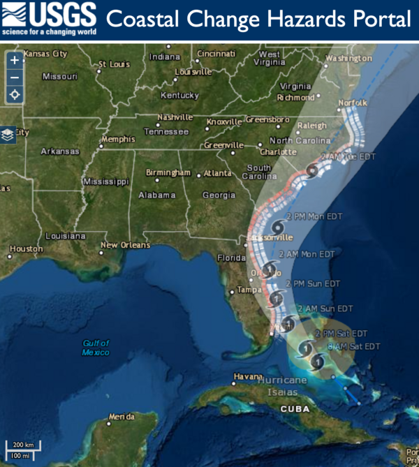
Hurricane Isaias Unlikely to Cause Widespread Atlantic Beach Erosion
USGS coastal change experts predict that storm waves kicked up by the Category 1 hurricane are likely to cause some erosion at the base of the dunes along about 11 percent of coastal beaches between Florida and Virginia.
USGS coastal change experts predict that storm waves kicked up by the Category 1 hurricane are likely to cause some erosion at the base of the dunes along about 11 percent of coastal beaches between Florida and Virginia.

Timelapse showing typical activity at Kīlauea's summit water lake
This timelapse video at Kīlauea's summit covers approximately 30 minutes and shows the dynamic nature of the water lake in Halema‘uma‘u crater. Steam from the hot water surface is constantly shifting in the winds, while the migrating color boundaries on the water surface appear to show circulation in the lake. USGS video by M. Patrick.
This timelapse video at Kīlauea's summit covers approximately 30 minutes and shows the dynamic nature of the water lake in Halema‘uma‘u crater. Steam from the hot water surface is constantly shifting in the winds, while the migrating color boundaries on the water surface appear to show circulation in the lake. USGS video by M. Patrick.

Kīlauea Volcano's summit water lake is one-year old
Plot showing rise of Kīlauea's summit crater lake over the past year, during which laser rangefinder measurements of lake level were made 2–3 times per week. Photos compare the lake on August 27, 2019, when it was ~22 ft (7 m) deep, to July 7, 2020, when it was ~130 ft (40 m) deep. USGS photos.
Plot showing rise of Kīlauea's summit crater lake over the past year, during which laser rangefinder measurements of lake level were made 2–3 times per week. Photos compare the lake on August 27, 2019, when it was ~22 ft (7 m) deep, to July 7, 2020, when it was ~130 ft (40 m) deep. USGS photos.

Continued slow rise of water in Halema‘uma‘u
Kīlauea's summit water lake, in Halema‘uma‘u, continues to slowly rise. Today, the lake colors were vibrant, with a zone of aquamarine water in the west end (lower right in photo). These greenish zones tend to be slightly hotter, and appear to be zones of water influx. USGS photo by M. Patrick.
Kīlauea's summit water lake, in Halema‘uma‘u, continues to slowly rise. Today, the lake colors were vibrant, with a zone of aquamarine water in the west end (lower right in photo). These greenish zones tend to be slightly hotter, and appear to be zones of water influx. USGS photo by M. Patrick.

Jezero crater, Mars
Description: This is a high-resolution oblique view of the northeastern edge of the delta deposit in Jezero crater, the landing site for the Perseverance Mars rover. In the foreground, buttes of delta material stand above the crater floor. On the left and in the middle of this image, the layered rocks of the delta deposit are visible.
Description: This is a high-resolution oblique view of the northeastern edge of the delta deposit in Jezero crater, the landing site for the Perseverance Mars rover. In the foreground, buttes of delta material stand above the crater floor. On the left and in the middle of this image, the layered rocks of the delta deposit are visible.

August 2019 to July 2020 summit lake comparison
Image comparison of Kīlauea summit lake on August 2, 2019 and July July 21, 2020
Image comparison of Kīlauea summit lake on August 2, 2019 and July July 21, 2020

No significant changes at Kīlauea's summit water lake
An HVO geologist collects GPS data on the western rim of Kīlauea's summit caldera. The geologist is standing upon a thick sequence of tephra deposits formed during explosive eruptions at Kīlauea's summit between about 1500 CE and the early 19th century.
An HVO geologist collects GPS data on the western rim of Kīlauea's summit caldera. The geologist is standing upon a thick sequence of tephra deposits formed during explosive eruptions at Kīlauea's summit between about 1500 CE and the early 19th century.

Comet NEOWISE and the Roosevelt Arch at Yellowstone National Park
Comet NEOWISE is seen with the Roosevelt Arch in the foreground at the north Entrance of Yellowstone National Park. The town of Gardiner, Montana, is in the background.
Comet NEOWISE is seen with the Roosevelt Arch in the foreground at the north Entrance of Yellowstone National Park. The town of Gardiner, Montana, is in the background.

Another view of the Fissure 8 channel, looking upstream. On the right, a lower
Another view of the Fissure 8 channel, looking upstream. On the right, a lower ledge along the channel wall represents the level of lava in the channel during the later stages of the flow. USGS photo by M. Patrick.
Another view of the Fissure 8 channel, looking upstream. On the right, a lower ledge along the channel wall represents the level of lava in the channel during the later stages of the flow. USGS photo by M. Patrick.

Views of the 2018 lower East Rift Zone lava flow field along Highway 132
HVO geologists visited the lower East Rift Zone lava flow field this past week to make measurements and observations, to better understand and reconstruct the dynamics of the Fissure 8 lava flow. This photo shows the channel wall in the braided channel region of the flow.
HVO geologists visited the lower East Rift Zone lava flow field this past week to make measurements and observations, to better understand and reconstruct the dynamics of the Fissure 8 lava flow. This photo shows the channel wall in the braided channel region of the flow.

A Legendary part of the Wailuku River is again revealed
View of the recently cleared Boiling Pots on the Wailuku River in Hilo. The pots, each about 15 m (50 ft) in diameter, are eroded into a 10,000 year old Mauna Loa lava flow. When the water is low, the river does not flow over some of the pot rims but it continues to flow through them. USGS photo.
View of the recently cleared Boiling Pots on the Wailuku River in Hilo. The pots, each about 15 m (50 ft) in diameter, are eroded into a 10,000 year old Mauna Loa lava flow. When the water is low, the river does not flow over some of the pot rims but it continues to flow through them. USGS photo.

Flyrock trajectory from the 24 June 2020 Whitney Portal Campground rockfall
Images showing the flyrock trajectory from the 24 June 2020 rockfall (see previous figure). Rock impacts at the base of the talus slope split and moved boulders, launching a 0.5 cubic meter boulder 92 m into the lower parking lot at Whitney Portal.
Images showing the flyrock trajectory from the 24 June 2020 rockfall (see previous figure). Rock impacts at the base of the talus slope split and moved boulders, launching a 0.5 cubic meter boulder 92 m into the lower parking lot at Whitney Portal.

In the eastern portion of the lake, the dark brown zone had a slightly mottled a
In the eastern portion of the lake, the dark brown zone had a slightly mottled appearance, but this pattern was transient and gone within about ten minutes.
In the eastern portion of the lake, the dark brown zone had a slightly mottled appearance, but this pattern was transient and gone within about ten minutes.

Continued slow rise of water in Halema‘uma‘u
The water lake within Halema‘uma‘u crater, at the summit of Kīlauea, continues to slowly rise, with no significant changes in recent weeks. USGS photo by M. Patrick.
The water lake within Halema‘uma‘u crater, at the summit of Kīlauea, continues to slowly rise, with no significant changes in recent weeks. USGS photo by M. Patrick.

The eastern end of the lake, shown here, is slightly warmer than the lake center
The eastern end of the lake, shown here, is slightly warmer than the lake center, and commonly has steam rising from the water surface. USGS photo by M. Patrick.
The eastern end of the lake, shown here, is slightly warmer than the lake center, and commonly has steam rising from the water surface. USGS photo by M. Patrick.

Vegetated dunes on Cocoa Beach, Florida
A view looking north on Cocoa beach towards Kennedy Space Station. Coastal infrastructure and natural resources such as sediment and beach vegetation can all be affected by coastal change processes.
A view looking north on Cocoa beach towards Kennedy Space Station. Coastal infrastructure and natural resources such as sediment and beach vegetation can all be affected by coastal change processes.

A large washover fan on Fire Island, New York in 2012 after Hurricane
Strong storms such as hurricanes can cause drastic changes to coastal environments. For example, this large washover fan was created on Fire Island, New York in 2012 after Hurricane Sandy by waves moving sediment from the dunes and beach towards the back-barrier environment.
Strong storms such as hurricanes can cause drastic changes to coastal environments. For example, this large washover fan was created on Fire Island, New York in 2012 after Hurricane Sandy by waves moving sediment from the dunes and beach towards the back-barrier environment.

Social distancing in the field
Safety is a top priority. USGS staff recently improved access to field sites at the Herring River estuary within the Cape Cod National Seashore to provide safer paths through a phragmites wetland.
Safety is a top priority. USGS staff recently improved access to field sites at the Herring River estuary within the Cape Cod National Seashore to provide safer paths through a phragmites wetland.

Extraordinary tenure ends for leader of USGS Hawaiian Volcano Observatory
Tina Neal, HVO Scientist-in-Charge from 2015–2020 ends her tenure on June 19, 2020. USGS photo.
Tina Neal, HVO Scientist-in-Charge from 2015–2020 ends her tenure on June 19, 2020. USGS photo.

During today's overflight of Kīlauea summit, both thermal and visual camera
During today's overflight of Kīlauea summit, both thermal and visual cameras were used to characterize activity. Comparing thermal (left) to visual (right) images of nearly the same view, you can see that the growing crater lake at Kīlauea's summit remains hot.
During today's overflight of Kīlauea summit, both thermal and visual cameras were used to characterize activity. Comparing thermal (left) to visual (right) images of nearly the same view, you can see that the growing crater lake at Kīlauea's summit remains hot.