
Temporary dike located South of Main Avenue Bridge in Fargo, North Dakota.
Images
Images intro.
Filter Total Items: 7146

Temporary Dike in Fargo
Temporary dike located South of Main Avenue Bridge in Fargo, North Dakota.

Red River of the North Flooding
Red River of the North flooding the 1st Avenue North Bridge in Fargo, ND.
Red River of the North flooding the 1st Avenue North Bridge in Fargo, ND.

Wild Rice River Flooding Bridge
The Wild Rice River near Abercrombie, North Dakota flooding.
The Wild Rice River near Abercrombie, North Dakota flooding.

Glacier Peak, northern WA
Glacier Peak is the tallest peak amongst a sea of many mountains in northern Washington.
Glacier Peak is the tallest peak amongst a sea of many mountains in northern Washington.

Upper west face of Glacier Peak, WA.
Upper west face of Glacier Peak, Washington.
Upper west face of Glacier Peak, Washington.

Studying Surf-Zone Hydrodynamics
USGS scientists Andrew Schwartz and Dan Hanes maneuver a current profiler for a study of surf-zone hydrodynamics at Ocean Beach, on the west side of San Francisco, California. Beach erosion has been a continuing problem in this area.
USGS scientists Andrew Schwartz and Dan Hanes maneuver a current profiler for a study of surf-zone hydrodynamics at Ocean Beach, on the west side of San Francisco, California. Beach erosion has been a continuing problem in this area.

A gas plume arising from Augustine Volcano during it's eruptive phase 2005-06.
A gas plume arising from Augustine Volcano during it's eruptive phase 2005-06. This photo was taken during a FLIR/maintenance flight on January 24, 2006.
A gas plume arising from Augustine Volcano during it's eruptive phase 2005-06. This photo was taken during a FLIR/maintenance flight on January 24, 2006.

Augustine Volcano
Augustine volcano viewed from the west.
Augustine volcano viewed from the west.

Kīlauea East Rift Zone lava flows and fissures, July 11, 1:00 p.m. HST
Map as of 1:00 p.m. HST, July 11, 2018. Given the dynamic nature of Kīlauea's lower East Rift Zone eruption, with changing vent locations, fissures starting and stopping, and varying rates of lava effusion, map details shown here are accurate as of the date/time noted. Shaded purple areas indicate lava flows erupted in 1840, 1955, 1960, and 2014-2015.
Map as of 1:00 p.m. HST, July 11, 2018. Given the dynamic nature of Kīlauea's lower East Rift Zone eruption, with changing vent locations, fissures starting and stopping, and varying rates of lava effusion, map details shown here are accurate as of the date/time noted. Shaded purple areas indicate lava flows erupted in 1840, 1955, 1960, and 2014-2015.

Kīlauea lower East Rift Zone lava
Helicopter overflight photo taken this morning - view toward the west directly above Kapoho Crater. The fissure 8 lava channel now bends sharply to the south on the western edge of the crater after being blocked and diverted yesterday.
Helicopter overflight photo taken this morning - view toward the west directly above Kapoho Crater. The fissure 8 lava channel now bends sharply to the south on the western edge of the crater after being blocked and diverted yesterday.

Crater Lake is the remnant of Mount Mazama, which erupted catastrop...
Crater Lake is the remnant of Mount Mazama, which erupted catastrophically 7,700 years ago to form the caldera.Wizard Island in lake and Mount Scott is peak on right shore. View from south. Oregon
Crater Lake is the remnant of Mount Mazama, which erupted catastrophically 7,700 years ago to form the caldera.Wizard Island in lake and Mount Scott is peak on right shore. View from south. Oregon

Tsunami wave field in Bay of Bengal
Tsunami wave field in the Bay of Bengal one hour after the M=9.1 Sumatra-Andaman earthquake on December 26, 2004. View looks to the northwest.
Tsunami wave field in the Bay of Bengal one hour after the M=9.1 Sumatra-Andaman earthquake on December 26, 2004. View looks to the northwest.

Shaded relief image of Nahant to Gloucester, MA
Shaded relief image of Nahant to Gloucester, MA
Shaded relief image of Nahant to Gloucester, MA

Topographic map, Mount St. Helens, C.E. 1919 annotated with locatio...
Due to the cataclysmic eruption of May 18, 1980, many of the locations annotated on this map are now either covered or no longer visible.
Due to the cataclysmic eruption of May 18, 1980, many of the locations annotated on this map are now either covered or no longer visible.
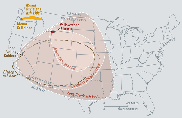
Map of the known ash-fall boundaries for several U.S. eruptions
Eruptions of the Yellowstone volcanic system have included the two largest volcanic eruptions in North America in the past few million years; the third largest was at Long Valley in California and produced the Bishop ash bed. The biggest of the Yellowstone eruptions occurred 2.1 million years ago, depositing the Huckleberry Ridge ash bed.
Eruptions of the Yellowstone volcanic system have included the two largest volcanic eruptions in North America in the past few million years; the third largest was at Long Valley in California and produced the Bishop ash bed. The biggest of the Yellowstone eruptions occurred 2.1 million years ago, depositing the Huckleberry Ridge ash bed.

Shaded relief image of the Outer Cape Cod, MA
Shaded relief image of the Outer Cape Cod, MA
Shaded relief image of the Outer Cape Cod, MA

Vents and lava flows from the Kīlauea eruption of 1955
This 88 day eruption spawned lava flows which crossed all major roads to lower Puna. Coastal villages from Kalapana to Kapoho were isolated. Major roads closed by lava included Pahoa-Pohoiki; Pahoa-Kapoho; Pahoa-Opihikao; and Pahoa-Kalapana as well as the lower Puna coastal highway.
This 88 day eruption spawned lava flows which crossed all major roads to lower Puna. Coastal villages from Kalapana to Kapoho were isolated. Major roads closed by lava included Pahoa-Pohoiki; Pahoa-Kapoho; Pahoa-Opihikao; and Pahoa-Kalapana as well as the lower Puna coastal highway.

USGS Debris-flow flume near Blue River, OR is used to conduct debris flow and landslide experiments.
linkUSGS Debris-flow flume near Blue River, Oregon is used to conduct debris flows and landslide experiments. Flume is a reinforced concrete channel 95 m (310 ft long, 2 m (6.6 ft) wide, and 1.2 m (4 ft).

Crater Lake from the air viewed from SW. Wizard Island is the coni...
Crater Lake from the air viewed from the southwest. Wizard Island is the conical mound in the lake and Mount Scott is the peak beyond the lake. Oregon
Crater Lake from the air viewed from the southwest. Wizard Island is the conical mound in the lake and Mount Scott is the peak beyond the lake. Oregon

Mount Jefferson, OR, aerial view as seen from the west.
Mount Jefferson, Oregon, aerial view as seen from the west.
Mount Jefferson, Oregon, aerial view as seen from the west.

Mount Adams, WA as seen from Mount St. Helens (west). Trees are co...
Mount Adams, Washington as seen from Mount St. Helens (west). Trees are covered in frost in the foreground.
Mount Adams, Washington as seen from Mount St. Helens (west). Trees are covered in frost in the foreground.