
USGS Science is Supporting Efforts to Reduce Vulnerability to Sea-Level Rise in Virginia
As the climate changes and sea levels rise, there is concern that sinking coastlines could exacerbate risks to infrastructure, as well as human and environmental health in coastal communities. The Virginia Coastal Plain is one of the fastest-sinking regions on the East Coast.
While some of the sinking, also known as subsidence, is due to deep Earth processes, much is caused by water being drawn from the confined Potomac aquifer faster than it can be replaced or recharged.
The Potomac aquifer is the source of most groundwater withdrawn in the Virginia Coastal Plain, making it key to understanding how to manage subsidence in the region. To assist partner agencies in managing sinking coastlines, sea level rise, and water resource needs, the USGS created tools to monitor the causes and extent of land subsidence more precisely in the Virginia Coastal Plain.

The Hampton Roads Sanitation District (HRSD) partners with the USGS to measure the effectiveness of its Sustainable Water Initiative for Tomorrow (SWIFT) program. The SWIFT program cleans wastewater so that it meets drinking water standards and can be used to recharge the Potomac aquifer in an effort to replenish it with clean water and combat land subsidence.
The recharge process involves multiple layers of advanced water treatment to produce SWIFT Water®, a clean water that meets drinking water standards and is used to recharge the Potomac aquifer through a series of recharge wells, providing a sustainable source of groundwater and potentially mitigating the land subsidence associated with overuse of the aquifer. HRSD wants to know if these efforts are having the desired effect and relies on USGS science to study this.
Jamie Mitchell and Dan Holloway of HRSD report that the SWIFT project would not be possible without the USGS Coastal Plain models of the Potomac aquifer, which are essential for understanding how the aquifer responds to withdrawals and how it can respond to recharge.

“There’s been a hand-in-glove relationship between USGS science and our efforts,” said Holloway.
Holloway has been working as a hydrogeologist for more than 25 years, and he and his colleagues rely heavily on the science performed by the USGS on the aquifer system. The USGS reports have been the definitive reference on the groundwater system for decades.
Greg Connock, a USGS Geologist, is committed to studying the precise sources of land subsidence on the Virginia Coastal Plain.
One of the most important tools Connock and his team use to measure subsidence is an extensometer, which USGS Hydrologist Jason Pope describes as “a ruler in a pipe that measures how much land around the extensometer is moving.”
Extensometers are rooted in the bedrock and move with crustal movement but are isolated from seasonal land motion, which allows scientists to measure aquifer system compaction and expansion more directly.
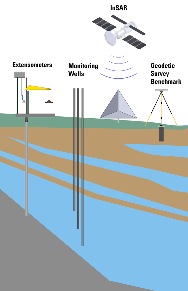
A study published in 2004 indicated that significant compaction has occurred in the sediment layers above the Potomac aquifer, despite the fact that most of the water is withdrawn directly from the aquifer. To improve understanding of the source of compaction in the Potomac aquifer system, USGS scientists use many different methods, including extensometers, InSar, geodetic surveys, and monitoring wells (pictured above).
HRSD has plans to recharge as much as 50 million gallons per day in the first phase of their SWIFT program. Though this doesn't completely offset actual use, this volume could impact the land subsidence that can be traced back to the overuse of the aquifer. Understanding whether and where aquifer compaction or expansion may be occurring in response to the SWIFT program depends on the precise measurements that the USGS data can provide.
The USGS co-located an extensometer at the site of HRSD's SWIFT Research Center in Suffolk, VA. This research center has the capacity to treat and recharge up to 1 million gallons per day and has been operational since 2018. Readings from the nearby USGS extensometer show that it can detect when HRSD withdraws water from the Potomac aquifer (typically done for operational maintenance of the recharge well) and when they recharge the aquifer, so there is reason to believe SWIFT is having an impact on aquifer compaction and expansion.
Additional USGS data are needed to determine exactly the magnitude and location of the impact, particularly as HRSD's full-scale SWIFT facilities begin recharging at higher, more beneficial rates beginning in 2026.

The USGS not only monitors subsidence on the Virginia Coastal Plain, but also partners with several agencies, such as the Virginia Department of Environmental Quality, that monitor falling groundwater levels and the loss of ground elevation If SWIFT recharge proves effective at mitigating land subsidence in Hampton Roads, then SWIFT could be highlighted as another important tool in combating the observed effects of sea level rise in the region.
The USGS work along the Virginia Coastal Plain provides agencies, such as the HRSD and the Virginia Department of Environmental Quality, with scientific data they need to inform management decisions that mitigate risks to infrastructure and human and environmental health. This novel work would not be possible without the support and collaboration from HRSD and the Virginia Department of Environmental Quality and may inform scientific and management ideas at similar sites across the US.
This story is part of the “Unleashing the Science” series, showcasing how bureaus within the Department of the Interior produce and apply science to ensure responsible management decisions for our planet now and for the future.

Related Content

Land Subsidence on the Virginia Coastal Plain
Related Content
Land Subsidence on the Virginia Coastal Plain
Get Our News
These items are in the RSS feed format (Really Simple Syndication) based on categories such as topics, locations, and more. You can install and RSS reader browser extension, software, or use a third-party service to receive immediate news updates depending on the feed that you have added. If you click the feed links below, they may look strange because they are simply XML code. An RSS reader can easily read this code and push out a notification to you when something new is posted to our site.