
Photo compilation of episodes 1–20 of the ongoing eruption at the summit of Kīlauea, including webcam imagery and photos taken by USGS Hawaiian Volcano Observatory scientists on the ground and during helicopter overflights. In all photos except for episode 7, the south vent is on the left and the north vent is on the right.
Multimedia
Webcams—Near-real-time images from webcams.
Videos—Collection of videos recorded during field excursions or caught on our webcams.
Image Galleries—Galleries of images and events with expanded descriptions.
The Kīlauea Photo and Video Chronology and Mauna Loa Photo and Video Chronology webpages also feature photos.
Images

Photo compilation of episodes 1–20 of the ongoing eruption at the summit of Kīlauea,
Photo compilation of episodes 1–20 of the ongoing eruption at the summit of Kīlauea, including webcam imagery and photos taken by USGS Hawaiian Volcano Observatory scientists on the ground and during helicopter overflights. In all photos except for episode 7, the south vent is on the left and the north vent is on the right.

May 7, 2025 — View of north vent at Kīlauea volcano
A view of north vent of the ongoing eruption within Halema‘uma‘u at Kīlauea volcano, about 12 hours after the end of episode 20. The solidified lava with a smooth silvery appearance in the center of the photo was produced as lava overflowed from north vent.
A view of north vent of the ongoing eruption within Halema‘uma‘u at Kīlauea volcano, about 12 hours after the end of episode 20. The solidified lava with a smooth silvery appearance in the center of the photo was produced as lava overflowed from north vent.

May 7, 2025 — Lava ooze-out at Kīlauea volcano 13 hours after episode 20
On May 7, 2025, about 13 hours after the end of episode 20 of the ongoing eruption at Kīlauea volcano, USGS Hawaiian Volcano Observatory scientists observed a lava ooze-out (center left in image) north of north vent (right side of image).
On May 7, 2025, about 13 hours after the end of episode 20 of the ongoing eruption at Kīlauea volcano, USGS Hawaiian Volcano Observatory scientists observed a lava ooze-out (center left in image) north of north vent (right side of image).

May 7, 2025 — Close-up view into north vent at Kīlauea volcano
Telephoto view looking into north vent (center) of the ongoing eruption within Halema‘uma‘u at Kīlauea volcano, about 13 hours after the end of episode 20. A conduit approximately 20 meters (66 feet) across is visible inside north vent (center bottom of image), which is approximately 60 meters (197 feet) across.
Telephoto view looking into north vent (center) of the ongoing eruption within Halema‘uma‘u at Kīlauea volcano, about 13 hours after the end of episode 20. A conduit approximately 20 meters (66 feet) across is visible inside north vent (center bottom of image), which is approximately 60 meters (197 feet) across.

May 7, 2025 — View into north vent at Kīlauea volcano
A view looking down on north vent (center) of the ongoing eruption within Halema‘uma‘u at Kīlauea volcano, about 13 hours after the end of episode 20. The south vent is degassing (white vapor rising) on the right side of the photo.
A view looking down on north vent (center) of the ongoing eruption within Halema‘uma‘u at Kīlauea volcano, about 13 hours after the end of episode 20. The south vent is degassing (white vapor rising) on the right side of the photo.

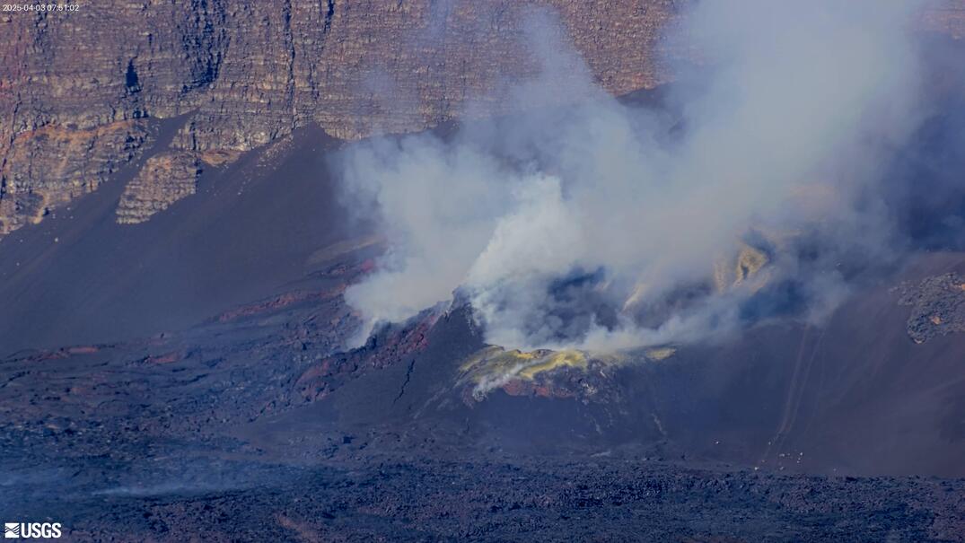
May 6, 2025 — Episode 20 at Kīlauea volcano
Lava fountains and flows erupted from both the north and south vents during episode 20 of the ongoing eruption at the summit of Kīlauea. However, the north vent was much more active than the south vent, with lava fountains reaching estimated heights of more than 500 feet (150 meters). Fountains from the south vent reached heights of up to about 65 feet (20 meters).
Lava fountains and flows erupted from both the north and south vents during episode 20 of the ongoing eruption at the summit of Kīlauea. However, the north vent was much more active than the south vent, with lava fountains reaching estimated heights of more than 500 feet (150 meters). Fountains from the south vent reached heights of up to about 65 feet (20 meters).
Videos

April 22, 2025 — Kīlauea Episode 18 Lava Fountaining Video
This video shows a clip from a USGS Hawaiian Volcano Observatory monitoring helicopter overflight on Tuesday, April 22, when high fountaining was occurring from the south vent at the summit of Kīlauea during episode 18 of the ongoing eruption. Other clips show activity captured during a field visit to the south rim of the caldera.
This video shows a clip from a USGS Hawaiian Volcano Observatory monitoring helicopter overflight on Tuesday, April 22, when high fountaining was occurring from the south vent at the summit of Kīlauea during episode 18 of the ongoing eruption. Other clips show activity captured during a field visit to the south rim of the caldera.

April 20, 2025 — Timelapse video of intermittent eruptive activity at Kīlauea
This timelapse video shows approximately 1 hour of activity compressed into 38 seconds, and covers a period of intermittent activity in the south vent the morning of April 20.
This timelapse video shows approximately 1 hour of activity compressed into 38 seconds, and covers a period of intermittent activity in the south vent the morning of April 20.

April 9, 2025 — VIews of episode 17 at Kīlauea summit, VIDEO
This video shows clips from a helicopter overflight and a field visit by USGS Hawaiian Volcano Observatory geologists to the crater rim to observe the lava fountaining in episode 17 of the ongoing summit eruption of Kīlauea.
This video shows clips from a helicopter overflight and a field visit by USGS Hawaiian Volcano Observatory geologists to the crater rim to observe the lava fountaining in episode 17 of the ongoing summit eruption of Kīlauea.

Timelapse video of episode 16 lava fountaining
This timelapse video shows lava fountaining during episode 16 of the ongoing summit eruption at Kīlauea. The fountain height rose rapidly during the onset and reached heights of about 300 meters (1000 feet). The fountain was relatively stable, but sometimes shows variations in inclination, presumably due to changes in vent geometry or wind direction.
This timelapse video shows lava fountaining during episode 16 of the ongoing summit eruption at Kīlauea. The fountain height rose rapidly during the onset and reached heights of about 300 meters (1000 feet). The fountain was relatively stable, but sometimes shows variations in inclination, presumably due to changes in vent geometry or wind direction.

April 1, 2025 — Kīlauea episode 16 lava fountain and flow VIDEO
Aerial video of Kīlauea summit eruption episode 16 lava fountain and its lava flow on April 1, 2025, taken during a USGS Hawaiian Volcano Observatory monitoring overflight at approximately noon. The lava fountain was reaching heights of more than 650 ft (200 m) at times and feeding a lava flow that as of noon on April 1 reached about 2,300 ft (700 m) from its vent.
Aerial video of Kīlauea summit eruption episode 16 lava fountain and its lava flow on April 1, 2025, taken during a USGS Hawaiian Volcano Observatory monitoring overflight at approximately noon. The lava fountain was reaching heights of more than 650 ft (200 m) at times and feeding a lava flow that as of noon on April 1 reached about 2,300 ft (700 m) from its vent.

March 29, 2025 — Timelapse video of episode 15 lava fountaining, Kīlauea
This timelapse video shows lava fountaining during episode 15 of the summit eruption at Kīlauea volcano. The sequence starts with small filling-draining cycles in the vent that abruptly shift into major fountaining. The inclination of the fountain changes repeatedly, depositing lava in varying directions around the vent.
This timelapse video shows lava fountaining during episode 15 of the summit eruption at Kīlauea volcano. The sequence starts with small filling-draining cycles in the vent that abruptly shift into major fountaining. The inclination of the fountain changes repeatedly, depositing lava in varying directions around the vent.
Audio

Lava lake activity from inside Halema`uma`u Crater
Sounds of lava lake activity within Kilauea Volcano's summit vent inside Halema`uma`u Crater on the afternoon of February 14, 2011. The continuous "crashing wave" noise is the sound of churning lava as gases are released from the lake surface, which is in nearly constant motion.
Sounds of lava lake activity within Kilauea Volcano's summit vent inside Halema`uma`u Crater on the afternoon of February 14, 2011. The continuous "crashing wave" noise is the sound of churning lava as gases are released from the lake surface, which is in nearly constant motion.

Dramatic Developments at Kilauea Volcano
Kilauea Volcano in Hawaii has experienced its first explosive eruption in more than 80 years and is now spewing noxious gas at 10 times the normal rate. John Eichelberger, head of the USGS Volcano Hazards Program, fills us in on the situation.
Kilauea Volcano in Hawaii has experienced its first explosive eruption in more than 80 years and is now spewing noxious gas at 10 times the normal rate. John Eichelberger, head of the USGS Volcano Hazards Program, fills us in on the situation.
Webcams
[V2cam] Kīlauea volcano, Hawaii (east Halemaʻumaʻu crater)
Live view of Kaluapele (Kīlauea caldera) and Halemaʻumaʻu crater, from the northeast rim of the caldera [V2cam]. This camera is a pan-tilt-zoom model and the view may change depending on activity.
Disclaimer
Live view of Kaluapele (Kīlauea caldera) and Halemaʻumaʻu crater, from the northeast rim of the caldera [V2cam]. This camera is a pan-tilt-zoom model and the view may change depending on activity.
Disclaimer
[S2cam] - View of Halemaʻumaʻu crater at the summit of Kīlauea, view is to the west
Live view of Halemaʻumaʻu crater at the summit of Kīlauea; camera is positioned on the south rim and the view is to the west [S2cam].
Disclaimer
Live view of Halemaʻumaʻu crater at the summit of Kīlauea; camera is positioned on the south rim and the view is to the west [S2cam].
Disclaimer

[KOcam] Live Image of upper East Rift Zone from Maunaulu
This image is from a temporary research camera positioned near Maunaulu, looking northwest toward the upper East Rift Zone of Kīlauea.
Disclaimer
This image is from a temporary research camera positioned near Maunaulu, looking northwest toward the upper East Rift Zone of Kīlauea.
Disclaimer

[MDLcam] The Upper and Middle Parts of Mauna Loa's Southwest Rift Zone
Live image of Mauna Loa's upper and middle Southwest Rift Zone from Dandelion Cone along the middle part of the rift zone [MDLcam]. This camera is a pan-tilt-zoom model and the view may change depending on activity.
Disclaimer
Live image of Mauna Loa's upper and middle Southwest Rift Zone from Dandelion Cone along the middle part of the rift zone [MDLcam]. This camera is a pan-tilt-zoom model and the view may change depending on activity.
Disclaimer

[MSPcam] Mauna Loa's Southwest Rift Zone from the South Point area
Live image of Mauna Loa's Southwest Rift Zone from the South Point area [MSPcam]. This camera is a pan-tilt-zoom model and the view may change depending on activity.
Disclaimer
Live image of Mauna Loa's Southwest Rift Zone from the South Point area [MSPcam]. This camera is a pan-tilt-zoom model and the view may change depending on activity.
Disclaimer
[MITDcam] Kīlauea upper Southwest Rift Zone
[MITDcam] Live view of Kīlauea's upper Southwest Rift Zone, looking northwest from a seismic station in the Kaʻū Desert.
[MITDcam] Live view of Kīlauea's upper Southwest Rift Zone, looking northwest from a seismic station in the Kaʻū Desert.