
Photo compilation of episodes 1–20 of the ongoing eruption at the summit of Kīlauea, including webcam imagery and photos taken by USGS Hawaiian Volcano Observatory scientists on the ground and during helicopter overflights. In all photos except for episode 7, the south vent is on the left and the north vent is on the right.
Images
Hawaiian Volcano Observatory images of eruptive activity, field work, and more.
Filter Total Items: 3396

Photo compilation of episodes 1–20 of the ongoing eruption at the summit of Kīlauea,
Photo compilation of episodes 1–20 of the ongoing eruption at the summit of Kīlauea, including webcam imagery and photos taken by USGS Hawaiian Volcano Observatory scientists on the ground and during helicopter overflights. In all photos except for episode 7, the south vent is on the left and the north vent is on the right.

May 7, 2025 — View of north vent at Kīlauea volcano
A view of north vent of the ongoing eruption within Halema‘uma‘u at Kīlauea volcano, about 12 hours after the end of episode 20. The solidified lava with a smooth silvery appearance in the center of the photo was produced as lava overflowed from north vent.
A view of north vent of the ongoing eruption within Halema‘uma‘u at Kīlauea volcano, about 12 hours after the end of episode 20. The solidified lava with a smooth silvery appearance in the center of the photo was produced as lava overflowed from north vent.

May 7, 2025 — Lava ooze-out at Kīlauea volcano 13 hours after episode 20
On May 7, 2025, about 13 hours after the end of episode 20 of the ongoing eruption at Kīlauea volcano, USGS Hawaiian Volcano Observatory scientists observed a lava ooze-out (center left in image) north of north vent (right side of image).
On May 7, 2025, about 13 hours after the end of episode 20 of the ongoing eruption at Kīlauea volcano, USGS Hawaiian Volcano Observatory scientists observed a lava ooze-out (center left in image) north of north vent (right side of image).

May 7, 2025 — Close-up view into north vent at Kīlauea volcano
Telephoto view looking into north vent (center) of the ongoing eruption within Halema‘uma‘u at Kīlauea volcano, about 13 hours after the end of episode 20. A conduit approximately 20 meters (66 feet) across is visible inside north vent (center bottom of image), which is approximately 60 meters (197 feet) across.
Telephoto view looking into north vent (center) of the ongoing eruption within Halema‘uma‘u at Kīlauea volcano, about 13 hours after the end of episode 20. A conduit approximately 20 meters (66 feet) across is visible inside north vent (center bottom of image), which is approximately 60 meters (197 feet) across.

May 7, 2025 — View into north vent at Kīlauea volcano
A view looking down on north vent (center) of the ongoing eruption within Halema‘uma‘u at Kīlauea volcano, about 13 hours after the end of episode 20. The south vent is degassing (white vapor rising) on the right side of the photo.
A view looking down on north vent (center) of the ongoing eruption within Halema‘uma‘u at Kīlauea volcano, about 13 hours after the end of episode 20. The south vent is degassing (white vapor rising) on the right side of the photo.

May 6, 2025 — Episode 20 at Kīlauea volcano
Lava fountains and flows erupted from both the north and south vents during episode 20 of the ongoing eruption at the summit of Kīlauea. However, the north vent was much more active than the south vent, with lava fountains reaching estimated heights of more than 500 feet (150 meters). Fountains from the south vent reached heights of up to about 65 feet (20 meters).
Lava fountains and flows erupted from both the north and south vents during episode 20 of the ongoing eruption at the summit of Kīlauea. However, the north vent was much more active than the south vent, with lava fountains reaching estimated heights of more than 500 feet (150 meters). Fountains from the south vent reached heights of up to about 65 feet (20 meters).
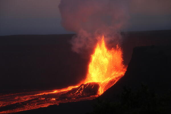
May 6, 2025 — North vent lava fountaining at Kīlauea volcano
During episode 20 of the ongoing eruption in Halemaʻumaʻu at the summit of Kīlauea, lava fountains reached about 500 feet (152 meters). The crater wall behind the vents is 492 feet (150 meters) high, and this photo shows that the top of the fountain from the north vent is reaching slightly higher than the crater wall.
During episode 20 of the ongoing eruption in Halemaʻumaʻu at the summit of Kīlauea, lava fountains reached about 500 feet (152 meters). The crater wall behind the vents is 492 feet (150 meters) high, and this photo shows that the top of the fountain from the north vent is reaching slightly higher than the crater wall.

May 6, 2025 — Telephoto view of the north vent erupting at Kīlauea volcano
Dusk view of episode 20 fountaining activity at the north vent within Halemaʻumaʻu at the summit of Kīlauea. This photograph was taken from just east of the Kīlauea Overlook within Hawaiʻi Volcanoes National Park. The pali (cliff) of Kaluapele (Kīlauea summit caldera) is visible in the foreground, while a plume of volcanic gas is illuminated in the dusk light.
Dusk view of episode 20 fountaining activity at the north vent within Halemaʻumaʻu at the summit of Kīlauea. This photograph was taken from just east of the Kīlauea Overlook within Hawaiʻi Volcanoes National Park. The pali (cliff) of Kaluapele (Kīlauea summit caldera) is visible in the foreground, while a plume of volcanic gas is illuminated in the dusk light.

May 6, 2025 — Telephoto view of north vent lava fountain at Kīlauea volcano
The continuous fountaining phase of episode 20 in the ongoing Kīlauea summit eruption was brief, lasting just 4.5 hours. The fountaining phase began at 5:28 p.m. HST and ended at 9:58 p.m. HST the evening of May 6, 2025. USGS photo by K. Mulliken.
The continuous fountaining phase of episode 20 in the ongoing Kīlauea summit eruption was brief, lasting just 4.5 hours. The fountaining phase began at 5:28 p.m. HST and ended at 9:58 p.m. HST the evening of May 6, 2025. USGS photo by K. Mulliken.

May 5, 2025 — Telephoto view of south vent at Kīlauea volcano
This view of the south vent within Halemaʻumaʻu crater at the summit of Kīlauea was captured through the lens of a laser rangefinder device that Hawaiian Volcano Observatory scientists were using to measure eruptive features.
This view of the south vent within Halemaʻumaʻu crater at the summit of Kīlauea was captured through the lens of a laser rangefinder device that Hawaiian Volcano Observatory scientists were using to measure eruptive features.

May 5, 2025 — Eruptive activity within north and south vents at Kīlauea volcano
On May 5, 2025, the north and south vents of Kīlauea's ongoing summit eruption were alternating in vigor over the course of 10-minute cycles.
On May 5, 2025, the north and south vents of Kīlauea's ongoing summit eruption were alternating in vigor over the course of 10-minute cycles.
May 5, 2025 — Lava dome fountain within north vent at Kīlauea volcano
On May 5, 2025, USGS Hawaiian Volcano Observatory scientists visiting the western rim of Halemaʻumaʻu crater watched several cycles of lava filling and draining within the north vent of Kīlauea's ongoing summit eruption. Dome fountains in the vent's lava pond reached approximately 6 meters (20 feet) in height.
On May 5, 2025, USGS Hawaiian Volcano Observatory scientists visiting the western rim of Halemaʻumaʻu crater watched several cycles of lava filling and draining within the north vent of Kīlauea's ongoing summit eruption. Dome fountains in the vent's lava pond reached approximately 6 meters (20 feet) in height.

May 1, 2025 — Scientist checks camera on rim of Kīlauea volcano
May 1 is lei day in Hawaii, and today scientists from the USGS Hawaiian Volcano Observatory checked on the S2cam on the rim of Kīlauea volcano. The camera had been sending images intermittently over the past 24 hours and needed new batteries.
May 1 is lei day in Hawaii, and today scientists from the USGS Hawaiian Volcano Observatory checked on the S2cam on the rim of Kīlauea volcano. The camera had been sending images intermittently over the past 24 hours and needed new batteries.

May 1, 2025 — View of lava within north vent between eruptive episodes at Kīlauea volcano
On May 1, 2025, USGS Hawaiian Volcano Observatory scientists observed a small spatter cone that has built up within the north vent in Halemaʻumaʻu. Over the past day, spattering has been visible in the V1cam livestream within the north vent and this photo provides a closer view of the spattering source. USGS photo by K. Mulliken.
On May 1, 2025, USGS Hawaiian Volcano Observatory scientists observed a small spatter cone that has built up within the north vent in Halemaʻumaʻu. Over the past day, spattering has been visible in the V1cam livestream within the north vent and this photo provides a closer view of the spattering source. USGS photo by K. Mulliken.

May 1, 2025—Kīlauea summit eruption monitoring
A USGS Hawaiian Volcano Observatory scientist uses a handheld laser rangefinder to determine the height of the small spatter cone within the north vent on May 1, 2025. USGS photo by K. Mulliken.
A USGS Hawaiian Volcano Observatory scientist uses a handheld laser rangefinder to determine the height of the small spatter cone within the north vent on May 1, 2025. USGS photo by K. Mulliken.

May 1, 2025 — Scientist sets up camera on rim of Kīlauea volcano
A USGS Hawaiian Volcano Observatory geologist sets up a video camera to capture the intermittent minor spattering within the north vent in Halemaʻumaʻu on May 1, 2025. The north and south vents are just out of the camera frame, below the scientist in the lower left part of the photo.
A USGS Hawaiian Volcano Observatory geologist sets up a video camera to capture the intermittent minor spattering within the north vent in Halemaʻumaʻu on May 1, 2025. The north and south vents are just out of the camera frame, below the scientist in the lower left part of the photo.

May 1, 2025 — View of the north vent at Kīlauea volcano
On May 1, 2025, USGS Hawaiian Volcano Observatory scientists observed a small spatter cone that had built up by intermittent spattering within the north vent over the past several days in Halemaʻumaʻu.
On May 1, 2025, USGS Hawaiian Volcano Observatory scientists observed a small spatter cone that had built up by intermittent spattering within the north vent over the past several days in Halemaʻumaʻu.

April 30, 2025—Kīlauea summit eruption reference map
This reference map depicts the Kīlauea summit eruption within Halema‘uma‘u crater that began on December 23, 2024. As of this posting on April 30, 2025, the eruption has had eighteen episodes, with the most recent occurring on April 22.
This reference map depicts the Kīlauea summit eruption within Halema‘uma‘u crater that began on December 23, 2024. As of this posting on April 30, 2025, the eruption has had eighteen episodes, with the most recent occurring on April 22.

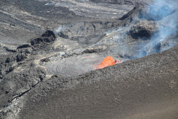
April 29, 2025 — View of lava within north vent between eruptive episodes at Kīlauea volcano
On April 29, the USGS Hawaiian Volcano Observatory undertook a helicopter surveillance flight over Halema‘uma‘u at the summit of Kīlauea volcano. At the time, the ongoing eruption was between eruptive episodes (episode 18 ended on April 22). In this photo looking down towards the east, lava is seen within north vent.
On April 29, the USGS Hawaiian Volcano Observatory undertook a helicopter surveillance flight over Halema‘uma‘u at the summit of Kīlauea volcano. At the time, the ongoing eruption was between eruptive episodes (episode 18 ended on April 22). In this photo looking down towards the east, lava is seen within north vent.

April 29, 2025 — Lava visible within both north and south vents between eruptive episodes at Kīlauea volcano
linkOn April 29, the USGS Hawaiian Volcano Observatory undertook a helicopter surveillance flight over Halema‘uma‘u at the summit of Kīlauea volcano. At the time, the ongoing eruption was between eruptive episodes (episode 18 ended on April 22).

April 29, 2025 — View of lava within north vent at Kīlauea volcano
On April 29, the USGS Hawaiian Volcano Observatory undertook a helicopter surveillance flight over Halema‘uma‘u at the summit of Kīlauea volcano. At the time, the ongoing eruption was between eruptive episodes (episode 18 ended on April 22). In this photo looking down towards the east, lava is seen within north vent.
On April 29, the USGS Hawaiian Volcano Observatory undertook a helicopter surveillance flight over Halema‘uma‘u at the summit of Kīlauea volcano. At the time, the ongoing eruption was between eruptive episodes (episode 18 ended on April 22). In this photo looking down towards the east, lava is seen within north vent.