
A USGS Hawaiian Volcano Observatory geologist collected of molten sample of lava in the eastern portion of Halema‘uma‘u crater the morning of March 4, 2025. In this portion of the crater, far from the eruptive vents, lava has slowly oozed out in recent days as residue from earlier episodes.
Images
Hawaiian Volcano Observatory images of eruptive activity, field work, and more.
Filter Total Items: 3330

March 4, 2025 — Kīlauea summit eruption sample
A USGS Hawaiian Volcano Observatory geologist collected of molten sample of lava in the eastern portion of Halema‘uma‘u crater the morning of March 4, 2025. In this portion of the crater, far from the eruptive vents, lava has slowly oozed out in recent days as residue from earlier episodes.

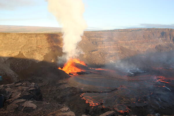
March 4, 2025 — Episode 12 at the summit of Kīlauea
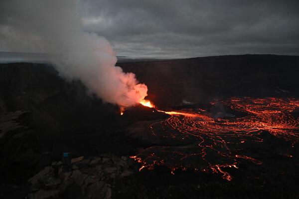
Episode 12 of the ongoing Halemaʻumaʻu eruption began a fountaining phase at 2 p.m. HST on March 4. Several small lava flows came from the south vent during the morning and early afternoon of March 4. At 2:00 p.m. HST, fountaining began at the north vent.
Episode 12 of the ongoing Halemaʻumaʻu eruption began a fountaining phase at 2 p.m. HST on March 4. Several small lava flows came from the south vent during the morning and early afternoon of March 4. At 2:00 p.m. HST, fountaining began at the north vent.

March 4, 2025 — Kaluapele panorama
A panoramic view of Kaluapele, the caldera at the summit of Kīlauea volcano, taken from the Volcano House Hotel overlook in Hawaiʻi Volcanoes National Park. The intermittently active vents on the west wall of the caldera are visibly degassing in the shadowed background of the image, while Mauna Loa is illuminated in the sunlight.
A panoramic view of Kaluapele, the caldera at the summit of Kīlauea volcano, taken from the Volcano House Hotel overlook in Hawaiʻi Volcanoes National Park. The intermittently active vents on the west wall of the caldera are visibly degassing in the shadowed background of the image, while Mauna Loa is illuminated in the sunlight.

February 26, 2025 — Series of photos of the final 40 minutes of episode 11 of Kīlauea summit eruption
linkEpisode 11 of the ongoing summit eruption at Kīlauea started yesterday, February 25 at 6:22 p.m. HST and ended this morning, February 26 at 7:06 a.m. Field crews witnessed the last 40 minutes of episode 11, documented in this series of photos taken from the western rim of the volcano's summit caldera, looking southeast.

February 26, 2025 — Gas measurements following episode 11 at Kīlauea summit
A Hawaiian Volcano Observatory geologist measures the chemistry of volcanic gases emitted by Kīlauea summit eruption episode 11—within Halemaʻumaʻu crater—on February 26, 2025. USGS photo by M. Patrick.
A Hawaiian Volcano Observatory geologist measures the chemistry of volcanic gases emitted by Kīlauea summit eruption episode 11—within Halemaʻumaʻu crater—on February 26, 2025. USGS photo by M. Patrick.

February 26, 2025 — The aftermath of episode 11 at Kīlauea summit
A Hawaiian Volcano Observatory geologist uses a laser rangefinder to measure the evolving height of cinder cones produced by recent lava fountaining at the summit of Kīlauea. Today, February 26, the highest part of the tallest cone rim was about 160 feet (48 meters) above the crater floor. USGS photo by M. Patrick.
A Hawaiian Volcano Observatory geologist uses a laser rangefinder to measure the evolving height of cinder cones produced by recent lava fountaining at the summit of Kīlauea. Today, February 26, the highest part of the tallest cone rim was about 160 feet (48 meters) above the crater floor. USGS photo by M. Patrick.

February 26, 2025 — Tephra from episode 11 fountaining at Kīlauea summit
Recent lava fountaining at the summit of Kīlauea has produced large frothy clasts that have landed on the western caldera rim, in addition to many smaller clasts that have produced a thick carpet of new tephra. USGS photo by M. Patrick.
Recent lava fountaining at the summit of Kīlauea has produced large frothy clasts that have landed on the western caldera rim, in addition to many smaller clasts that have produced a thick carpet of new tephra. USGS photo by M. Patrick.

February 26, 2025 — Lava clasts from episode 11 fountaining at Kīlauea summit
The density of clasts produced by recent fountaining at the summit of Kīlauea is similar to that of a kitchen sponge, due to abundant gas bubbles. These bubbles range in size from ones too small to see, up to larger ones about the size of golf balls. USGS photo by M. Patrick.
The density of clasts produced by recent fountaining at the summit of Kīlauea is similar to that of a kitchen sponge, due to abundant gas bubbles. These bubbles range in size from ones too small to see, up to larger ones about the size of golf balls. USGS photo by M. Patrick.

February 26, 2025 — Lava clast from episode 11 fountaining at Kīlauea summit
The shapes and textures of clasts produced by recent lava fountaining at the summit of Kīlauea also indicate their fluid nature as they traveled through the air. USGS photo by M. Patrick.
The shapes and textures of clasts produced by recent lava fountaining at the summit of Kīlauea also indicate their fluid nature as they traveled through the air. USGS photo by M. Patrick.

February 26, 2025 — The end of episode 11 fountaining at Kīlauea summit
Hawaiian Volcano Observatory geologists visited the caldera rim at Kīlauea this morning and observed the end of the summit eruption's eleventh episode, as fountains shut down at both eruptive vents between approximately 6:30 and 7:00 am.
Hawaiian Volcano Observatory geologists visited the caldera rim at Kīlauea this morning and observed the end of the summit eruption's eleventh episode, as fountains shut down at both eruptive vents between approximately 6:30 and 7:00 am.
February 20, 2025 — Overview of episode 10 of the summit eruption of Kīlauea
An overview of episode 10 of the ongoing Halemaʻumaʻu eruption the morning of February 20, 2025. Episode 10 ended later that morning at 9:18 a.m HST, after just under 13 hours of fountaining.
An overview of episode 10 of the ongoing Halemaʻumaʻu eruption the morning of February 20, 2025. Episode 10 ended later that morning at 9:18 a.m HST, after just under 13 hours of fountaining.

February 20, 2025 — Episode 10 of Halemaʻumaʻu eruption, Kīlauea
USGS Hawaiian Volcano Observatory (HVO) geologists captured this view of episode 10 of the Kīlauea summit eruption in Halema‘uma‘u during a sunrise field shift on February 20, 2025. HVO scientists measured fountain heights of about 45-50 m (148-164 feet) on average with frequent pulses reaching 60-65 meters (197-213 feet).
USGS Hawaiian Volcano Observatory (HVO) geologists captured this view of episode 10 of the Kīlauea summit eruption in Halema‘uma‘u during a sunrise field shift on February 20, 2025. HVO scientists measured fountain heights of about 45-50 m (148-164 feet) on average with frequent pulses reaching 60-65 meters (197-213 feet).

February 20, 2025 — Telephoto view of north vent erupting at Kīlauea
A telephoto view of the north vent erupting during episode 10 of the 2024-2025 Halemʻumaʻu eruption within Kaluapele, the summit caldera of Kīlauea. USGS photo by L. Gallant during the morning of February 20, 2025.
A telephoto view of the north vent erupting during episode 10 of the 2024-2025 Halemʻumaʻu eruption within Kaluapele, the summit caldera of Kīlauea. USGS photo by L. Gallant during the morning of February 20, 2025.
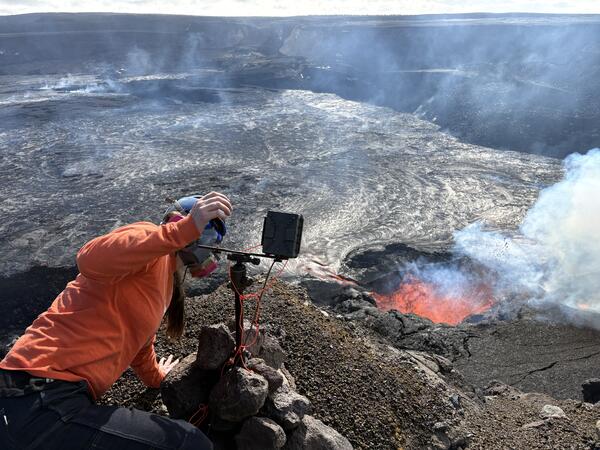
February 20, 2025 — HVO scientists monitor Kīlauea eruption
A Hawaiian Volcano Observatory (HVO) scientist checks the settings on a temporarily deployed camera. Infrastructure in this area is subject to the occasional volcanic bomb strike and may also experience intense heat.
A Hawaiian Volcano Observatory (HVO) scientist checks the settings on a temporarily deployed camera. Infrastructure in this area is subject to the occasional volcanic bomb strike and may also experience intense heat.
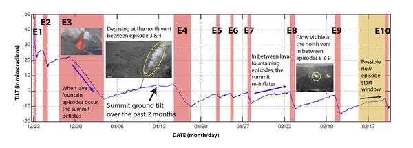
Ground tilt for Kīlauea summit eruption episodes December 2024-February 2025
Ground tilt and eruptive episodes associated with Kīlauea summit eruption December 23, 2024, until February 20, 2025. The ten eruptive episodes in Halemaʻumaʻu are highlighted in red.
Ground tilt and eruptive episodes associated with Kīlauea summit eruption December 23, 2024, until February 20, 2025. The ten eruptive episodes in Halemaʻumaʻu are highlighted in red.
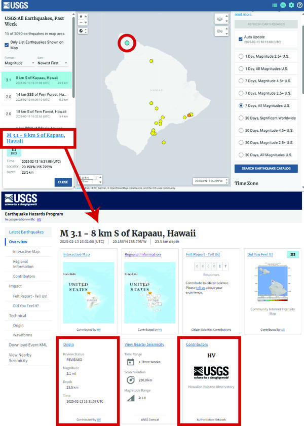
Screenshots of the USGS Latest Earthquakes page and a USGS event page
Screenshots of the USGS Latest Earthquakes page and the USGS event page for a M3.1 that occurred at 6:31 a.m. HST on February 13, 2025, north of Kapaʻau on the Island of Hawaiʻi. Selecting the event’s hyperlink on the USGS Latest Earthquakes webpage (red box top panel) will take the user to the event’s overview page (lower panel).
Screenshots of the USGS Latest Earthquakes page and the USGS event page for a M3.1 that occurred at 6:31 a.m. HST on February 13, 2025, north of Kapaʻau on the Island of Hawaiʻi. Selecting the event’s hyperlink on the USGS Latest Earthquakes webpage (red box top panel) will take the user to the event’s overview page (lower panel).

February 12, 2025 — Kīlauea summit overflight Halemaʻumaʻu overview
A patchwork of lava flows of different colors and different ages cover the floor of Halema‘uma‘u, at the summit of Kīlauea. Nine lava fountaining episodes in the southwest part of Kalupele since December 23, 2024, have fed lava flows that work their way east across the caldera floor. Although episode 9 of the eruption paused February 12, at 8:43 a.m.
A patchwork of lava flows of different colors and different ages cover the floor of Halema‘uma‘u, at the summit of Kīlauea. Nine lava fountaining episodes in the southwest part of Kalupele since December 23, 2024, have fed lava flows that work their way east across the caldera floor. Although episode 9 of the eruption paused February 12, at 8:43 a.m.
February 12, 2025 — Eruptive activity in Halema‘uma‘u, Kīlauea summit
At 7 a.m. HST on February 12, 2025, episode 9 of Kīlauea's 2024-2025 eruption continued at both the north and south vents with fountain heights of 45-50 m (148-164 feet). The south vent fountain was inclined (at an angle) to the east. Both vents fed active lava flows that stretched over one kilometer (0.62 miles) across the floor of Halema‘uma‘u. USGS photo by K.
At 7 a.m. HST on February 12, 2025, episode 9 of Kīlauea's 2024-2025 eruption continued at both the north and south vents with fountain heights of 45-50 m (148-164 feet). The south vent fountain was inclined (at an angle) to the east. Both vents fed active lava flows that stretched over one kilometer (0.62 miles) across the floor of Halema‘uma‘u. USGS photo by K.

February 12, 2025 — Eruptive activity at the vents in Halemaʻumaʻu, Kīlauea
Around 7 a.m. HST on February 12, 2025, USGS Hawaiian Volcano Observatory (HVO) field crews observed vigorous fountaining from both the north and south vents of the ongoing 2024-2025 eruption. The south and north cones were 31 m (102 feet) and 45 m (148 feet) tall, respectively. USGS photo by K. Lynn.
Around 7 a.m. HST on February 12, 2025, USGS Hawaiian Volcano Observatory (HVO) field crews observed vigorous fountaining from both the north and south vents of the ongoing 2024-2025 eruption. The south and north cones were 31 m (102 feet) and 45 m (148 feet) tall, respectively. USGS photo by K. Lynn.

February 12, 2025 — Abrupt end in episode 9 eruptive activity at Kīlauea summit
Abruptly at 8:30 a.m. HST on February 12, 2025, USGS Hawaiian Volcano Observatory field crews nearby heard the shutdown of fountaining at the north vent. Visual confirmation at 8:34 a.m. confirmed that the north vent was no longer active, and the south vent fountain was greatly reduced and no longer inclined to the east.
Abruptly at 8:30 a.m. HST on February 12, 2025, USGS Hawaiian Volcano Observatory field crews nearby heard the shutdown of fountaining at the north vent. Visual confirmation at 8:34 a.m. confirmed that the north vent was no longer active, and the south vent fountain was greatly reduced and no longer inclined to the east.

February 12, 2025 — Cessation of activity at the south vent, Kīlauea summit
Over the course of ten minutes, USGS Hawaiian Volcano Observatory field crews observed the south vent activity cease until lava could no longer be seen or heard from the south vent. At 8:43 a.m. HST on February 12, 2025, episode 9 of the 2024-2025 Halema‘uma‘u eruption was over. USGS photo by K. Lynn.
Over the course of ten minutes, USGS Hawaiian Volcano Observatory field crews observed the south vent activity cease until lava could no longer be seen or heard from the south vent. At 8:43 a.m. HST on February 12, 2025, episode 9 of the 2024-2025 Halema‘uma‘u eruption was over. USGS photo by K. Lynn.