
An area of forest continues to burn in a remote area on the south rim of Nāpau Crater following the recent eruption on Kīlauea’s middle East Rift Zone, within Hawai‘i Volcanoes National Park. Beginning around 4 p.m. HST on October 6, a smoke plume from the burning vegetation became visible in HVO webcam imagery, and intermittent incandescence was seen overnight.
Multimedia
Webcams—Near-real-time images from webcams.
Videos—Collection of videos recorded during field excursions or caught on our webcams.
Image Galleries—Galleries of images and events with expanded descriptions.
The Kīlauea Photo and Video Chronology and Mauna Loa Photo and Video Chronology webpages also feature photos.
Images

October 7, 2024 — Nāpau Crater forest fire continues to burn
An area of forest continues to burn in a remote area on the south rim of Nāpau Crater following the recent eruption on Kīlauea’s middle East Rift Zone, within Hawai‘i Volcanoes National Park. Beginning around 4 p.m. HST on October 6, a smoke plume from the burning vegetation became visible in HVO webcam imagery, and intermittent incandescence was seen overnight.
October 7, 2024 — Nāpau Crater forest fire continues to burn
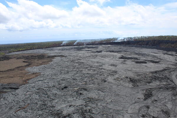
On the middle East Rift Zone of Kīlauea, a recent eruption covered a large portion of the Nāpau Crater floor with new lava—dark gray lava near center of image. This eruption started a forest fire that continues to burn vegetation along the southern rim of Nāpau Crater. Photo view looking northwest with Kānenuiohamo visible in the upper left.
On the middle East Rift Zone of Kīlauea, a recent eruption covered a large portion of the Nāpau Crater floor with new lava—dark gray lava near center of image. This eruption started a forest fire that continues to burn vegetation along the southern rim of Nāpau Crater. Photo view looking northwest with Kānenuiohamo visible in the upper left.
October 7, 2024 — Nāpau Crater forest fire continues to burn
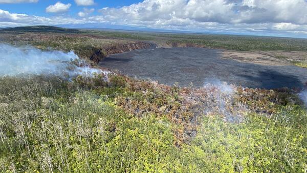
This aerial photo of Nāpau Crater, looking south, shows the lava flows (gray) from the recent Kīlauea middle East Rift Zone eruption. Along the south rim of the crater (background of image), smoke plumes are visible from a small wildfire that continues to burn in a remote area of Hawai‘i Volcanoes National Park. USGS photo taken by L.
This aerial photo of Nāpau Crater, looking south, shows the lava flows (gray) from the recent Kīlauea middle East Rift Zone eruption. Along the south rim of the crater (background of image), smoke plumes are visible from a small wildfire that continues to burn in a remote area of Hawai‘i Volcanoes National Park. USGS photo taken by L.

October 7, 2024 — Nāpau Crater forest fire continues to burn
Kīlauea volcano is not erupting. An ongoing wildfire in the vicinity of the recent eruption area near Nāpau Crater in Hawai‘i Volcanoes National Park has been intermittently visible in HVO webcam imagery.
Kīlauea volcano is not erupting. An ongoing wildfire in the vicinity of the recent eruption area near Nāpau Crater in Hawai‘i Volcanoes National Park has been intermittently visible in HVO webcam imagery.

October 4, 2024 — Reference map of September 2024 Kīlauea middle East Rift Zone eruption
This reference map depicts the final state of the Kīlauea middle East Rift Zone eruption that occurred between September 15 and 20, 2024. The eruptive fissures stretched along 1.8 kilometers (1.1 miles) of the East Rift Zone, with the longest lava flow extending 1.4 kilometers (0.9 miles) from the main eruptive vent, which was situated west of Nāpau Crater.
This reference map depicts the final state of the Kīlauea middle East Rift Zone eruption that occurred between September 15 and 20, 2024. The eruptive fissures stretched along 1.8 kilometers (1.1 miles) of the East Rift Zone, with the longest lava flow extending 1.4 kilometers (0.9 miles) from the main eruptive vent, which was situated west of Nāpau Crater.
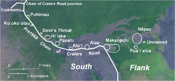
Chain of Craters within Hawaiʻi Volcanoes National Park before 1969
Chain of Craters within Hawaiʻi Volcanoes National Park before 1969, when several craters were partly or completely filled with lava. Now the Chain of Craters Road turns south, away from its pre-1969 route, between Pauahi and ʻAloʻi, a pit crater buried in 1969 by Maunaulu lava flows. The junction with the Hilina Pali Road is essentially at Devil’s Throat.
Chain of Craters within Hawaiʻi Volcanoes National Park before 1969, when several craters were partly or completely filled with lava. Now the Chain of Craters Road turns south, away from its pre-1969 route, between Pauahi and ʻAloʻi, a pit crater buried in 1969 by Maunaulu lava flows. The junction with the Hilina Pali Road is essentially at Devil’s Throat.
Videos

September 20, 2024—Kīlauea middle East Rift Zone eruption overflight and ground views
USGS Hawaiian Volcano Observatory field monitoring crews captured these videos during their visit to Kīlauea middle East Rift Zone eruption site the morning of September 20, 2024. They reported minor spattering and small fountains at one end of the vent at 8:30 a.m. HST. By 10 a.m.
USGS Hawaiian Volcano Observatory field monitoring crews captured these videos during their visit to Kīlauea middle East Rift Zone eruption site the morning of September 20, 2024. They reported minor spattering and small fountains at one end of the vent at 8:30 a.m. HST. By 10 a.m.

September 19, 2024—New lava flows on the middle East Rift Zone of Kīlauea
On September 19, 2024, USGS-Hawaiian Volcano Observatory geologists landed near the Kīlauea middle East Rift Zone eruption site, where they viewed lava flowing through a channel more than 50 meters (about 164 feet) wide.
On September 19, 2024, USGS-Hawaiian Volcano Observatory geologists landed near the Kīlauea middle East Rift Zone eruption site, where they viewed lava flowing through a channel more than 50 meters (about 164 feet) wide.

September 20, 2024 —Kīlauea middle East Rift Zone eruption summary
On the night of September 15, USGS Hawaiian Volcano Observatory geophysical data indicated that an eruption could be occurring a remote area of Kīlauea’s middle East Rift Zone, within Hawaiʻi Volcanoes National Park.
On the night of September 15, USGS Hawaiian Volcano Observatory geophysical data indicated that an eruption could be occurring a remote area of Kīlauea’s middle East Rift Zone, within Hawaiʻi Volcanoes National Park.

September 19, 2024 —Kīlauea lava fountains erupting
On September 19, USGS Hawaiian Volcano Observatory geologists were able to capture this video of the fissure vent eruption west of Nāpau Crater on the middle East Rift Zone of Kīlauea. They observed a 150-m-long (nearly 500 feet) fissure west of the crater erupting lava in a curtain of lava 10-20 meters (33-66 feet) high.
On September 19, USGS Hawaiian Volcano Observatory geologists were able to capture this video of the fissure vent eruption west of Nāpau Crater on the middle East Rift Zone of Kīlauea. They observed a 150-m-long (nearly 500 feet) fissure west of the crater erupting lava in a curtain of lava 10-20 meters (33-66 feet) high.

September 19, 2024 — Kīlauea middle East Rift Zone eruption overflight
USGS Hawaiian Volcano Observatory geologists conducted a reconnaissance overflight of the eruption near Nāpau Crater on the middle East Rift Zone of Kīlauea. They observed lava cascading over the rim of the crater from a channel more than 50 meters (about 164 feet) wide.
USGS Hawaiian Volcano Observatory geologists conducted a reconnaissance overflight of the eruption near Nāpau Crater on the middle East Rift Zone of Kīlauea. They observed lava cascading over the rim of the crater from a channel more than 50 meters (about 164 feet) wide.

September 17, 2024 —Kīlauea middle East Rift Zone eruption sampling
USGS Hawaiian Volcano Observatory geologists collected a sample of the middle East Rift Zone Kīlauea eruption in Nāpau Crater, within a closed area Hawaiʻi Volcanoes National Park. Geologists put molten lava into a metal bucket and rapidly quench it with water.
USGS Hawaiian Volcano Observatory geologists collected a sample of the middle East Rift Zone Kīlauea eruption in Nāpau Crater, within a closed area Hawaiʻi Volcanoes National Park. Geologists put molten lava into a metal bucket and rapidly quench it with water.
Audio

Lava lake activity from inside Halema`uma`u Crater
Sounds of lava lake activity within Kilauea Volcano's summit vent inside Halema`uma`u Crater on the afternoon of February 14, 2011. The continuous "crashing wave" noise is the sound of churning lava as gases are released from the lake surface, which is in nearly constant motion.
Sounds of lava lake activity within Kilauea Volcano's summit vent inside Halema`uma`u Crater on the afternoon of February 14, 2011. The continuous "crashing wave" noise is the sound of churning lava as gases are released from the lake surface, which is in nearly constant motion.

Dramatic Developments at Kilauea Volcano
Kilauea Volcano in Hawaii has experienced its first explosive eruption in more than 80 years and is now spewing noxious gas at 10 times the normal rate. John Eichelberger, head of the USGS Volcano Hazards Program, fills us in on the situation.
Kilauea Volcano in Hawaii has experienced its first explosive eruption in more than 80 years and is now spewing noxious gas at 10 times the normal rate. John Eichelberger, head of the USGS Volcano Hazards Program, fills us in on the situation.
Webcams
[S2cam] - View of Nāpau Crater on the East Rift Zone of Kīlauea, view is to the southwest
Live view of Nāpau Crater on the East Rift Zone of Kīlauea, view is to the southwest [S2cam].
Disclaimer
Live view of Nāpau Crater on the East Rift Zone of Kīlauea, view is to the southwest [S2cam].
Disclaimer

[KOcam] Live Image of upper East Rift Zone from Maunaulu
This image is from a temporary research camera positioned near Maunaulu, looking northwest toward the upper East Rift Zone of Kīlauea.
Disclaimer
This image is from a temporary research camera positioned near Maunaulu, looking northwest toward the upper East Rift Zone of Kīlauea.
Disclaimer

[MDLcam] The Upper and Middle Parts of Mauna Loa's Southwest Rift Zone
Live image of Mauna Loa's upper and middle Southwest Rift Zone from Dandelion Cone along the middle part of the rift zone [MDLcam]. This camera is a pan-tilt-zoom model and the view may change depending on activity.
Disclaimer
Live image of Mauna Loa's upper and middle Southwest Rift Zone from Dandelion Cone along the middle part of the rift zone [MDLcam]. This camera is a pan-tilt-zoom model and the view may change depending on activity.
Disclaimer

[MSPcam] Mauna Loa's Southwest Rift Zone from the South Point area
Live image of Mauna Loa's Southwest Rift Zone from the South Point area [MSPcam]. This camera is a pan-tilt-zoom model and the view may change depending on activity.
Disclaimer
Live image of Mauna Loa's Southwest Rift Zone from the South Point area [MSPcam]. This camera is a pan-tilt-zoom model and the view may change depending on activity.
Disclaimer
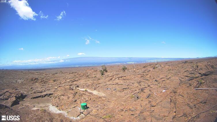
[MITDcam] Kīlauea upper Southwest Rift Zone
[MITDcam] Live view of Kīlauea's upper Southwest Rift Zone, looking northwest from a seismic station in the Kaʻū Desert.
[MITDcam] Live view of Kīlauea's upper Southwest Rift Zone, looking northwest from a seismic station in the Kaʻū Desert.

[B2cam] Halemaʻumaʻu crater from the east rim and down-dropped block
[B2cam] This image is from a research camera located on the down-dropped block in Kīlauea caldera and east rim of Halemaʻumaʻu crater within Hawaiʻi Volcanoes National Park. The camera is looking west towards Halemaʻumaʻu crater.
Disclaimer
[B2cam] This image is from a research camera located on the down-dropped block in Kīlauea caldera and east rim of Halemaʻumaʻu crater within Hawaiʻi Volcanoes National Park. The camera is looking west towards Halemaʻumaʻu crater.
Disclaimer