
Glacial end moraine deposits on south flank of Mauna Kea, Hawai‘i
Images
Explore our planet through photography and imagery, including climate change and water all the way back to the 1800s when the USGS was surveying the country by horse and buggy.
Filter Total Items: 21462
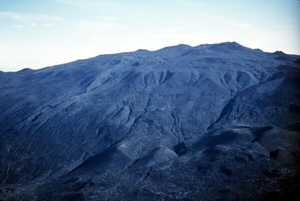
Glacial end moraine deposits on south flank of Mauna Kea, Hawai‘i
Glacial end moraine deposits on south flank of Mauna Kea, Hawai‘i

Northeast flank Mauna Kea, Hawai‘i from about 5,200 ft to summit. P...
The light colored lava flows in foreground are part of the older Laupahoehoe Volcanics, erupted between 70,000 to 13,000 years ago. one of the youngest cinder cones erupted by the volcano,
The light colored lava flows in foreground are part of the older Laupahoehoe Volcanics, erupted between 70,000 to 13,000 years ago. one of the youngest cinder cones erupted by the volcano,

Pu‘umaKAHAKOkanaka, NE flank of Mauna Kea, Hawai‘i
12,398 ft elev according to USGS Geographic Names Information System
12,398 ft elev according to USGS Geographic Names Information System

Upper south flank of Mauna Kea, Hawai‘i. Prominent cinder cone (low...
Pu‘u Keonehehe‘e and the two small cones immediately to the northwest (left) are among the youngest cones erupted on the volcano, as recent as about 4,000 years ago. The other cones in this view are part of the Laupahoehoe Volcanics, but much older, dating to 70,000 years ago.
Pu‘u Keonehehe‘e and the two small cones immediately to the northwest (left) are among the youngest cones erupted on the volcano, as recent as about 4,000 years ago. The other cones in this view are part of the Laupahoehoe Volcanics, but much older, dating to 70,000 years ago.

Deformation measurements on the Mount St. Helens' dome; three geolo...
Deformation measurements on the Mount St. Helens' dome; three geologists in middle bottom of this aerial photograph.
Deformation measurements on the Mount St. Helens' dome; three geologists in middle bottom of this aerial photograph.

China's Qaidam Basin Landscape Similar with Mars
Geologist, sedimentation expert and Mars Science Laboratory team member David Rubin of the USGS Pacific Coastal and Marine Science Center investigates longitudinal dunes in China's Qaidam Basin. He comments: "The landscape has some similarity with Mars: almost total lack of vegetation and wind-formed landscape."
Geologist, sedimentation expert and Mars Science Laboratory team member David Rubin of the USGS Pacific Coastal and Marine Science Center investigates longitudinal dunes in China's Qaidam Basin. He comments: "The landscape has some similarity with Mars: almost total lack of vegetation and wind-formed landscape."

Tephra jet explosion, Kīlauea, Hawai‘i
Explosive interaction between lava and seawater blasts a tephra jet consisting of steam, hot water, black tephra, and molten fragments into the air. This explosion is directed primarily toward the sea, but many explosions also send a shower of lava more than 10 to 20 m inland.
Explosive interaction between lava and seawater blasts a tephra jet consisting of steam, hot water, black tephra, and molten fragments into the air. This explosion is directed primarily toward the sea, but many explosions also send a shower of lava more than 10 to 20 m inland.

Mount Adams southern view as seen from Trout Lake, WA. Trout Lake s...
Mount Adams southern view as seen from Trout Lake, Washington. Trout Lake sits on thick lahar deposits that originated as a debris avalanche 6,000 years ago.
Mount Adams southern view as seen from Trout Lake, Washington. Trout Lake sits on thick lahar deposits that originated as a debris avalanche 6,000 years ago.

False-colored-composite satellite image, Great Salt Lake, Sept 1987
This is a false-colored-composite satellite image of the Great Salt Lake, taken in Sept, 1987. Vegetation appears red.
This is a false-colored-composite satellite image of the Great Salt Lake, taken in Sept, 1987. Vegetation appears red.

Mount Thielsen (2,799 m or 9,182 ft) is an extinct volcano north of...
Mount Thielsen (2,799 m or 9,182 ft) is an extinct volcano north of Crater Lake, Oregon that last erupted 250,000 years ago. Aerial view.
Mount Thielsen (2,799 m or 9,182 ft) is an extinct volcano north of Crater Lake, Oregon that last erupted 250,000 years ago. Aerial view.

Dome building eruption at Mount St. Helens—30-minute, moon-lit expo...
The last dome-building eruption of Mount St. Helens during the 1980s occurred in October 1986. A new lobe was extruded, increasing the dome's height to 925 feet (282 meters), making it taller than a 77-story building. In volume, the dome was nearly 40 times the size of Seattle's Kingdome stadium.
The last dome-building eruption of Mount St. Helens during the 1980s occurred in October 1986. A new lobe was extruded, increasing the dome's height to 925 feet (282 meters), making it taller than a 77-story building. In volume, the dome was nearly 40 times the size of Seattle's Kingdome stadium.

View of the Spirit Lake outlet tunnel, built in 1985, that allows w...
View of the Spirit Lake outlet tunnel, built in 1985, that allows water to drain out of Spirit Lake safely and maintain the lake's water level 100 ft (30 m) below the estimated overtopping level.
View of the Spirit Lake outlet tunnel, built in 1985, that allows water to drain out of Spirit Lake safely and maintain the lake's water level 100 ft (30 m) below the estimated overtopping level.

Volga River Delta at the Caspian Sea
The Volga River is the longest river in Europe and empties into the northwestern part of the Caspian Sea. The green in this image is algal bloom mixed with mud, the result of the chemical pollutants deposited in the Delta.
The Volga River is the longest river in Europe and empties into the northwestern part of the Caspian Sea. The green in this image is algal bloom mixed with mud, the result of the chemical pollutants deposited in the Delta.

San Andreas Fault in SE Coachella Valley
Oblique aerial view of San Andreas Fault (between white arrows) in southeastern Coachella Valley, near Red Canyon; view to the west.
Oblique aerial view of San Andreas Fault (between white arrows) in southeastern Coachella Valley, near Red Canyon; view to the west.

Catastrophic Landslide
The Mameyes, Puerto Rico, landslide, 1985. This landslide destroyed 120 houses and killed at least 129 people. The catastrophic slide was triggered by a tropical storm that produced extremely heavy rainfall.
The Mameyes, Puerto Rico, landslide, 1985. This landslide destroyed 120 houses and killed at least 129 people. The catastrophic slide was triggered by a tropical storm that produced extremely heavy rainfall.

Cape Flattery topographic map, 1985
Topographic map of the Cape Flattery region (U.S. Geological Survey Cape Flattery Quadrangle, 15-min series).
Topographic map of the Cape Flattery region (U.S. Geological Survey Cape Flattery Quadrangle, 15-min series).

Three Sisters volcanoes (left to right - South, Middle, and North)
Three Sisters volcanoes (left to right - South, Middle, and North) viewed from the south, Oregon. Foreground rhyolite Newberry flow is one of most recent eruptive units (2.2 ka).
Three Sisters volcanoes (left to right - South, Middle, and North) viewed from the south, Oregon. Foreground rhyolite Newberry flow is one of most recent eruptive units (2.2 ka).

Lava dome in Mount St. Helens' crater as viewed from the "Deepthroa...
The lava dome was taller than a 66-story building and almost as wide as the length of nine football fields. The dome completely fills the camera's field of view. Compare with image taken August 22, 1981 from the same location with the same camera.
The lava dome was taller than a 66-story building and almost as wide as the length of nine football fields. The dome completely fills the camera's field of view. Compare with image taken August 22, 1981 from the same location with the same camera.

USGS station 08110500 Navasota Riv. near Easterly, Tex.
U.S. Geological Survey streamflow-gaging station 08110500 Navasota River near Easterly, Texas, looking upstream from left bank, July 22, 1985.
SIR 2009–5174
U.S. Geological Survey streamflow-gaging station 08110500 Navasota River near Easterly, Texas, looking upstream from left bank, July 22, 1985.
SIR 2009–5174

Underground cavities beneath Ledges Sink, Fl
Water flow in the underlying cavity associated with Ledges Sink.
Water flow in the underlying cavity associated with Ledges Sink.

Underground cavities beneath Ledges Sink, Fl
Logs that fall through the overlying bedrock litter the cavern floor.
Logs that fall through the overlying bedrock litter the cavern floor.