
Catch of forage fish from a trawl in Cook Inlet, Alaska. Trawling was part of an assessment of abundance, distribution and species composition of forage fish in marine waters in lower Cook Inlet.
Images
Total: 0
Settings
Total: 0
Explore our planet through photography and imagery, including climate change and water all the way back to the 1800s when the USGS was surveying the country by horse and buggy.
Filter Total Items: 21537
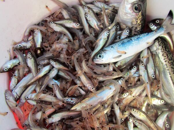
Catch of forage fish from a trawl in Cook Inlet, Alaska
Catch of forage fish from a trawl in Cook Inlet, Alaska. Trawling was part of an assessment of abundance, distribution and species composition of forage fish in marine waters in lower Cook Inlet.

Harmful algal blooms turn lake water emerald green
Harmful algal blooms turn water in Milford Lake emerald green
Harmful algal blooms turn water in Milford Lake emerald green

Harmful algal blooms turn water in Milford Lake emerald green
Harmful algal blooms turn water in Milford Lake emerald green
Harmful algal blooms turn water in Milford Lake emerald green

Milford Lake from Timelapse Cam
A view of Milford Lake from a timelapse camera installed near the water's edge. In the background the otherside of the lake and a bridge can be seen.
A view of Milford Lake from a timelapse camera installed near the water's edge. In the background the otherside of the lake and a bridge can be seen.

Dr. Chris Farmer measures the tarsus of a palila
Palila, a critically endangered Hawaiian bird found only the slopes of Mauna Kea volcano, Hawai‘i Island, Hawai‘i, have faced several threats including invasive cats, rats, and mongoose, and loss of habitat. Dr. Paul Banko has spent decades of his career studying palila populations and threats. In this photo, Dr.
Palila, a critically endangered Hawaiian bird found only the slopes of Mauna Kea volcano, Hawai‘i Island, Hawai‘i, have faced several threats including invasive cats, rats, and mongoose, and loss of habitat. Dr. Paul Banko has spent decades of his career studying palila populations and threats. In this photo, Dr.

Landsat Pine Beetle Pair
Landsat image taken in 1992 shows the Uinta Mountains east of Salt Lake City. The shades of dark green indicate healthy, undisturbed forest. Landsat image of the same area in 2010 captures the dramatic assault of mountain pine beetles. The dark red stains reveal widespread pine beetle destruction.
Landsat image taken in 1992 shows the Uinta Mountains east of Salt Lake City. The shades of dark green indicate healthy, undisturbed forest. Landsat image of the same area in 2010 captures the dramatic assault of mountain pine beetles. The dark red stains reveal widespread pine beetle destruction.

Spiny Sunstar
Digital still photograph from Massachusetts Bay near Scituate, MA showing Spiny Sunstar (Crossaster papposus), yellow encrusting Crumb of Bread Sponge (Halichondria panacea) on rock (top center), white tubular (right bottom corner) and boulders covered in pink bubblegum algae. Water depth at this location is approximately 27 meters.
Digital still photograph from Massachusetts Bay near Scituate, MA showing Spiny Sunstar (Crossaster papposus), yellow encrusting Crumb of Bread Sponge (Halichondria panacea) on rock (top center), white tubular (right bottom corner) and boulders covered in pink bubblegum algae. Water depth at this location is approximately 27 meters.

A Horned Puffin flying over the water
A Horned Puffin flying over the water
A Horned Puffin flying over the water

Gage at Milford Lake
A photo of USGS equipment and monitoring site on a bridge at Milford Lake.
A photo of USGS equipment and monitoring site on a bridge at Milford Lake.

Harmful algal blooms turn lake water emerald green
Harmful algal blooms turn lake water emerald green
Harmful algal blooms turn lake water emerald green

Harmful algal blooms turn water in Milford Lake emerald green
Harmful algal blooms turn water in Milford Lake emerald green
Harmful algal blooms turn water in Milford Lake emerald green

Horned Puffin, near Chisik Island in Lower Cook Inlet, Alaska
Horned Puffin, one of the species affected by a recent seabird die-off in the Pribilof Islands, AK. Near Chisik Island in Lower Cook Inlet, Alaska
Horned Puffin, one of the species affected by a recent seabird die-off in the Pribilof Islands, AK. Near Chisik Island in Lower Cook Inlet, Alaska

Molybdenite mineral coating on a fractured surface
Molybdenite mineral coating on a fractured surface in Tertiary granite north of Lake Clark
Molybdenite mineral coating on a fractured surface in Tertiary granite north of Lake Clark

New technology to monitor harmful algal blooms
New technology is helping the USGS monitor harmful algal blooms
New technology is helping the USGS monitor harmful algal blooms

Newly hatched pallid sturgeon free embryos.
Pallid sturgeon free embryos on the day of hatch, approximately 8-9 mm (about 0.33 of an inch) in length.
Pallid sturgeon free embryos on the day of hatch, approximately 8-9 mm (about 0.33 of an inch) in length.

Pallid sturgeon free embryo at approximately 10 days post-hatch
Pallid sturgeon free embryo at approximately 10 days post-hatch, approximately 19-20 mm (about 0.77 of an inch) in length.
Pallid sturgeon free embryo at approximately 10 days post-hatch, approximately 19-20 mm (about 0.77 of an inch) in length.

Pallid sturgeon free embryo at approximately 2 days post-hatch
Pallid sturgeon free embryo at approximately 2 days post-hatch, approximately 11-12 mm (about 0.45 of an inch) in length.
Pallid sturgeon free embryo at approximately 2 days post-hatch, approximately 11-12 mm (about 0.45 of an inch) in length.

Pallid sturgeon free embryo at approximately 5 days post-hatch
Figure 3. Pallid sturgeon free embryo at approximately 5 days post-hatch, approximately 14-15 mm (about 0.57 of an inch) in length.
Figure 3. Pallid sturgeon free embryo at approximately 5 days post-hatch, approximately 14-15 mm (about 0.57 of an inch) in length.

Columbia River Research Laboratory
Image of the Western Fisheries Research Center, Columbia River Research Laboratory, Cook, WA
Image of the Western Fisheries Research Center, Columbia River Research Laboratory, Cook, WA

Extensional structural features of the 2014 SR530 landslide near Oso
USGS hydrologist Mark Reid examines an extensional basin in the middle of the Oso landslide deposit. The headscarp (near-vertical cliff at the back of the landslide) is visible at the top of the image. The prominent tree is one of many that fell and became perched as the landslide spread out over the river valley.
USGS hydrologist Mark Reid examines an extensional basin in the middle of the Oso landslide deposit. The headscarp (near-vertical cliff at the back of the landslide) is visible at the top of the image. The prominent tree is one of many that fell and became perched as the landslide spread out over the river valley.

Lake Trout
Lake trout historically supported the most valuable freshwater commercial fisheries in North America, but their populations crashed in parts of the Great Lakes during the 1950s and 1960s due to overfishing and invasive species.
Lake trout historically supported the most valuable freshwater commercial fisheries in North America, but their populations crashed in parts of the Great Lakes during the 1950s and 1960s due to overfishing and invasive species.