
Zooming in even closer, an HVO scientist captured this image of the water on the floor of the crater during today's overflight. For more information, please read "Water or no water: that is (or was) the question"—HVO's Aug.
Images
Volcano Hazard Program images.
Filter Total Items: 6226

Zooming in even closer, an HVO scientist captured this image of the water on the
Zooming in even closer, an HVO scientist captured this image of the water on the floor of the crater during today's overflight. For more information, please read "Water or no water: that is (or was) the question"—HVO's Aug.

Cistern Spring, Yellowstone National Park, both full and drained
Photographs of Cistern Spring showing the draining behavior that occurs after major water eruptions of Steamboat Geyser. Left: about 2.5 hours after the onset of a major Steamboat eruption. Right: about 19.5 hours after that eruption.
Photographs of Cistern Spring showing the draining behavior that occurs after major water eruptions of Steamboat Geyser. Left: about 2.5 hours after the onset of a major Steamboat eruption. Right: about 19.5 hours after that eruption.

Glacial erratic near the Grand Canyon of the Yellowstone in Yellowstone National
This huge boulder was dropped by a retreating glacier on the north rim of the Grand Canyon of the Yellowstone in Yellowstone National Park, and it is a testament to Yellowstone's icy past.
This huge boulder was dropped by a retreating glacier on the north rim of the Grand Canyon of the Yellowstone in Yellowstone National Park, and it is a testament to Yellowstone's icy past.

Mauna Loa caldera
HVO staff visited the summit of Mauna Loa on foot to repair the webcam on April 24. The weather was perfectly clear and views of the caldera floor showed nothing unusual.
HVO staff visited the summit of Mauna Loa on foot to repair the webcam on April 24. The weather was perfectly clear and views of the caldera floor showed nothing unusual.

HVO geologist walks along the Mauna Loa summit trail
An HVO geologist walks along the Mauna Loa summit trail, with Mauna Kea visible in the distant background.
An HVO geologist walks along the Mauna Loa summit trail, with Mauna Kea visible in the distant background.

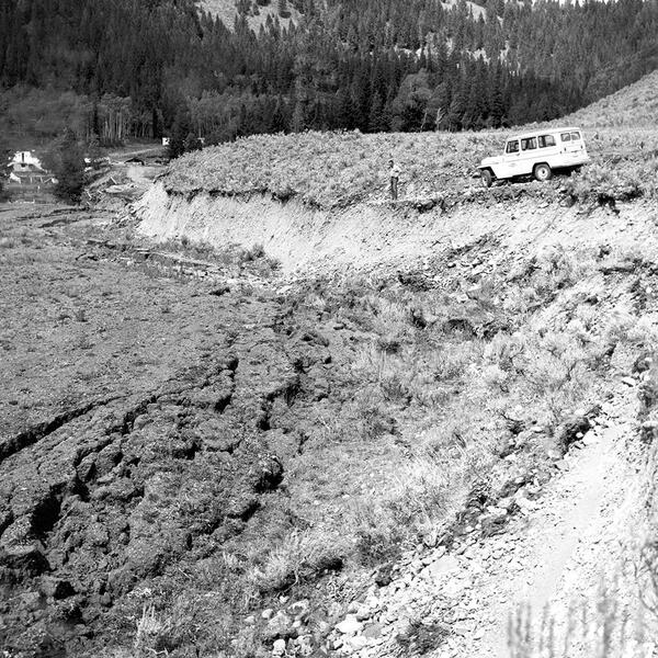
Rockslide damage to the Golden Gate area near Mammoth Hot Springs, Yellowstone N
Rockslide damage to the Golden Gate area near Mammoth Hot Springs, Yellowstone National Park, as a result of the 1959 Hebgen Lake earthquake.
Rockslide damage to the Golden Gate area near Mammoth Hot Springs, Yellowstone National Park, as a result of the 1959 Hebgen Lake earthquake.

Seismic geyser in eruption in 1970.
Seismic geyser in eruption in 1970. Photo by John Brandow.
Seismic geyser in eruption in 1970. Photo by John Brandow.
Hebgen Lake fault scarp in 1959
Hebgen Lake fault scarp in 1959. USGS photo by J. R. Stacy.
Hebgen Lake fault scarp in 1959. USGS photo by J. R. Stacy.

HVO scientists inspect a seismic station on Mauna Loa
HVO scientists inspect a seismic station on Mauna Loa to evaluate for a possible equipment upgrade in the near future.
HVO scientists inspect a seismic station on Mauna Loa to evaluate for a possible equipment upgrade in the near future.

HVO scientists measure a GPS instrument
HVO scientists measure a GPS instrument to ensure its stability during a multi-day deployment in the Kahuku Unit of Hawai‘i Volcanoes National Park.
HVO scientists measure a GPS instrument to ensure its stability during a multi-day deployment in the Kahuku Unit of Hawai‘i Volcanoes National Park.
Map of moderate, high and very high threat volcanoes monitored by the California
Map of moderate, high and very high threat volcanoes monitored by the California
Map of moderate, high and very high threat volcanoes monitored by the California

A close-up of the active fumarole field on the north wall of the pit.
A close-up of the active fumarole field on the north wall of the pit.
A close-up of the active fumarole field on the north wall of the pit.

Sunny weather at Kīlauea summit, no significant changes
The weather was warm and sunny during a routine visit to the Halema‘uma‘u webcam. No significant changes were observed, and no rockfalls were heard.
The weather was warm and sunny during a routine visit to the Halema‘uma‘u webcam. No significant changes were observed, and no rockfalls were heard.

Webicorder for PNSN TDH seismometer located on the southwestern flank of Mount H
Webicorder for PNSN TDH seismometer located on the southwestern flank of Mount H
Webicorder for PNSN TDH seismometer located on the southwestern flank of Mount H

Mauna Loa's 1975 eruption in terms of today's Volcano Alert Level
As the sun rose above Mauna Kea (background) on July 6, 1975, eruptive fissures along the Northeast Rift Zone of Mauna Loa fed voluminous ‘a‘ā lava flows that quickly moved down the north flank of the volcano. USGS photo by D. Peterson.
As the sun rose above Mauna Kea (background) on July 6, 1975, eruptive fissures along the Northeast Rift Zone of Mauna Loa fed voluminous ‘a‘ā lava flows that quickly moved down the north flank of the volcano. USGS photo by D. Peterson.

. Schematic model showing a cross section of Old Faithful
Schematic model showing a cross section of Old Faithful's plumbing system as determined from seismic studies. The red circles (t0-t3) show the location of the tremor source over time, and how the tremor source migrates upward prior to an Old Faithful eruption. Times between red circles are based on a 93-minute eruption interval.
Schematic model showing a cross section of Old Faithful's plumbing system as determined from seismic studies. The red circles (t0-t3) show the location of the tremor source over time, and how the tremor source migrates upward prior to an Old Faithful eruption. Times between red circles are based on a 93-minute eruption interval.

GPS survey is completed annually on Mauna Loa
A high-precision Global Positioning System (GPS) survey is completed annually on Mauna Loa. This station was occupied for a period of three days to supplement the continuously operating GPS stations on the volcano. A beautiful view of Mauna Kea (in distance) could seen from this site during the GPS survey.
A high-precision Global Positioning System (GPS) survey is completed annually on Mauna Loa. This station was occupied for a period of three days to supplement the continuously operating GPS stations on the volcano. A beautiful view of Mauna Kea (in distance) could seen from this site during the GPS survey.

Earthquake swarms at Mount St. Helens
Graphic shows the earthquake swarm from June-July, 2019, compared to previous swarms detected in March 2019, 2017, 2016, and in 2014. The activity is likely the result of small-scale underground movements of hydrothermal fluids or gas — a sign that Mount St. Helens remains an active volcano.
Graphic shows the earthquake swarm from June-July, 2019, compared to previous swarms detected in March 2019, 2017, 2016, and in 2014. The activity is likely the result of small-scale underground movements of hydrothermal fluids or gas — a sign that Mount St. Helens remains an active volcano.

HVO geologists make field observations in the lower East Rift Zone
What does a hardened lava flow look like? This photograph is of the frothy top of a lava flow near the fissure 8 vent, on Kīlauea Volcano's lower East Rift Zone. The different sizes and abundance of bubbles in the surface texture create different colors of the lava, including the light brown and darker black near the boot (for scale).
What does a hardened lava flow look like? This photograph is of the frothy top of a lava flow near the fissure 8 vent, on Kīlauea Volcano's lower East Rift Zone. The different sizes and abundance of bubbles in the surface texture create different colors of the lava, including the light brown and darker black near the boot (for scale).

Sulfur deposits forming in the new Halema‘uma‘u crater
Telephoto zoom of the largest sulfur deposit forming on the NE talus wall in Halema‘uma‘u. The view is from the
USGS Hawaiian Volcano Observatory's K3cam. Images can be viewed on HVO's website at https://volcanoes.usgs.gov/observatories/hvo/webcam.html?webcam=K3cam.
Telephoto zoom of the largest sulfur deposit forming on the NE talus wall in Halema‘uma‘u. The view is from the
USGS Hawaiian Volcano Observatory's K3cam. Images can be viewed on HVO's website at https://volcanoes.usgs.gov/observatories/hvo/webcam.html?webcam=K3cam.

High-spatial-resolution airborne images of Tern Lake, Yellowstone
High-spatial-resolution airborne images of the Tern Lake area from 1994, 2006, and 2017. The area of bright pixels identified in the Landsat-8 thermal infrared image corresponds to a newly emerging area of warm ground and tree kills about 32,500 m2 (8 acres, or 4 soccer fields) in area.
High-spatial-resolution airborne images of the Tern Lake area from 1994, 2006, and 2017. The area of bright pixels identified in the Landsat-8 thermal infrared image corresponds to a newly emerging area of warm ground and tree kills about 32,500 m2 (8 acres, or 4 soccer fields) in area.