
Haitian woman carrying supplies amid the destruction from the January 2010 Haiti earthquake.
Images
Images intro.
Filter Total Items: 506

Surviving the Haiti Earthquake
Haitian woman carrying supplies amid the destruction from the January 2010 Haiti earthquake.

NetQuakes Instrument in Place
NetQuakes strong-motion instruments enable seismologists to collect extensive data in urban areas where installing traditional seismographs is not practical. This instrument (in blue, to the right of the upended chairs) takes up very little space in a San Francisco Bay Area resident's garage.
NetQuakes strong-motion instruments enable seismologists to collect extensive data in urban areas where installing traditional seismographs is not practical. This instrument (in blue, to the right of the upended chairs) takes up very little space in a San Francisco Bay Area resident's garage.

Earthquake Drill in Japan
Children participating in an earthquake drill on April 23, 2009, at the British School in Tokyo, Showa Campus. The drill is based on the Japanese Earthquake Early Warning System.
Children participating in an earthquake drill on April 23, 2009, at the British School in Tokyo, Showa Campus. The drill is based on the Japanese Earthquake Early Warning System.

Secretary Salazar Speaking on Recovery Funds for Earthquake Networks
Secretary of the Interior Ken Salazar announced the U.S. Geological Survey will fund $29.4 million in earthquake network upgrades nationwide through the American Recovery and Reinvestment Act of 2009.
Secretary of the Interior Ken Salazar announced the U.S. Geological Survey will fund $29.4 million in earthquake network upgrades nationwide through the American Recovery and Reinvestment Act of 2009.

Lidar shaded relief map of the Hayward Fault and UC Berkeley stadium
A filtered vertical laser image, taken using a technique called light detection and ranging (LIDAR), of part of the Hayward Fault (red lines) in the City of Berkeley. The fault passes through the University of California Berkeley football stadium (left), and past earthquake movements have significantly offset Hamilton Gulch (center).
A filtered vertical laser image, taken using a technique called light detection and ranging (LIDAR), of part of the Hayward Fault (red lines) in the City of Berkeley. The fault passes through the University of California Berkeley football stadium (left), and past earthquake movements have significantly offset Hamilton Gulch (center).

ShakeMaps for the 1868 Hayward Quake and the 1989 Loma Prieta Quake
ShakeMap showing the inferred intensity of ground shaking in the 1868 earthquake (measured as MMI, or Modified Mercalli Intensity), compared to a ShakeMap for the 1989 magnitude 6.9 Loma Prieta earthquake.
ShakeMap showing the inferred intensity of ground shaking in the 1868 earthquake (measured as MMI, or Modified Mercalli Intensity), compared to a ShakeMap for the 1989 magnitude 6.9 Loma Prieta earthquake.
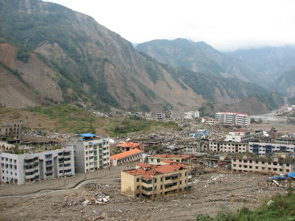
Damage from 2008 Great Sichuan Earthquake in China
The May 12, 2008, Great Sichuan Earthquake, also called the Wenchuan Earthquake, occurred at 14:28 local time, in Sichuan Province, China. The earthquake magnitudes were Mw = 7.9 (USGS), Ms = 8.0 (Chinese Earthquake Administration). The epicenter was 80 km west-northwest of Chengdu, the capital city of Sichuan province.
The May 12, 2008, Great Sichuan Earthquake, also called the Wenchuan Earthquake, occurred at 14:28 local time, in Sichuan Province, China. The earthquake magnitudes were Mw = 7.9 (USGS), Ms = 8.0 (Chinese Earthquake Administration). The epicenter was 80 km west-northwest of Chengdu, the capital city of Sichuan province.

Jianxin
The citizens of Jianxin have already started reconstruction after the 12 May 2008 earthquake.
The citizens of Jianxin have already started reconstruction after the 12 May 2008 earthquake.

Jianxin
An elderly Jianxin woman in her emergency shelter.
An elderly Jianxin woman in her emergency shelter.

Jianxin
A Jianxin shrine damaged in the 12 May 2008 earthquake.
A Jianxin shrine damaged in the 12 May 2008 earthquake.

Jiangyou to Jianxin
Emergency tents have been set up along a roadway that connects Jiangyou and Jianxin.
Emergency tents have been set up along a roadway that connects Jiangyou and Jianxin.

Jiangyou to Jianxin
The emergency tents given to the Chinese after the 12 May 2008 earthquake serve as living spaces for those who cannot stay in their homes.
The emergency tents given to the Chinese after the 12 May 2008 earthquake serve as living spaces for those who cannot stay in their homes.

Jiangyou
Citizens of Jiangyou set up their emergency tents inside a concrete structure after the 12 May 2008 earthquake.
Citizens of Jiangyou set up their emergency tents inside a concrete structure after the 12 May 2008 earthquake.

Zhuyuan
The 12 May 2008 earthquake caused structural damage to these buildings in Zhuyuan.
The 12 May 2008 earthquake caused structural damage to these buildings in Zhuyuan.

Zhuyuan
The 12 May 2008 earthquake reduced this building to a pile of rubble in Zhuyuan.
The 12 May 2008 earthquake reduced this building to a pile of rubble in Zhuyuan.

Malu
Some citizens of Malu had to construct their own tents after the 12 May 2008 earthquake.
Some citizens of Malu had to construct their own tents after the 12 May 2008 earthquake.

Malu
Associated with the 12 May 2008 earthquake, rock and landslides have presented a major problem to the Chinese.
Associated with the 12 May 2008 earthquake, rock and landslides have presented a major problem to the Chinese.

Malu
Japan helped the Chinese in the wake of the 12 May 2008 earthquake.
Japan helped the Chinese in the wake of the 12 May 2008 earthquake.

Malu
A sea of tents with damaged buildings in the background in Malu.
A sea of tents with damaged buildings in the background in Malu.

Zhuyuan
Emergency tents off the side of a road in Zhuyuan were erected after the 12 May 2008 earthquake.
Emergency tents off the side of a road in Zhuyuan were erected after the 12 May 2008 earthquake.