Surface Water Modeling for FEMA Flood Insurance Rate Maps.
USGS employees survey a bridge.

Official websites use .gov
A .gov website belongs to an official government organization in the United States.
Secure .gov websites use HTTPS
A lock () or https:// means you’ve safely connected to the .gov website. Share sensitive information only on official, secure websites.
Images

Surface Water Modeling for FEMA Flood Insurance Rate Maps.
USGS employees survey a bridge.
Surface Water Modeling for FEMA Flood Insurance Rate Maps.
USGS employees survey a bridge.

CB-1072 Niverville NY USGS gage

Florence Bascom joins John Wesley Powell on a 5-day leg of the Powell 150 Expedition, marking the 150th anniversary of the Powell Expedition, an exploration of the Green and Colorado Rivers that ended in the Grand Canyon.
Florence Bascom joins John Wesley Powell on a 5-day leg of the Powell 150 Expedition, marking the 150th anniversary of the Powell Expedition, an exploration of the Green and Colorado Rivers that ended in the Grand Canyon.

Yellow Creek near Oak Grove, IN - view from left bank of site
Yellow Creek near Oak Grove, IN - view from left bank of site

Kanakee River at Davis, IN - gage house side view
Kanakee River at Davis, IN - gage house side view

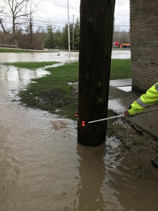
Cuyahoga River at Independence OH - flood water in gage house
Cuyahoga River at Independence OH - flood water in gage house
Cuyahoga River at Independence OH - 2018 high water mark
Cuyahoga River at Independence OH - 2018 high water mark

Highway monitoring station USGS 415157072291301 along State Route 74 near Vernon, Connecticut.
Highway monitoring station USGS 415157072291301 along State Route 74 near Vernon, Connecticut.

Bike path skirting cobbled beaches of Falmouth, Massachusetts.
Bike path skirting cobbled beaches of Falmouth, Massachusetts.

The USGS Ohio Water Microbiology Laboratory addresses water-related public-health concerns and is involved in investigations of processes that affect microorganisms in the environment and testing of new methods to improve detection and interpretation of microbiological presence in water.
The USGS Ohio Water Microbiology Laboratory addresses water-related public-health concerns and is involved in investigations of processes that affect microorganisms in the environment and testing of new methods to improve detection and interpretation of microbiological presence in water.

The USGS Ohio Water Microbiology Laboratory addresses water-related public-health concerns and is involved in investigations of processes that affect microorganisms in the environment and testing of new methods to improve detection and interpretation of microbiological presence in water.
The USGS Ohio Water Microbiology Laboratory addresses water-related public-health concerns and is involved in investigations of processes that affect microorganisms in the environment and testing of new methods to improve detection and interpretation of microbiological presence in water.

Northeast Region Photo Contest Winner | July 2019 | USGS At Work
Colin Sweeny taking field parameters for a water quality sample
Northeast Region Photo Contest Winner | July 2019 | USGS At Work
Colin Sweeny taking field parameters for a water quality sample

Eagle Creek at Zionsville, IN
Eagle Creek at Zionsville, IN

Huron River at Milan, OH - low flow
Huron River at Milan, OH - low flow

HABS platform Owasco Lake, NY

NER May 2019 USGS at Work
Greg Walsh collects data on Coot Hill while conducting geologic mapping in the Adirondacks, NY
NER May 2019 USGS at Work
Greg Walsh collects data on Coot Hill while conducting geologic mapping in the Adirondacks, NY

Yellow Creek near Oak Grove, IN - view from bridge
Yellow Creek near Oak Grove, IN - view from bridge

Yellow Creek near Oak Grove, IN - high flow measurement
Yellow Creek near Oak Grove, IN - high flow measurement

Yellow Creek near Oak Grove, IN - adcp high water measurement
Yellow Creek near Oak Grove, IN - adcp high water measurement

Yellow Creek near Oak Grove, IN - USGS staff making bridge measurement
Yellow Creek near Oak Grove, IN - USGS staff making bridge measurement

Eagle Creek at Zionsville, IN downstream of gage
Eagle Creek at Zionsville, IN downstream of gage