
World map of expected annual disruption of copper refinery production, in metric tons, from potential seismic activity.
Images
Images described and linked on this webpage come from a wide variety of USGS science activities and presentations performed by USGS Science Center staff members in the Region 7: Upper Colorado Basin. A search tool is provided to narrow the number of image files shown.
Filter Total Items: 496

Figure4SeismicCopper.png
World map of expected annual disruption of copper refinery production, in metric tons, from potential seismic activity.

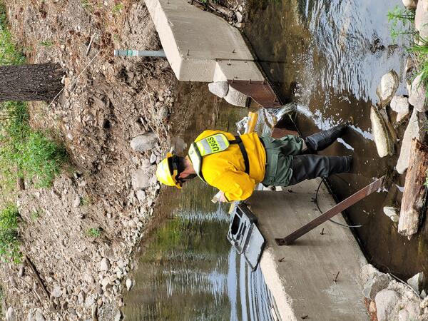
USGS Scientists Deploy to New Mexico Fire to Enhance Water Monitoring
USGS Water and Fire Technicians team members, Jorge Gonzalez and Efren Alvarado, made repairs to the Buck Mountain precipitation gage during the Blue 2 Fire near Alto, New Mexico on June 7, 2024. This station, along with similar gages, provides critical real-time rainfall data to the National Weather Service and local emergency managers.
USGS Water and Fire Technicians team members, Jorge Gonzalez and Efren Alvarado, made repairs to the Buck Mountain precipitation gage during the Blue 2 Fire near Alto, New Mexico on June 7, 2024. This station, along with similar gages, provides critical real-time rainfall data to the National Weather Service and local emergency managers.
Repairing a streamgage during the Blue 2 Fire near Alto, New Mexico
A member of the USGS Water and Fire Technicians Team repairs a streamgage during the Blue 2 Fire near Alto, New Mexico.
A member of the USGS Water and Fire Technicians Team repairs a streamgage during the Blue 2 Fire near Alto, New Mexico.

The USGS Water and Fire Technicians Team prepares to evaluate precipitation and streamflow gauges during the Blue 2 Fire near Alto, New Mexico.
linkThe USGS Water and Fire Technicians Team prepares to evaluate precipitation and streamflow gauges during the Blue 2 Fire near Alto, New Mexico.
The USGS Water and Fire Technicians Team prepares to evaluate precipitation and streamflow gauges during the Blue 2 Fire near Alto, New Mexico.
linkThe USGS Water and Fire Technicians Team prepares to evaluate precipitation and streamflow gauges during the Blue 2 Fire near Alto, New Mexico.

USGS scientist retrieves water quality sensor on the Rio Grande in Albuquerque, New Mexico
USGS scientist Kimberly Beisner retrieves a water quality sensor on the Rio Grande for a PFAS study in Albuquerque, New Mexico.
USGS scientist Kimberly Beisner retrieves a water quality sensor on the Rio Grande for a PFAS study in Albuquerque, New Mexico.

USGS scientists walk into the Rio Grande to collect water samples for a PFAS study near Valle de Oro, New Mexico.
linkUSGS scientists Kimberly Beisner and Keely Miltenberger walk into the Rio Grande to collect water samples for a PFAS study near Valle de Oro, New Mexico.
USGS scientists walk into the Rio Grande to collect water samples for a PFAS study near Valle de Oro, New Mexico.
linkUSGS scientists Kimberly Beisner and Keely Miltenberger walk into the Rio Grande to collect water samples for a PFAS study near Valle de Oro, New Mexico.

Water quality sampler deployed on the Rio Grande in Alameda, New Mexico.
Water quality sampler deployed on the Rio Grande to collect an integrated sample of PFAS in the water in Alameda, New Mexico.
Water quality sampler deployed on the Rio Grande to collect an integrated sample of PFAS in the water in Alameda, New Mexico.

Scientists travel by raft to collect samples in the Grand Canyon
Scientists travel by raft to collect various samples on the Colorado River in the Grand Canyon.
Scientists travel by raft to collect various samples on the Colorado River in the Grand Canyon.

LCR.Virtual.Tribal.Open_.House_.Image_11_29_2023.jpg
Title Slide for Lower Colorado River Basin Panel Discussion for USGS Virtual Open House meeting to discuss drought issues with Native American Tribal Members. Held online via Microsoft Teams on November 29, 2024.
Title Slide for Lower Colorado River Basin Panel Discussion for USGS Virtual Open House meeting to discuss drought issues with Native American Tribal Members. Held online via Microsoft Teams on November 29, 2024.

UCR.Virtual.Tribal.Open_.House_11_29_2023.jpg
Cover slide for USGS Upper Colorado River Basin Panel Discussion Virtual Open House about drought issues with Tribal Representatives, conducted on November 29, 2023 via Microsoft Teams
Cover slide for USGS Upper Colorado River Basin Panel Discussion Virtual Open House about drought issues with Tribal Representatives, conducted on November 29, 2023 via Microsoft Teams

Upper Colorado River Basin streamflow, March-August 2023
March-August daily average streamflow for the last 30 years (1991-2022) (dark gray lines) compared to 2023, showing the periods where 2023 streamflow was above (blue) and below (orange) the historical average. Individual years of the relevant historical streamflow period are shown in light gray.
March-August daily average streamflow for the last 30 years (1991-2022) (dark gray lines) compared to 2023, showing the periods where 2023 streamflow was above (blue) and below (orange) the historical average. Individual years of the relevant historical streamflow period are shown in light gray.

ASIST.Tribal.Open_.House_.A.Oct_.16.2023.jpg
Photograph taken by Jessica Driscoll of USGS ASIST Project Tribal Open House, Tucson, AZ, Oct. 16, 2023
Photograph taken by Jessica Driscoll of USGS ASIST Project Tribal Open House, Tucson, AZ, Oct. 16, 2023

ASIST.Tribal.Open_.House_.B.Oct_.16.2023.jpg
Photograph taken at USGS ASIST Project Tribal Open House, Tucson, AZ, Oct. 16, 2023
Photograph taken at USGS ASIST Project Tribal Open House, Tucson, AZ, Oct. 16, 2023

SIPI.Albuquerque.Tribal.Open_.House_A.Sept_.26.2023.JPG
Photograph taken at USGS ASIST Project Open House related to Drought Issues in Tribal Lands in and near the Colorado River Basin, held at the Southwestern Indian Polytechnic Institute, Albuquerque, New Mexico, September 26, 2023
Photograph taken at USGS ASIST Project Open House related to Drought Issues in Tribal Lands in and near the Colorado River Basin, held at the Southwestern Indian Polytechnic Institute, Albuquerque, New Mexico, September 26, 2023

Panel Discussion at USGS ASIST Project Tribal Drought Issues Open House, Albuquerque, NM, Sept. 26, 2023
linkPhotograph of Panel Discussion at USGS ASIST Project Open House related to Drought Issues in Tribal Lands in and near the Colorado River Basin, held at the Southwestern Indian Polytechnic Institute, Albuquerque, New Mexico, September 26, 2023

Medicine Bow LLFA Survey Map
A map of the airborne geophysical survey area in the Medicine Mountains region of Wyoming
A map of the airborne geophysical survey area in the Medicine Mountains region of Wyoming

Researchers inject fluorescein dye into Lake Fork Creek, Colorado
Researchers inject fluorescein dye into Lake Fork Creek, Colorado, in August 2023. This study aims to trace water flow from the historic Sugarloaf mining district into the creek.
Researchers inject fluorescein dye into Lake Fork Creek, Colorado, in August 2023. This study aims to trace water flow from the historic Sugarloaf mining district into the creek.

Montana
A view of the Boulder Mountains from US-12 west of Helena. These mountains lie at the north end of the Boulder Batholith.
A view of the Boulder Mountains from US-12 west of Helena. These mountains lie at the north end of the Boulder Batholith.

map1fema366.JPG
Map showing distribution of average annualized earthquake loss by region. The high concentration of loss in California and the West Coast is consistent with that region’s high seismic hazard, significant population, and building exposure.
Map showing distribution of average annualized earthquake loss by region. The high concentration of loss in California and the West Coast is consistent with that region’s high seismic hazard, significant population, and building exposure.

map2fema366.JPG
Although most economic loss is concentrated along the west coast, the distribution of relative earthquake risk, as measured by the Annualized Earthquake Loss Ratio (AELR), is spread throughout the country and it reinforces the fact that earthquakes are a national problem.
Although most economic loss is concentrated along the west coast, the distribution of relative earthquake risk, as measured by the Annualized Earthquake Loss Ratio (AELR), is spread throughout the country and it reinforces the fact that earthquakes are a national problem.

National Early Detection and Rapid Response Information Systems Contact Information
National Early Detection and Rapid Response Information Systems Contact Information
National Early Detection and Rapid Response Information Systems Contact Information