

CONUS elevation map in bright, vibrant colors with purple as highest elevation and blue as lowest elevation and the hydrography map with larger annual flow volumes as thicker lines.
Alexander B Jonesi
Alexander Jonesi is a geographer with the Topographic Data Services office of the National Geospatial Program.
Alexander began his professional career interning for the National Institutes of Health (NIH) while pursuing his Bachelor's Degree from the University of Maryland. At the NIEHS, he co-authored a publication entitled Exposure to naturally occurring mineral fibers due to off-road vehicle use: A review. Additionally, Alexander worked for the USGS's Eastern Geographic Science Center (EGSC) as an intern in 2015 and after graduating, continued his work as a contractor working for EGSC and the National Cooperative Geologic Mapping Program (NCGMP) and volunteering with the Office of Science Quality and Integrity (OSQI). He contributed to several projects including a carbon research project at the Great Dismal Swamp, cataloging mangroves at Ding Darling National Wildlife Refuge in Sanibel, FL, and working with the Secondary Transition to Employment Program (STEP), which provides young adults from local high schools with learning disabilities job skills to help them transition from school to work. Following the conclusion of his contract, Alexander worked as a Pathways Student Trainee for the Topographic Data Services (TDS) office of the National Geospatial Program (NGP) while pursuing his Master's in Geospatial Intelligence. Since graduating, Alexander works as a geographer for NGP's TDS office, working with the 3D Elevation Program (3DEP) and 3D Hydrography Program (3DHP).
Science and Products
CONUS Elevation and Hydrography
CONUS elevation map in bright, vibrant colors with purple as highest elevation and blue as lowest elevation and the hydrography map with larger annual flow volumes as thicker lines.
3DEP Quality Data by Collection Year Animated GIF
This animated GIF is a map of the United States and its territories shows geographic extent of planned, existing, and in-progress 3DEP data acquisition projects by year.
This animated GIF is a map of the United States and its territories shows geographic extent of planned, existing, and in-progress 3DEP data acquisition projects by year.
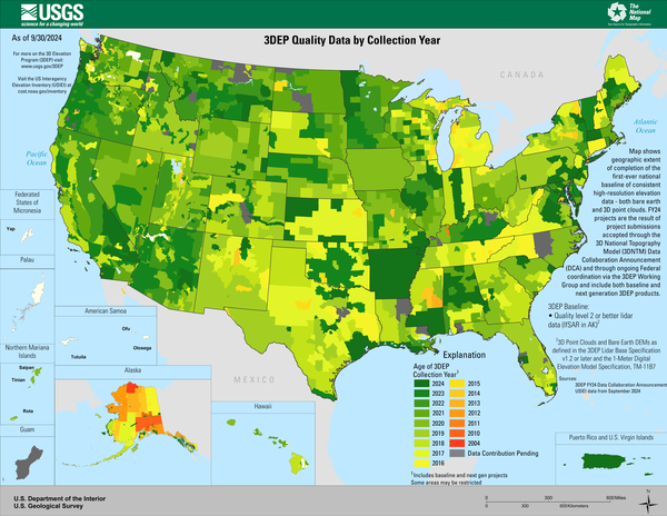
3DEP Quality Data by Collection Year
Map shows geographic extent of completion of the first-ever national baseline of consistent high-resolution elevation data - both bare earth and 3D point clouds.
Map shows geographic extent of completion of the first-ever national baseline of consistent high-resolution elevation data - both bare earth and 3D point clouds.

3DEP Quality Data by Collection Year Animation
3DEP Quality Data by Collection Year
Age of 3DEP
Dark Green: Planned FY23
Light Green - Red: 2022 - 2004
Gray: Data Contribution Pending
3DEP Quality Data by Collection Year
Age of 3DEP
Dark Green: Planned FY23
Light Green - Red: 2022 - 2004
Gray: Data Contribution Pending

3DEP Quality Data by Collection Year
3DEP Quality Data by Collection Year
Age of 3DEP
Dark Green: Planned FY23
Light Green - Red: 2022 - 2004
Gray: Data Contribution Pending
3DEP Quality Data by Collection Year
Age of 3DEP
Dark Green: Planned FY23
Light Green - Red: 2022 - 2004
Gray: Data Contribution Pending

3D Nation Elevation Requirements and Benefits Study Logo
3D Nation Elevation Requirements and Benefits Study LogoThe 3D Nation Elevation Requirements and Benefits Study was performed to document national requirements for improved topographic and bathymetric elevation data, estimate the benefits and costs of meeting these requirements, and evaluate multiple national 3D elevation program implementation scenarios.

Dark Hollow Falls
Dark Hollow Falls - Shenandoah National Park, VA
Dark Hollow Falls - Shenandoah National Park, VA
Science and Products
CONUS Elevation and Hydrography
CONUS elevation map in bright, vibrant colors with purple as highest elevation and blue as lowest elevation and the hydrography map with larger annual flow volumes as thicker lines.
CONUS elevation map in bright, vibrant colors with purple as highest elevation and blue as lowest elevation and the hydrography map with larger annual flow volumes as thicker lines.
3DEP Quality Data by Collection Year Animated GIF
This animated GIF is a map of the United States and its territories shows geographic extent of planned, existing, and in-progress 3DEP data acquisition projects by year.
This animated GIF is a map of the United States and its territories shows geographic extent of planned, existing, and in-progress 3DEP data acquisition projects by year.
3DEP Quality Data by Collection Year
Map shows geographic extent of completion of the first-ever national baseline of consistent high-resolution elevation data - both bare earth and 3D point clouds.
Map shows geographic extent of completion of the first-ever national baseline of consistent high-resolution elevation data - both bare earth and 3D point clouds.
3DEP Quality Data by Collection Year Animation
3DEP Quality Data by Collection Year
Age of 3DEP
Dark Green: Planned FY23
Light Green - Red: 2022 - 2004
Gray: Data Contribution Pending
3DEP Quality Data by Collection Year
Age of 3DEP
Dark Green: Planned FY23
Light Green - Red: 2022 - 2004
Gray: Data Contribution Pending
3DEP Quality Data by Collection Year
3DEP Quality Data by Collection Year
Age of 3DEP
Dark Green: Planned FY23
Light Green - Red: 2022 - 2004
Gray: Data Contribution Pending
3DEP Quality Data by Collection Year
Age of 3DEP
Dark Green: Planned FY23
Light Green - Red: 2022 - 2004
Gray: Data Contribution Pending
3D Nation Elevation Requirements and Benefits Study Logo
3D Nation Elevation Requirements and Benefits Study LogoThe 3D Nation Elevation Requirements and Benefits Study was performed to document national requirements for improved topographic and bathymetric elevation data, estimate the benefits and costs of meeting these requirements, and evaluate multiple national 3D elevation program implementation scenarios.
Dark Hollow Falls
Dark Hollow Falls - Shenandoah National Park, VA
Dark Hollow Falls - Shenandoah National Park, VA