USGS sediment sampling vessel on the Rainy River, Minnesota
USGS sediment sampling vessel on the Rainy River, MinnesotaUSGS scientists aboard a sediment sampling vessel on the Rainy River, Minnesota, preparing for a day of sampling.

Official websites use .gov
A .gov website belongs to an official government organization in the United States.
Secure .gov websites use HTTPS
A lock () or https:// means you’ve safely connected to the .gov website. Share sensitive information only on official, secure websites.
Faith Fitzpatrick is a research hydrologist at the Upper Midwest Water Science Center.
Faith has spent much of her career studying geomorphic, flood, and sediment dynamics of rivers. Her area of expertise is in historical watershed geomorphology and sediment budgets, specifically identifying natural and human causes for accelerated erosion and sedimentation problems, flooding, habitat degradation, eutrophication, and sources of contaminants. Recent work includes interactions of oil and sediment in rivers and geomorphic characterization of Great Lakes estuaries. She works closely with land and water resources and fisheries managers from a variety of agencies in a scientific support role. She is an instructor for the USGS Training Center.


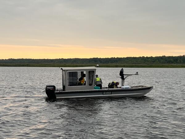
USGS scientists aboard a sediment sampling vessel on the Rainy River, Minnesota, preparing for a day of sampling.
USGS scientists aboard a sediment sampling vessel on the Rainy River, Minnesota, preparing for a day of sampling.
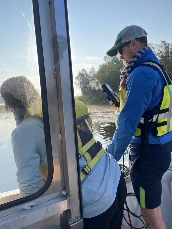
Two USGS scientists measuring water quality along the Rainy River and at its mouth in Four-Mile Bay, Lake of the Woods, Minnesota, to study how phosphorus stored in sediment may be interacting with river water and potentially contributing to problematic algal blooms in Lake of the Woods.
Two USGS scientists measuring water quality along the Rainy River and at its mouth in Four-Mile Bay, Lake of the Woods, Minnesota, to study how phosphorus stored in sediment may be interacting with river water and potentially contributing to problematic algal blooms in Lake of the Woods.

A cross-sectional view of a hypothetical coastline showing one possible arrangement of the three Federal Flood Risk Management Standard (FFRMS) floodplain elevations (Climate-Informed Science Approach, the Freeboard Value Approach, and the 0.2% Annual-Chance Flood Approach) above the current Base Flood Elevation, i.e., the 1% annual-chance flood elevation.
A cross-sectional view of a hypothetical coastline showing one possible arrangement of the three Federal Flood Risk Management Standard (FFRMS) floodplain elevations (Climate-Informed Science Approach, the Freeboard Value Approach, and the 0.2% Annual-Chance Flood Approach) above the current Base Flood Elevation, i.e., the 1% annual-chance flood elevation.

A cross-sectional view of a hypothetical river showing one possible arrangement of the three Federal Flood Risk Management Standard (FFRMS) floodplain elevations (Climate-Informed Science Approach, the Freeboard Value Approach, and the 0.2% Annual-Chance Flood Approach) above the current Base Flood Elevation, i.e., the 1% annual-chance flood elevation.
A cross-sectional view of a hypothetical river showing one possible arrangement of the three Federal Flood Risk Management Standard (FFRMS) floodplain elevations (Climate-Informed Science Approach, the Freeboard Value Approach, and the 0.2% Annual-Chance Flood Approach) above the current Base Flood Elevation, i.e., the 1% annual-chance flood elevation.

A cross-sectional view of a hypothetical river showing one possible arrangement of the three Federal Flood Risk Management Standard (FFRMS) floodplain elevations (Climate-Informed Science Approach, the Freeboard Value Approach, and the 0.2% Annual-Chance Flood Approach) above the current Base Flood Elevation, i.e., the 1% annual-chance flood elevation.
A cross-sectional view of a hypothetical river showing one possible arrangement of the three Federal Flood Risk Management Standard (FFRMS) floodplain elevations (Climate-Informed Science Approach, the Freeboard Value Approach, and the 0.2% Annual-Chance Flood Approach) above the current Base Flood Elevation, i.e., the 1% annual-chance flood elevation.

A cross-sectional view of a hypothetical coastline showing one possible arrangement of the three Federal Flood Risk Management Standard (FFRMS) floodplain elevations (Climate-Informed Science Approach, the Freeboard Value Approach, and the 0.2% Annual-Chance Flood Approach) above the current Base Flood Elevation, i.e., the 1% annual-chance flood elevation.
A cross-sectional view of a hypothetical coastline showing one possible arrangement of the three Federal Flood Risk Management Standard (FFRMS) floodplain elevations (Climate-Informed Science Approach, the Freeboard Value Approach, and the 0.2% Annual-Chance Flood Approach) above the current Base Flood Elevation, i.e., the 1% annual-chance flood elevation.
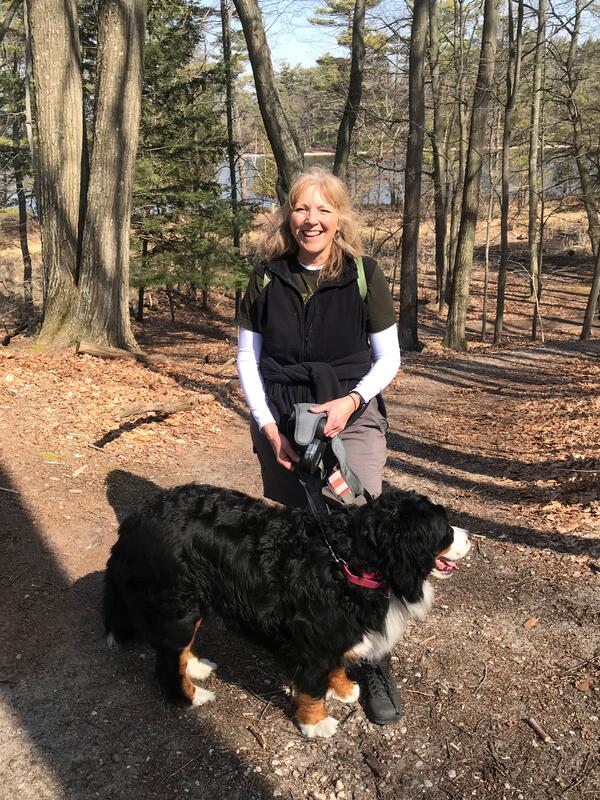
Faith Fitzpatrick taking her Bernese Mountain dog on a hike to check out rock outcrops around southern Wisconsin.
Faith Fitzpatrick taking her Bernese Mountain dog on a hike to check out rock outcrops around southern Wisconsin.
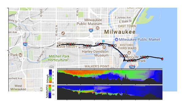
Map of dissolved oxygen and turbidity along the Milwaukee River.
These data are preliminary or provisional and are subject to revision. They are being provided to meet the need for timely best science.
Map of dissolved oxygen and turbidity along the Milwaukee River.
These data are preliminary or provisional and are subject to revision. They are being provided to meet the need for timely best science.
In this photo, USGS scientists Megan Haserodt (Hydrologist) and Jenelle Wempner (Student Intern) install a double ring infiltrometer along a recreated floodplain of Underwood Creek, a tributary to the Milwaukee River and Lake Michigan in Milwaukee, Wisconsin.
In this photo, USGS scientists Megan Haserodt (Hydrologist) and Jenelle Wempner (Student Intern) install a double ring infiltrometer along a recreated floodplain of Underwood Creek, a tributary to the Milwaukee River and Lake Michigan in Milwaukee, Wisconsin.

Bank erosion along an upstream reach of the Kinnickinnic River, October 2018.
Bank erosion along an upstream reach of the Kinnickinnic River, October 2018.

An example stream reach of Underwood Creek’s channel in 2018 after rehabilitation.
An example stream reach of Underwood Creek’s channel in 2018 after rehabilitation.

Milwaukee River Estuary, March 2016

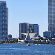
Confluence of inner harbor and the Milwaukee River along North Riverwalk Way, leading into downtown Milwaukee, Wisconsin in early spring.
Confluence of inner harbor and the Milwaukee River along North Riverwalk Way, leading into downtown Milwaukee, Wisconsin in early spring.
USGS scientists aboard a sediment sampling vessel on the Rainy River, Minnesota, preparing for a day of sampling.
USGS scientists aboard a sediment sampling vessel on the Rainy River, Minnesota, preparing for a day of sampling.
Two USGS scientists measuring water quality along the Rainy River and at its mouth in Four-Mile Bay, Lake of the Woods, Minnesota, to study how phosphorus stored in sediment may be interacting with river water and potentially contributing to problematic algal blooms in Lake of the Woods.
Two USGS scientists measuring water quality along the Rainy River and at its mouth in Four-Mile Bay, Lake of the Woods, Minnesota, to study how phosphorus stored in sediment may be interacting with river water and potentially contributing to problematic algal blooms in Lake of the Woods.
A cross-sectional view of a hypothetical coastline showing one possible arrangement of the three Federal Flood Risk Management Standard (FFRMS) floodplain elevations (Climate-Informed Science Approach, the Freeboard Value Approach, and the 0.2% Annual-Chance Flood Approach) above the current Base Flood Elevation, i.e., the 1% annual-chance flood elevation.
A cross-sectional view of a hypothetical coastline showing one possible arrangement of the three Federal Flood Risk Management Standard (FFRMS) floodplain elevations (Climate-Informed Science Approach, the Freeboard Value Approach, and the 0.2% Annual-Chance Flood Approach) above the current Base Flood Elevation, i.e., the 1% annual-chance flood elevation.
A cross-sectional view of a hypothetical river showing one possible arrangement of the three Federal Flood Risk Management Standard (FFRMS) floodplain elevations (Climate-Informed Science Approach, the Freeboard Value Approach, and the 0.2% Annual-Chance Flood Approach) above the current Base Flood Elevation, i.e., the 1% annual-chance flood elevation.
A cross-sectional view of a hypothetical river showing one possible arrangement of the three Federal Flood Risk Management Standard (FFRMS) floodplain elevations (Climate-Informed Science Approach, the Freeboard Value Approach, and the 0.2% Annual-Chance Flood Approach) above the current Base Flood Elevation, i.e., the 1% annual-chance flood elevation.
A cross-sectional view of a hypothetical river showing one possible arrangement of the three Federal Flood Risk Management Standard (FFRMS) floodplain elevations (Climate-Informed Science Approach, the Freeboard Value Approach, and the 0.2% Annual-Chance Flood Approach) above the current Base Flood Elevation, i.e., the 1% annual-chance flood elevation.
A cross-sectional view of a hypothetical river showing one possible arrangement of the three Federal Flood Risk Management Standard (FFRMS) floodplain elevations (Climate-Informed Science Approach, the Freeboard Value Approach, and the 0.2% Annual-Chance Flood Approach) above the current Base Flood Elevation, i.e., the 1% annual-chance flood elevation.
A cross-sectional view of a hypothetical coastline showing one possible arrangement of the three Federal Flood Risk Management Standard (FFRMS) floodplain elevations (Climate-Informed Science Approach, the Freeboard Value Approach, and the 0.2% Annual-Chance Flood Approach) above the current Base Flood Elevation, i.e., the 1% annual-chance flood elevation.
A cross-sectional view of a hypothetical coastline showing one possible arrangement of the three Federal Flood Risk Management Standard (FFRMS) floodplain elevations (Climate-Informed Science Approach, the Freeboard Value Approach, and the 0.2% Annual-Chance Flood Approach) above the current Base Flood Elevation, i.e., the 1% annual-chance flood elevation.
Faith Fitzpatrick taking her Bernese Mountain dog on a hike to check out rock outcrops around southern Wisconsin.
Faith Fitzpatrick taking her Bernese Mountain dog on a hike to check out rock outcrops around southern Wisconsin.
Map of dissolved oxygen and turbidity along the Milwaukee River.
These data are preliminary or provisional and are subject to revision. They are being provided to meet the need for timely best science.
Map of dissolved oxygen and turbidity along the Milwaukee River.
These data are preliminary or provisional and are subject to revision. They are being provided to meet the need for timely best science.
In this photo, USGS scientists Megan Haserodt (Hydrologist) and Jenelle Wempner (Student Intern) install a double ring infiltrometer along a recreated floodplain of Underwood Creek, a tributary to the Milwaukee River and Lake Michigan in Milwaukee, Wisconsin.
In this photo, USGS scientists Megan Haserodt (Hydrologist) and Jenelle Wempner (Student Intern) install a double ring infiltrometer along a recreated floodplain of Underwood Creek, a tributary to the Milwaukee River and Lake Michigan in Milwaukee, Wisconsin.
Bank erosion along an upstream reach of the Kinnickinnic River, October 2018.
Bank erosion along an upstream reach of the Kinnickinnic River, October 2018.
An example stream reach of Underwood Creek’s channel in 2018 after rehabilitation.
An example stream reach of Underwood Creek’s channel in 2018 after rehabilitation.
Milwaukee River Estuary, March 2016
Confluence of inner harbor and the Milwaukee River along North Riverwalk Way, leading into downtown Milwaukee, Wisconsin in early spring.
Confluence of inner harbor and the Milwaukee River along North Riverwalk Way, leading into downtown Milwaukee, Wisconsin in early spring.