
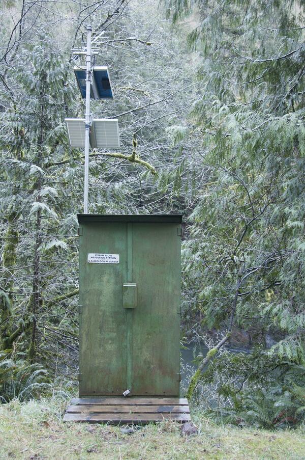
A U.S. Geological Survey streamflow gaging station collects water data on the Trask River. The Trask River gage is located near Tillamook, Ore. and has been in operation for 17 years.
Images
Explore images.
Filter Total Items: 701
A USGS streamflow gaging station is used to collect water data
A U.S. Geological Survey streamflow gaging station collects water data on the Trask River. The Trask River gage is located near Tillamook, Ore. and has been in operation for 17 years.

USGS streamgage on the Trask River
Trask River stage, discharge, and water-quality data are collected and used together to help monitor the current health of the river. Data from the river are sent to equipment in the gage house, where it is stored then transmitted to USGS servers.
Trask River stage, discharge, and water-quality data are collected and used together to help monitor the current health of the river. Data from the river are sent to equipment in the gage house, where it is stored then transmitted to USGS servers.

Red spotted toad.
Red spotted toad.

A mangy wolf in Yellowstone National Park.

Mount St. Helens 2014 Teacher Workshop
Flyer for the Mount St. Helens Teacher Workshop. Held June 25-27, 2014, it was a workshop for middle school teachers.
Flyer for the Mount St. Helens Teacher Workshop. Held June 25-27, 2014, it was a workshop for middle school teachers.

Elwha River flowing through former dam site during flood
USGS Hydrologist Chris Magirl captures image of the Elwha River flooding for the first time following dam removal. This location is just downstream of the former Elwha Dam which used to stand at the area near the top of the photograph.
USGS Hydrologist Chris Magirl captures image of the Elwha River flooding for the first time following dam removal. This location is just downstream of the former Elwha Dam which used to stand at the area near the top of the photograph.

Pend Oreille River in winter
The Kalispel Tribe in northeastern Washington is located along the Pend Oreille River, home to culturally important, cold-water fish, such as bull trout and cutthroat trout.
The Kalispel Tribe in northeastern Washington is located along the Pend Oreille River, home to culturally important, cold-water fish, such as bull trout and cutthroat trout.

USGS scientist waits for helicopter pick-up in Mount St. Helens crater
USGS-CVO Research Geologist Peter Kelly communicates with the helicopter pilot and prepares for pick-up, on the new dome within the crater of Mount St. Helens.
USGS-CVO Research Geologist Peter Kelly communicates with the helicopter pilot and prepares for pick-up, on the new dome within the crater of Mount St. Helens.

Glines Canyon East Abutment
Visitors at Glines Canyon East Abutment in Olympic National Park, the location of the Elwha River Restoration project. Image available at Olympic National Park flickr site.
Visitors at Glines Canyon East Abutment in Olympic National Park, the location of the Elwha River Restoration project. Image available at Olympic National Park flickr site.

Specific-Pathogen-Free Pacific herring
Different size and age classes of experimental Specific-Pathogen-Free Pacific herring reared at the Marrowstone Marine Field Station.
Different size and age classes of experimental Specific-Pathogen-Free Pacific herring reared at the Marrowstone Marine Field Station.

Locate groundwater at Mount St. Helens
USGS researcher Jeff Wynn monitors in-coming data at the CSAMT (Controlled-Source Audio-Magnetotellurics ) receiver site on Mount St. Helens. The data will be used to locate the top of the groundwater system beneath the site.
USGS researcher Jeff Wynn monitors in-coming data at the CSAMT (Controlled-Source Audio-Magnetotellurics ) receiver site on Mount St. Helens. The data will be used to locate the top of the groundwater system beneath the site.

Elwha River mouth during dam removal
Aerial photograph of the mouth of the Elwha River showing sediment deposits from dam removal. Aerial assistance by LightHawk and plane piloted by Dr. Milton Bennett.
Aerial photograph of the mouth of the Elwha River showing sediment deposits from dam removal. Aerial assistance by LightHawk and plane piloted by Dr. Milton Bennett.

Glines Canyon Dam removal
Aerial photograph of the Elwha River flowing through the remains of the Glines Canyon Dam during the 3rd year of the dam removal project. Aerial assistance by LightHawk and plane piloted by Dr. Milton Bennett.
Aerial photograph of the Elwha River flowing through the remains of the Glines Canyon Dam during the 3rd year of the dam removal project. Aerial assistance by LightHawk and plane piloted by Dr. Milton Bennett.

MultiGAS monitoring station inside crater of Mount St. Helens
The new volcanic-gas monitoring station installed at Mount St. Helens consists of weather monitoring equipment and sensors for measuring the concentrations of water vapor (H2O), carbon dioxide (CO2), sulfur dioxide (SO2), and hydrogen sulfide (H2S) in volcanic gas plumes.
The new volcanic-gas monitoring station installed at Mount St. Helens consists of weather monitoring equipment and sensors for measuring the concentrations of water vapor (H2O), carbon dioxide (CO2), sulfur dioxide (SO2), and hydrogen sulfide (H2S) in volcanic gas plumes.

Taking kidney samples from adult female Chinook salmon
Connie McKibben and Carla Conway (USGS) taking kidney samples from adult female Chinook salmon for detection and quantification of Renibacterium salmoninarum (Rs) in the fish, while Joy Evered observes. Dr. Evered is a USFWS Veterinary Medical Officer and the USFWS Project Officer for this research project.
Connie McKibben and Carla Conway (USGS) taking kidney samples from adult female Chinook salmon for detection and quantification of Renibacterium salmoninarum (Rs) in the fish, while Joy Evered observes. Dr. Evered is a USFWS Veterinary Medical Officer and the USFWS Project Officer for this research project.

Upper Whitehorse Creek stream water runs underground
A crew surveys Upper Whitehorse Creek in SE Oregon and finds a stretch of stream that dries up, or runs underground.
A crew surveys Upper Whitehorse Creek in SE Oregon and finds a stretch of stream that dries up, or runs underground.

Recording data for female spring Chinook salmon
Dr. Wendy Olson, USFWS biologist (orange rain pants) records data for female spring Chinook salmon being spawned at the hatchery. Among the data recorded are fin clips designating treatment groups for the research project (erythromycin treatment, tulathromycin treatment, or no treatment).
Dr. Wendy Olson, USFWS biologist (orange rain pants) records data for female spring Chinook salmon being spawned at the hatchery. Among the data recorded are fin clips designating treatment groups for the research project (erythromycin treatment, tulathromycin treatment, or no treatment).

The confluence of the Suiattle River (muddy river) into the Sauk River
The confluence of the Suiattle River (muddy river) into the Sauk River.
The confluence of the Suiattle River (muddy river) into the Sauk River.

Installation of two 20' PIT tag antennas
Installation of two 20' PIT tag antennas. Antennas are used to monitor movements of Lost River and shortnose suckers and Redband trout through the Klamath Basin.
Installation of two 20' PIT tag antennas. Antennas are used to monitor movements of Lost River and shortnose suckers and Redband trout through the Klamath Basin.

Spotted Owl
Northern spotted owls (Strix occidentalis caurina) are mostly non-migratory, long-lived birds whose populations have declined in mature forests of western North America.
Northern spotted owls (Strix occidentalis caurina) are mostly non-migratory, long-lived birds whose populations have declined in mature forests of western North America.

Northern spotted Owl
Spotted Owl flying
Spotted Owl flying