
The sun rises at Mount St. Helens (pictured in the distance), with low-level clouds covering Coldwater Lake. The view is from the Coldwater Science and Learning Center, the site of the 2018 GeoGirls field camp program.
Images
Explore images.
Filter Total Items: 701

Sunrise at Mount St. Helens
The sun rises at Mount St. Helens (pictured in the distance), with low-level clouds covering Coldwater Lake. The view is from the Coldwater Science and Learning Center, the site of the 2018 GeoGirls field camp program.

Diversion web cam on the Elwha River
Web cam mounted near USGS gaging station site number 12046260, looking upstream from the water supply diversion structure on the lower Elwha River near Port Angeles in Washington.
Web cam mounted near USGS gaging station site number 12046260, looking upstream from the water supply diversion structure on the lower Elwha River near Port Angeles in Washington.

Flushing stomach contents from a live resident Chinook salmon
Flushing stomach contents from a live resident Chinook salmon for an investigation of cannibalism and predation impacts.
Flushing stomach contents from a live resident Chinook salmon for an investigation of cannibalism and predation impacts.

USGS hydrologic technicians train Kootenai Tribe of Idaho staff
USGS hydrologic technicians Keith Hein and Pete Elliott explain site selection and operation of USGS streamgages to staff members of the Kootenai Tribe of Idaho's Fish and Wildlife Department at streamgage station 12310100, Kootenai River at Tribal Hatchery near Bonners Ferry, Idaho.
USGS hydrologic technicians Keith Hein and Pete Elliott explain site selection and operation of USGS streamgages to staff members of the Kootenai Tribe of Idaho's Fish and Wildlife Department at streamgage station 12310100, Kootenai River at Tribal Hatchery near Bonners Ferry, Idaho.
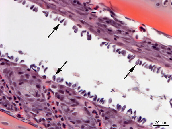
Gills from Lost River Suckers - heavy infestation of Ichthyobodo sp.
Gills from Lost River suckers with a heavy infestation of Ichthyobodo sp. (arrows). Slide is stained with hematoxylin and eosin.
Gills from Lost River suckers with a heavy infestation of Ichthyobodo sp. (arrows). Slide is stained with hematoxylin and eosin.

Herring (top) and juvenile Chinook salmon (bottom)
Herring (top) and juvenile Chinook salmon (bottom) flushed from the stomach of a resident Chinook salmon in Puget Sound.
Herring (top) and juvenile Chinook salmon (bottom) flushed from the stomach of a resident Chinook salmon in Puget Sound.

Heading back to port, Newport Harbor
Entering Yaquina Bay, Oregon aboard the NOAA ship Rainier, approaching the Yaquina Bay Bridge with Newport Marina off to the right in the distance.
Entering Yaquina Bay, Oregon aboard the NOAA ship Rainier, approaching the Yaquina Bay Bridge with Newport Marina off to the right in the distance.

Using drones to study groundwater
Did you know that plants can help us understand what is happening underground? Studying plants in an area can sometimes provide information about soil conditions, water availability, and water quality.
Did you know that plants can help us understand what is happening underground? Studying plants in an area can sometimes provide information about soil conditions, water availability, and water quality.

Using drones to study groundwater
Did you know that plants can sometimes help us understand what is happening underground? Studying plants in an area can provide information about soil conditions, water availability, and water quality.
Did you know that plants can sometimes help us understand what is happening underground? Studying plants in an area can provide information about soil conditions, water availability, and water quality.

Figure 1 from Miller, et al, 2018
Map highlighting sampling locations of 339 Northern Spotted Owls used in Miller, et al, 2018
Map highlighting sampling locations of 339 Northern Spotted Owls used in Miller, et al, 2018

GeoGirls_Sediment2
GeoGirls analyze volcanic sediment at the Coldwater Lake outlet.
GeoGirls analyze volcanic sediment at the Coldwater Lake outlet.

GeoGirls_Core
GeoGirls take core samples at a pond near the Hummocks Trail to study groundwater transport.
GeoGirls take core samples at a pond near the Hummocks Trail to study groundwater transport.

GeoGirls Examing Tephra Deposits
The GeoGirls examined tephra (ash and pumice) deposits from Mount St. Helens’ eruptive past and learned how to create a stratigraphic column.
The GeoGirls examined tephra (ash and pumice) deposits from Mount St. Helens’ eruptive past and learned how to create a stratigraphic column.

Elwha River delta mapping
Diana McCandless of the Washington State Department of Ecology pauses for a moment, on the beach around the point and to the east of the mouth of Elwha River. McCandless is part of a team of scientists from WA State and the USGS who are periodically mapping the delta and beach areas near the mouth of the Elwha River.
Diana McCandless of the Washington State Department of Ecology pauses for a moment, on the beach around the point and to the east of the mouth of Elwha River. McCandless is part of a team of scientists from WA State and the USGS who are periodically mapping the delta and beach areas near the mouth of the Elwha River.

Synchronized mapping
USGS and Washington State Department of Ecology scientists are geared up and ready to start a topographic survey at the mouth of the Elwha River, using handheld computers and backpack-mounted GPS equipment. From left to right are Owen Warrick (USGS Volunteer), Jon Warrick (USGS), Andy Ritchie (USGS), Heather Weiner (WA State Dept.
USGS and Washington State Department of Ecology scientists are geared up and ready to start a topographic survey at the mouth of the Elwha River, using handheld computers and backpack-mounted GPS equipment. From left to right are Owen Warrick (USGS Volunteer), Jon Warrick (USGS), Andy Ritchie (USGS), Heather Weiner (WA State Dept.

Nested polymerase chain reaction (nPCR) for the detection of Rs
Nested polymerase chain reaction (nPCR) for the detection of Renibacterium salmoninarum. Agarose gel electrophoresis is used for size separation and visualization of amplified DNA sequences.
Nested polymerase chain reaction (nPCR) for the detection of Renibacterium salmoninarum. Agarose gel electrophoresis is used for size separation and visualization of amplified DNA sequences.

Whidbey Island snapshot west
A pair of video cameras overlook the coast along a beach on Whidbey Island, Island County at the northern boundary of Puget Sound in western Washington. View looks west out into the Strait of Juan de Fuca.
A pair of video cameras overlook the coast along a beach on Whidbey Island, Island County at the northern boundary of Puget Sound in western Washington. View looks west out into the Strait of Juan de Fuca.
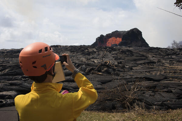
A volcanologist observes a lava fountain during the 2018 Kilauea eruption
U.S. Geological Survey Volcanologist Matthew Patrick photographs and observes a lava fountain in the Leilani Estates near Hilo, Hawai`i on Sunday, May 27, 2018.
U.S. Geological Survey Volcanologist Matthew Patrick photographs and observes a lava fountain in the Leilani Estates near Hilo, Hawai`i on Sunday, May 27, 2018.

Bald Eagle in Washington
I spy with my little (eagle-) eye . . .
After a successful beach survey and installation of remote-sensing cameras on a nearby island, scientists Shawn Harrison and Andrew Stevens spotted this bald eagle near the mouth of the Skagit River, Washington.
I spy with my little (eagle-) eye . . .
After a successful beach survey and installation of remote-sensing cameras on a nearby island, scientists Shawn Harrison and Andrew Stevens spotted this bald eagle near the mouth of the Skagit River, Washington.

Beach on Whidbey Island
View of beach on Whidbey Island, looking south.
View of beach on Whidbey Island, looking south.

Beach on Whidbey Island
View of beach on Whidbey Island, looking north.
View of beach on Whidbey Island, looking north.