
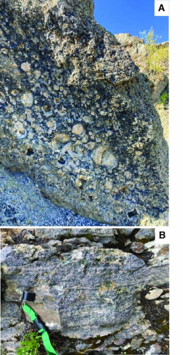
Rhyolite lava flow textures from Long Valley and Yellowstone calderas. A) Photograph of well-developed spherulites in a lava flow from Long Valley Caldera in Eastern California. This high-silica rhyolite flow is very similar to the Central Plateau Member rhyolites of the Yellowstone Plateau Volcanic Field and exhibits many of the same textures.
Multimedia
Images
Rhyolite lava flow textures from Long Valley and Yellowstone calderas
Rhyolite lava flow textures from Long Valley and Yellowstone calderas. A) Photograph of well-developed spherulites in a lava flow from Long Valley Caldera in Eastern California. This high-silica rhyolite flow is very similar to the Central Plateau Member rhyolites of the Yellowstone Plateau Volcanic Field and exhibits many of the same textures.

Large spherulites in Hot Creek rhyolite lava in the Long Valley Caldera
The presence of spherulites indicates that a lava flow cooled quickly, and their mineralogy holds clues to its precise cooling history. USGS photo by Jessica Ball
The presence of spherulites indicates that a lava flow cooled quickly, and their mineralogy holds clues to its precise cooling history. USGS photo by Jessica Ball

Panoramic view of the Long Valley Caldera from its north side
This panorama of the Long Valley Caldera, looking from north to south, shows its broad central plain, post-caldera rhyolite flows and uplift on the right, and eastern Sierra Nevada in the background. USGS photo by Jessica Ball.
This panorama of the Long Valley Caldera, looking from north to south, shows its broad central plain, post-caldera rhyolite flows and uplift on the right, and eastern Sierra Nevada in the background. USGS photo by Jessica Ball.

Eddy covariance station at Mammoth Mountain, California
Photograph of permanent eddy covariance station installed since 2014 in area of volcanic CO2 emissions on Mammoth Mountain, California. USGS photo by Jennifer Lewicki, August 2019.
Photograph of permanent eddy covariance station installed since 2014 in area of volcanic CO2 emissions on Mammoth Mountain, California. USGS photo by Jennifer Lewicki, August 2019.

Simplified geologic map (left) and diagrammatic cross section (right) of Long Valley Caldera.
Simplified geologic map (left) and diagrammatic cross section (right) of Long Valley Caldera. The resurgent dome, Doe Ridge, Mammoth Mountain, and the Inyo Craters and Domes all reflect volcanic activity since 760,000 years ago, when a giant eruption formed the caldera.
Simplified geologic map (left) and diagrammatic cross section (right) of Long Valley Caldera. The resurgent dome, Doe Ridge, Mammoth Mountain, and the Inyo Craters and Domes all reflect volcanic activity since 760,000 years ago, when a giant eruption formed the caldera.

Long Valley Caldera map
Map showing distribution of Long Valley postcaldera rhyolites. Abbreviations: CD, Casa Diablo geothermal plant; Ski area, Mammoth Mountain Ski Area; LVEW, Long Valley Exploratory Well, 3 km deep, located high on resurgent uplift; s, surficial deposits filling structural lows on resurgent uplift.
Map showing distribution of Long Valley postcaldera rhyolites. Abbreviations: CD, Casa Diablo geothermal plant; Ski area, Mammoth Mountain Ski Area; LVEW, Long Valley Exploratory Well, 3 km deep, located high on resurgent uplift; s, surficial deposits filling structural lows on resurgent uplift.