
3DEP lidar rendering of Millsite Reservoir near Millsite State Park, Utah.
Images
The 3DEP Multimedia Gallery is a collection of graphics related to elevation data. All items in this gallery are considered public domain unless otherwise noted.
Filter Total Items: 111

3DEP lidar over Millsite Reservoir, UT
3DEP lidar rendering of Millsite Reservoir near Millsite State Park, Utah.

3DEP Funding Gap Scenarios
Bar graphs comparing three partner funding scenarios for completing nationwide 3D Elevation Program data acquisition by 2023.
Bar graphs comparing three partner funding scenarios for completing nationwide 3D Elevation Program data acquisition by 2023.

GeoDAWN: Geoscience Data Acquisition for Western Nevada
The USGS Earth Mapping Resources Initiative and USGS 3D Elevation Program (3DEP), Department of Energy Geothermal Technologies Office, Natural Resources Conservation Services, and Bureau of Land Management have partnered to conduct airborne geophysical and 3DEP lidar surveys over parts of Nevada and California to collect information on undiscovered geothermal, criti
The USGS Earth Mapping Resources Initiative and USGS 3D Elevation Program (3DEP), Department of Energy Geothermal Technologies Office, Natural Resources Conservation Services, and Bureau of Land Management have partnered to conduct airborne geophysical and 3DEP lidar surveys over parts of Nevada and California to collect information on undiscovered geothermal, criti

Geiger mode lidar over Chicago, IL
Geiger mode 3DEP lidar point cloud over Chicago, IL from 3DEP Project USGS Lidar Point Cloud IL 4County Cook 2017
Geiger mode 3DEP lidar point cloud over Chicago, IL from 3DEP Project USGS Lidar Point Cloud IL 4County Cook 2017

3DEP DEM Viewer Visualizations Wheeler Peak , New Mexico (NM)
The USGS 3DEP DEM viewer may be accessed at: https://apps.nationalmap.gov/3depdem
Left to right:
Aspect
The USGS 3DEP DEM viewer may be accessed at: https://apps.nationalmap.gov/3depdem
Left to right:
Aspect
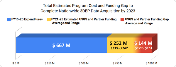
Total Estimated Program Cost and Funding Gap to Complete Nationwide 3D
Bar graph showing total estimated program cost and funding gap to complete nationwide 3D Elevation Program data acquisition by 2023
Bar graph showing total estimated program cost and funding gap to complete nationwide 3D Elevation Program data acquisition by 2023

3DEP Lidar Rendering of Grand Teton National Park
This is a 3DEP lidar digital rendering of Grand Teton National Park.
This is a 3DEP lidar digital rendering of Grand Teton National Park.

Cook County, IL Lidar
This is a geiger mode lidar image colored by elevation over Cook County, Illinois
This is a geiger mode lidar image colored by elevation over Cook County, Illinois

Lidar Point Cloud USGS Headquarters Reston Image Symbology
Lidar point cloud image of USGS headquarters building in Reston, VA, shaded by RGB values from orthophotos
Lidar point cloud image of USGS headquarters building in Reston, VA, shaded by RGB values from orthophotos

Lidar Point Cloud USGS Headquarters Reston Elevation Symbology
Lidar point cloud image of USGS headquarters building in Reston, VA, shaded by elevation
Lidar point cloud image of USGS headquarters building in Reston, VA, shaded by elevation

DEM Stoney Creek Area, VA
"Old Hickory" is a prospect deposit site discovered in 1988 in the Appalachian Highlands of Virginia. DEM Shows the Stoney Creek area, with 5x vertical exaggeration.
"Old Hickory" is a prospect deposit site discovered in 1988 in the Appalachian Highlands of Virginia. DEM Shows the Stoney Creek area, with 5x vertical exaggeration.

3DEP, Lidar point cloud, Pre-Hurricane Maria
Figure 2: Zooming in to red rectangle A from figure 1. Points colored by laser intensity (blue = low intensity, red = high intensity).
Figure 2: Zooming in to red rectangle A from figure 1. Points colored by laser intensity (blue = low intensity, red = high intensity).
Lidar point cloud, Pre-Hurricane PR, rotate and zoom
Figure 3: Zooming in and rotating scene in 3D from figure 2. Points coloer by laser intensity (blue = low intensity, red = high intensity).
Figure 3: Zooming in and rotating scene in 3D from figure 2. Points coloer by laser intensity (blue = low intensity, red = high intensity).

Mt. Kīlauea - July 2018
This image shows a lidar flight done in July 2018 of the Kīlauea volcano after the collapse of the caldera
This image shows a lidar flight done in July 2018 of the Kīlauea volcano after the collapse of the caldera

A 3DEP Image of Alaska's Denali Mountain
An oblique perspective of Alaska's Denali Mountain visualized by 3D Elevation Program lidar data.
An oblique perspective of Alaska's Denali Mountain visualized by 3D Elevation Program lidar data.

3D rendering Great Sand Dunes
3D rendering of Great Sand Dunes National Park and Preserve, from 3DEP DEMs
3D rendering of Great Sand Dunes National Park and Preserve, from 3DEP DEMs

Lidar point cloud of the Statue of Liberty
This image is a lidar point cloud of the Statue of Liberty in New York with a blue to red color ramp symbology with blue representing low elevation, and red representing high elevation
This image is a lidar point cloud of the Statue of Liberty in New York with a blue to red color ramp symbology with blue representing low elevation, and red representing high elevation

3D rendering of Mesa County landslide from 3DEP lidar
3D rendering of Mesa County, Colorado landslide from 3DEP lidar. Lidar point cloud with color from imagery.
3D rendering of Mesa County, Colorado landslide from 3DEP lidar. Lidar point cloud with color from imagery.

Digital Elevation Model of Bitterroot National Forest
A Digital Elevation Model (DEM) of a section of Bitterroot National Forest.
A Digital Elevation Model (DEM) of a section of Bitterroot National Forest.

3D Lidar Rendering of Central Valley, CA
3D lidar point cloud rendering of an agricultural area based on 2017 California Central Valley lidar data.
3D lidar point cloud rendering of an agricultural area based on 2017 California Central Valley lidar data.

Lidar Point Cloud of Washington DC
A lidar point cloud of the National Mall, Washington, D.C. Photograph Credit: Jason Stoker, USGS
A lidar point cloud of the National Mall, Washington, D.C. Photograph Credit: Jason Stoker, USGS