
USGS hydrologist Hannah Richardson prepares to collect a groundwater-level measurement from a well on Idaho's Camas Prairie as part of a groundwater synoptic survey, April 10, 2025. The headwaters of Lava Creek can be seen in the distance.
Images
Images intro.
Filter Total Items: 142

Groundwater-level synoptic, Camas Prairie, Idaho, April 2025
USGS hydrologist Hannah Richardson prepares to collect a groundwater-level measurement from a well on Idaho's Camas Prairie as part of a groundwater synoptic survey, April 10, 2025. The headwaters of Lava Creek can be seen in the distance.
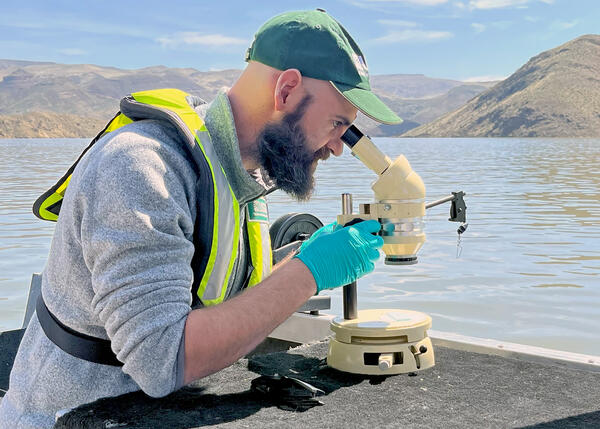
Water-quality reconnaissance of Owyhee Reservoir, eastern Oregon
Research hydrologist Tyler King of the U.S. Geological Survey's Hydrologic Remote Sensing Branch examines a water sample collected from Owyhee Reservoir in eastern Oregon, April 10, 2025. King and scientists from the U.S.
Research hydrologist Tyler King of the U.S. Geological Survey's Hydrologic Remote Sensing Branch examines a water sample collected from Owyhee Reservoir in eastern Oregon, April 10, 2025. King and scientists from the U.S.
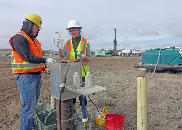
Groundwater monitoring at the Idaho National Laboratory
Austin Taylor and Allison Trcka of the USGS Idaho Water Science Center's Idaho National Laboratory Project Office collect water samples from monitoring well USGS 111 at the Idaho National Laboratory in southeastern Idaho.
Austin Taylor and Allison Trcka of the USGS Idaho Water Science Center's Idaho National Laboratory Project Office collect water samples from monitoring well USGS 111 at the Idaho National Laboratory in southeastern Idaho.

Water-quality sampling on the Coeur d'Alene River, northern Idaho
USGS hydrologic technicians Niko Parrish and Nick Korzen collect data and water samples from the Coeur d'Alene River as part of ongoing water-quality monitoring the USGS Idaho Water Science Center conducts in cooperation with the U.S. Environmental Protection Agency.
USGS hydrologic technicians Niko Parrish and Nick Korzen collect data and water samples from the Coeur d'Alene River as part of ongoing water-quality monitoring the USGS Idaho Water Science Center conducts in cooperation with the U.S. Environmental Protection Agency.

Water-quality sampling in the Coeur d'Alene River Basin, Idaho
U.S. Geological Survey hydrologic technician Niko Parrish collects a water sample from Ninemile Creek at Wallace, Idaho, as part of ongoing water-quality monitoring conducted by the USGS Idaho Water Science Center in the Coeur d'Alene River Basin in cooperation with the U.S. Environmental Protection Agency.
U.S. Geological Survey hydrologic technician Niko Parrish collects a water sample from Ninemile Creek at Wallace, Idaho, as part of ongoing water-quality monitoring conducted by the USGS Idaho Water Science Center in the Coeur d'Alene River Basin in cooperation with the U.S. Environmental Protection Agency.

Measuring Streamflow on Warm Springs Creek near Mackay, Idaho
USGS hydrologic technician Aliesha Bradford measures streamflow on Warm Springs Creek near Mackay, Idaho. Photo by Ryan Moore, USGS.
USGS hydrologic technician Aliesha Bradford measures streamflow on Warm Springs Creek near Mackay, Idaho. Photo by Ryan Moore, USGS.

USGS Idaho Water Science Center hydrologists brief Northwest-Pacific Islands Regional Director Jill Rolland at Crystal Springs along the Snake River
linkDr. Jill Rolland, Director of the USGS Northwest- Pacific Islands Region, visited Idaho during the week of September 23, 2024. During her visit, Dr.

USGS streamgage 13132513, INL Diversion at Head near Arco, Idaho
U.S. Geological Survey monitoring location 13132513, INL Diversion at Head near Arco, Idaho, on the U.S. Department of Energy's Idaho National Laboratory. This view looks south toward Big Southern Butte.
U.S. Geological Survey monitoring location 13132513, INL Diversion at Head near Arco, Idaho, on the U.S. Department of Energy's Idaho National Laboratory. This view looks south toward Big Southern Butte.

2024 Treasure Valley Watershed Watch
U.S. Geological Survey research hydrologist Tyler King helps students from Boise's Pierce Park Elementary School identify aquatic macroinvertebrates as part of the 2024 Watershed Watch educational outreach event along the Boise River in Boise, Idaho.
U.S. Geological Survey research hydrologist Tyler King helps students from Boise's Pierce Park Elementary School identify aquatic macroinvertebrates as part of the 2024 Watershed Watch educational outreach event along the Boise River in Boise, Idaho.

Fish dissection for histopathology analyses
Dr. Cheyenne Smith of the USGS Eastern Ecological Science Center coaches USGS Idaho Water Science Center hydrologic technician Niko Parrish in dissecting a mountain whitefish from northern Idaho's Kootenai River. The samples for histopathology analyses were collected as part of monitoring and assessment of water quality in the transboundary Kootenai River basin.
Dr. Cheyenne Smith of the USGS Eastern Ecological Science Center coaches USGS Idaho Water Science Center hydrologic technician Niko Parrish in dissecting a mountain whitefish from northern Idaho's Kootenai River. The samples for histopathology analyses were collected as part of monitoring and assessment of water quality in the transboundary Kootenai River basin.

Lake Fork Payette River near McCall, Idaho
The Lake Fork Payette River near McCall, Idaho, reached a new peak streamflow on June 3, 2024, overflowing its banks and partially flooding a nearby road. Hydrologic technicians from the USGS Idaho Water Science Center's Boise Field Office responded to collect streamflow measurements. USGS streamgage station 13240000 can be seen at right.
The Lake Fork Payette River near McCall, Idaho, reached a new peak streamflow on June 3, 2024, overflowing its banks and partially flooding a nearby road. Hydrologic technicians from the USGS Idaho Water Science Center's Boise Field Office responded to collect streamflow measurements. USGS streamgage station 13240000 can be seen at right.

Flood Information Sign, Portneuf River at Pocatello, Idaho
Flood information sign installed near U.S. Geological Survey streamgage station 13075500, Portneuf River at Pocatello, Idaho. The sign was developed by the Idaho Silver Jackets interagency flood risk management team. The USGS Idaho Water Science Center is a charter member of the Idaho Silver Jackets.
Flood information sign installed near U.S. Geological Survey streamgage station 13075500, Portneuf River at Pocatello, Idaho. The sign was developed by the Idaho Silver Jackets interagency flood risk management team. The USGS Idaho Water Science Center is a charter member of the Idaho Silver Jackets.

Mountain Home Plateau, Southern Idaho
Panoramic image of the Mountain Home Plateau, southern Idaho. Hydrologists from the USGS Idaho Water Science Center, in cooperation with the Idaho Department of Water Resources, assessed the water resources of the plateau to help improve resource management.
Panoramic image of the Mountain Home Plateau, southern Idaho. Hydrologists from the USGS Idaho Water Science Center, in cooperation with the Idaho Department of Water Resources, assessed the water resources of the plateau to help improve resource management.

USGS Monitoring of Snake River Quagga Mussel Treatment
USGS scientists collect macroinvertebrate samples from the Snake River in southern Idaho as part of monitoring to determine the effects of quagga mussel eradication efforts on benthic communities.
USGS scientists collect macroinvertebrate samples from the Snake River in southern Idaho as part of monitoring to determine the effects of quagga mussel eradication efforts on benthic communities.

Processing periphyton samples from the Snake River, Idaho
A USGS hydrologist process periphyton samples collected from the Snake River in southern Idaho. The samples were collected and analyzed as part of a study examining the effects on the river's benthic communities of copper treatments to eradicate invasive quagga mussels.
A USGS hydrologist process periphyton samples collected from the Snake River in southern Idaho. The samples were collected and analyzed as part of a study examining the effects on the river's benthic communities of copper treatments to eradicate invasive quagga mussels.

Benthic macroinvertebrate sampling in the Snake River near Murtaugh, Idaho
USGS hydrologist Kenneth Skinner (left) and biologist Christopher Mebane collect macroinvertebrate samples for analysis as part of a study examining the health of Snake River benthic communities before and after the application of a copper treatment to eradicate invasive quagga mussels.
USGS hydrologist Kenneth Skinner (left) and biologist Christopher Mebane collect macroinvertebrate samples for analysis as part of a study examining the health of Snake River benthic communities before and after the application of a copper treatment to eradicate invasive quagga mussels.

Snake River near Twin Falls, Idaho
The Snake River near Twin Falls, Idaho. The Perrine Memorial Bridge can be seen in the background.
The Snake River near Twin Falls, Idaho. The Perrine Memorial Bridge can be seen in the background.

F.H. Newell Building, Boise, Idaho
The F.H. Newell Building in Boise, Idaho, is the headquarters of the USGS Idaho Water Science Center and the Snake River Area Office of the Bureau of Reclamation.
The F.H. Newell Building in Boise, Idaho, is the headquarters of the USGS Idaho Water Science Center and the Snake River Area Office of the Bureau of Reclamation.

Demonstration of multibeam echosounder technology, Knik River near Palmer, Alaska
Mike Knapp, hydraulic engineer with the Alaska Department of Transportation and Public Facilities (far right) introduces USGS hydrologist Taylor Dudunake (back to camera) for a demonstration of multibeam echosounder technology on the Knik River near Palmer, Alaska, July 27, 2023.
Mike Knapp, hydraulic engineer with the Alaska Department of Transportation and Public Facilities (far right) introduces USGS hydrologist Taylor Dudunake (back to camera) for a demonstration of multibeam echosounder technology on the Knik River near Palmer, Alaska, July 27, 2023.

Groundwater Well at Hanscom Air Force Base
A groundwater well in a grassy field near Hanscom Air Force Base in Bedford, Massachusetts.
A groundwater well in a grassy field near Hanscom Air Force Base in Bedford, Massachusetts.
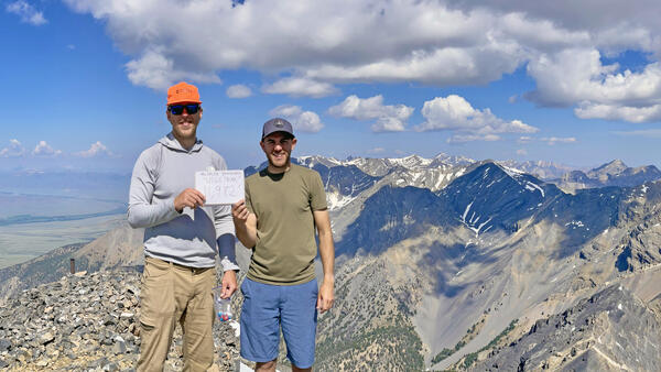
USGS hydro techs Jeff Zingre and Tate Wilson-Johns on the Summit of USGS Peak, Idaho
When you work for the USGS in Idaho, what do you do on the weekend? Climb USGS Peak, of course! Idaho Falls-based USGS hydrologic technicians Jeff Zingre and Tate Wilson-Johns celebrate on the summit of Idaho's 10th highest peak.
When you work for the USGS in Idaho, what do you do on the weekend? Climb USGS Peak, of course! Idaho Falls-based USGS hydrologic technicians Jeff Zingre and Tate Wilson-Johns celebrate on the summit of Idaho's 10th highest peak.