
The Lake Fork Payette River near McCall, Idaho, reached a new peak streamflow on June 3, 2024, overflowing its banks and partially flooding a nearby road. Hydrologic technicians from the USGS Idaho Water Science Center's Boise Field Office responded to collect streamflow measurements. USGS streamgage station 13240000 can be seen at right.
Images
Images intro.
Filter Total Items: 129

Lake Fork Payette River near McCall, Idaho
The Lake Fork Payette River near McCall, Idaho, reached a new peak streamflow on June 3, 2024, overflowing its banks and partially flooding a nearby road. Hydrologic technicians from the USGS Idaho Water Science Center's Boise Field Office responded to collect streamflow measurements. USGS streamgage station 13240000 can be seen at right.

Flood Information Sign, Portneuf River at Pocatello, Idaho
Flood information sign installed near U.S. Geological Survey streamgage station 13075500, Portneuf River at Pocatello, Idaho. The sign was developed by the Idaho Silver Jackets interagency flood risk management team. The USGS Idaho Water Science Center is a charter member of the Idaho Silver Jackets.
Flood information sign installed near U.S. Geological Survey streamgage station 13075500, Portneuf River at Pocatello, Idaho. The sign was developed by the Idaho Silver Jackets interagency flood risk management team. The USGS Idaho Water Science Center is a charter member of the Idaho Silver Jackets.

Mountain Home Plateau, Southern Idaho
Panoramic image of the Mountain Home Plateau, southern Idaho. Hydrologists from the USGS Idaho Water Science Center, in cooperation with the Idaho Department of Water Resources, assessed the water resources of the plateau to help improve resource management.
Panoramic image of the Mountain Home Plateau, southern Idaho. Hydrologists from the USGS Idaho Water Science Center, in cooperation with the Idaho Department of Water Resources, assessed the water resources of the plateau to help improve resource management.

USGS Monitoring of Snake River Quagga Mussel Treatment
USGS scientists collect macroinvertebrate samples from the Snake River in southern Idaho as part of monitoring to determine the effects of quagga mussel eradication efforts on benthic communities.
USGS scientists collect macroinvertebrate samples from the Snake River in southern Idaho as part of monitoring to determine the effects of quagga mussel eradication efforts on benthic communities.

F.H. Newell Building, Boise, Idaho
The F.H. Newell Building in Boise, Idaho, is the headquarters of the USGS Idaho Water Science Center and the Snake River Area Office of the Bureau of Reclamation.
The F.H. Newell Building in Boise, Idaho, is the headquarters of the USGS Idaho Water Science Center and the Snake River Area Office of the Bureau of Reclamation.

Demonstration of multibeam echosounder technology, Knik River near Palmer, Alaska
Mike Knapp, hydraulic engineer with the Alaska Department of Transportation and Public Facilities (far right) introduces USGS hydrologist Taylor Dudunake (back to camera) for a demonstration of multibeam echosounder technology on the Knik River near Palmer, Alaska, July 27, 2023.
Mike Knapp, hydraulic engineer with the Alaska Department of Transportation and Public Facilities (far right) introduces USGS hydrologist Taylor Dudunake (back to camera) for a demonstration of multibeam echosounder technology on the Knik River near Palmer, Alaska, July 27, 2023.

Groundwater Well at Hanscom Air Force Base
A groundwater well in a grassy field near Hanscom Air Force Base in Bedford, Massachusetts.
A groundwater well in a grassy field near Hanscom Air Force Base in Bedford, Massachusetts.
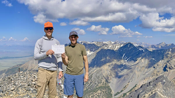
USGS hydro techs Jeff Zingre and Tate Wilson-Johns on the Summit of USGS Peak, Idaho
When you work for the USGS in Idaho, what do you do on the weekend? Climb USGS Peak, of course! Idaho Falls-based USGS hydrologic technicians Jeff Zingre and Tate Wilson-Johns celebrate on the summit of Idaho's 10th highest peak.
When you work for the USGS in Idaho, what do you do on the weekend? Climb USGS Peak, of course! Idaho Falls-based USGS hydrologic technicians Jeff Zingre and Tate Wilson-Johns celebrate on the summit of Idaho's 10th highest peak.

Streamgage 04043050 Trap Rock River near Lake Linden, Michigan
Streamgage 04043050 on the bank of the Trap Rock River near Lake Linden, Michigan in the Keweenaw Peninsula.
Streamgage 04043050 on the bank of the Trap Rock River near Lake Linden, Michigan in the Keweenaw Peninsula.

Gage Greatness Bracket Round 1
At the USGS, we monitor our nation’s water. Our data informs many people, from kayakers to water managers. Gage Greatness allows any Twitter user to vote for their favorite gage (data collection station).
At the USGS, we monitor our nation’s water. Our data informs many people, from kayakers to water managers. Gage Greatness allows any Twitter user to vote for their favorite gage (data collection station).

Southern Idaho Geology Field Trip
Scientists from the U.S. Geological Survey's Idaho Water Science Center, the Idaho Department of Water Resources, and the Idaho Geological Survey conducted a geology field trip of southern Idaho's Mountain Home Plateau in February 2023 to prepare for developing a hydrogeologic framework of the area. This view is from Bonneville Point looking southeast.
Scientists from the U.S. Geological Survey's Idaho Water Science Center, the Idaho Department of Water Resources, and the Idaho Geological Survey conducted a geology field trip of southern Idaho's Mountain Home Plateau in February 2023 to prepare for developing a hydrogeologic framework of the area. This view is from Bonneville Point looking southeast.

Snake River Near Mountain Home, Idaho
Looking southeast to the Snake River across basalt rim of the Snake River Canyon from a point south of Mountain Home, Idaho, and west of Idaho State Highway 51. The Owyhee Mountains can be seen in the background. (Photograph by Lauren M. Zinsser)
Looking southeast to the Snake River across basalt rim of the Snake River Canyon from a point south of Mountain Home, Idaho, and west of Idaho State Highway 51. The Owyhee Mountains can be seen in the background. (Photograph by Lauren M. Zinsser)

Hydrologic technician collects a water sample from Canyon Creek at Wallace, Idaho
USGS Idaho Water Science Center hydrologic technician Niko Parrish collect a water sample at streamgage station 12413125, Canyon Creek above Mouth at Wallace, Idaho, as part of a water-quality monitoring program that the USGS conducts in the Coeur d'Alene River basin in cooperation with the U.S. Environmental Protection Agency.
USGS Idaho Water Science Center hydrologic technician Niko Parrish collect a water sample at streamgage station 12413125, Canyon Creek above Mouth at Wallace, Idaho, as part of a water-quality monitoring program that the USGS conducts in the Coeur d'Alene River basin in cooperation with the U.S. Environmental Protection Agency.

Conducting geophysical logging of a monitoring well in the Raft River basin, Idaho
Scientists from the U.S. Geological Survey's Idaho Water Science Center conducted geophysical logging of aquifer monitoring wells in the Raft River Basin on behalf of the Idaho Department of Water Resources.
Scientists from the U.S. Geological Survey's Idaho Water Science Center conducted geophysical logging of aquifer monitoring wells in the Raft River Basin on behalf of the Idaho Department of Water Resources.

U.S. Geological Survey hydrologic technician Mike Michelotti collects water samples from the South Fork Coeur d'Alene River near Pinehurst, Idaho.
linkU.S. Geological Survey hydrologic technician Mike Michelotti collects water samples from the South Fork Coeur d'Alene River near Pinehurst, Idaho, January 17, 2022. The sample collection is part of ongoing water-quality monitoring in the Coeur d'Alene River basin conducted in cooperation with the U.S. Environmental Protection Agency.

USGS Hydrologist Collects Groundwater Sample at Idaho National Laboratory
In this photo USGS hydrologist Allison Trcka collects a groundwater sample at the Idaho National Laboratory in November 2021. Since 1949, the USGS has partnered with the U.S.
In this photo USGS hydrologist Allison Trcka collects a groundwater sample at the Idaho National Laboratory in November 2021. Since 1949, the USGS has partnered with the U.S.

Buck Creek, Idaho
Buck Creek, Idaho, one year after a wildfire burned the watershed. Buck Creek was one of 36 headwater streams in watersheds burned by wildfire that USGS scientists studied to determine mercury mobilization, methylation, and bioaccumulation in aquatic insects.
Buck Creek, Idaho, one year after a wildfire burned the watershed. Buck Creek was one of 36 headwater streams in watersheds burned by wildfire that USGS scientists studied to determine mercury mobilization, methylation, and bioaccumulation in aquatic insects.

Water sample collected for mercury analysis
An example of a water sample collected to study the link between wildfire and mercury mobilization, methylation, and bioaccumulation in aquatic insects.
An example of a water sample collected to study the link between wildfire and mercury mobilization, methylation, and bioaccumulation in aquatic insects.

Soil sample collected for mercury analysis
An example of a soil sample collected to study the link between wildfire and mercury mobilization, methylation, and bioaccumulation in aquatic insects.
An example of a soil sample collected to study the link between wildfire and mercury mobilization, methylation, and bioaccumulation in aquatic insects.

USGS research hydrologist Austin Baldwin collects a soil sample from a watershed burned by wildfire
linkU.S. Geological Survey research hydrologist Austin Baldwin collects a soil sample near Meadow Creek, Washington, for mercury analysis. Baldwin and USGS colleagues conducted a study of mercury mobilization, methylation, and bioaccumulation in aquatic insects in headwater streams of the Pacific Northwest burned by wildfire.

Mapping river bathymetry in the Copper River Delta, Alaska
USGS scientists Robin Beebee (left) and Jeff Conaway use a boat-mounted multibeam echosounder to map river bathymetry around bridge piers in the Copper River Delta of Alaska. The bathymetric mapping is part of a streambed scour study conducted in cooperation with the Alaska Department of Transportation and Public Facilities.
USGS scientists Robin Beebee (left) and Jeff Conaway use a boat-mounted multibeam echosounder to map river bathymetry around bridge piers in the Copper River Delta of Alaska. The bathymetric mapping is part of a streambed scour study conducted in cooperation with the Alaska Department of Transportation and Public Facilities.