
Installing piezometer on the bank of the New Fork River
Images
Some collected images in Wyoming and Montana.
Filter Total Items: 445

Installing piezometer on the bank of the New Fork River
Installing piezometer on the bank of the New Fork River
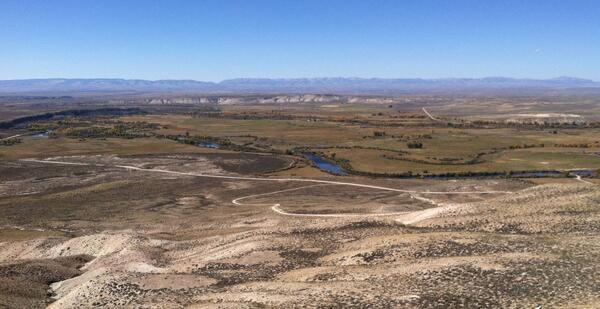
Confluence of New Fork (foreground) and Green Rivers
Confluence of New Fork (foreground) and Green Rivers
Confluence of New Fork (foreground) and Green Rivers

Installing stream thermistor at New Fork Groundwater Streamgage
Installing stream thermistor at New Fork Groundwater Streamgage
Installing stream thermistor at New Fork Groundwater Streamgage

View of 13013650 Streamgage from Snake River Bridge towards the Tetons
View of Streamgage 13013650 Snake River Moose, WY off of Snake River Bridge looking towards the Grand Teton Mountain Range.
View of Streamgage 13013650 Snake River Moose, WY off of Snake River Bridge looking towards the Grand Teton Mountain Range.

Little Powder River above Dry Week, near Weston, Wyoming
Little Powder River above Dry Week, near Weston, Wyoming
Little Powder River above Dry Week, near Weston, Wyoming

Flowing well used for stock water, Green River Basin
Flowing well used for stock water, Green River Basin
Flowing well used for stock water, Green River Basin

Windmill and cattle near Big Piney
Windmill and cattle near Big Piney
Windmill and cattle near Big Piney

Looking upstream from bridge, Tongue river, Monarch
Looking upstream from bridge, Tongue river, Monarch
Looking upstream from bridge, Tongue river, Monarch

Rafters passing USGS Streamgage 13013650 at Moose, WY
Group of rafters passing by USGS Streamgage 13013650 on the Snake River at Moose, WY
Group of rafters passing by USGS Streamgage 13013650 on the Snake River at Moose, WY

Remnants of ice jam on Redwater River at Circle (06177500)
Remnants of ice jam on Redwater River at Circle (06177500)
Remnants of ice jam on Redwater River at Circle (06177500)

Ice jam, Redwater River near Vida (06177825)
Ice jam, Redwater River near Vida (06177825)
Ice jam, Redwater River near Vida (06177825)

Ice jam, Powder River near Arvada (06317000)
Ice jam, Powder River near Arvada (06317000)
Ice jam, Powder River near Arvada (06317000)

East Poplar Study Area map
East Poplar Study Area map

An oil well on the Blackfeet Indian Reservation
An oil well on the Blackfeet Indian Reservation
An oil well on the Blackfeet Indian Reservation

East Poplar oil well
East Poplar oil well

Blackfeet Environmental Office personnel take a groundwater-level meas
Blackfeet Environmental Office personnel take a groundwater-level measurement on the Blackfeet Indian Reservation
Blackfeet Environmental Office personnel take a groundwater-level measurement on the Blackfeet Indian Reservation

Headwaters of Clear Creek, Lower Clark Fork watershed
Headwaters of Clear Creek, Lower Clark Fork watershed
Headwaters of Clear Creek, Lower Clark Fork watershed

Pothole landscape at Medicine Lake NWR.
Pothole landscape at Medicine Lake NWR.
Pothole landscape at Medicine Lake NWR.

Pothole pond landscape with oil well at Medicine Lake NWR
Pothole pond landscape with oil well in background at Medicine Lake NWR.
Pothole pond landscape with oil well in background at Medicine Lake NWR.

Wetland landscape with oil well in background at Medicine Lake NWR.
Wetland landscape with oil well in background at Medicine Lake NWR.
Wetland landscape with oil well in background at Medicine Lake NWR.

Stressed vegetation in oil fields at Medicine Lake NWR
Stressed vegetation in oil fields at Medicine Lake NWR.
Stressed vegetation in oil fields at Medicine Lake NWR.