
This image shows the Landsat flight Operations Team monitoring a pre burn contact, ensuring the satellite is ready for the maneuver.
Images
Peruse our selection of remote sensing and Earth science imagery below.
Filter Total Items: 678

The Landsat Flight Operations Team Monitoring Pre-Burn Contact
This image shows the Landsat flight Operations Team monitoring a pre burn contact, ensuring the satellite is ready for the maneuver.

The Landsat Flight Operations Team Monitoring Landsat 8 Maneuver
This image shows the Landsat Flight Operations Team monitoring the maneuver in real time.
This image shows the Landsat Flight Operations Team monitoring the maneuver in real time.

EROS Radome in the Fall
Fall foliage surrounds the 60-foot radome at the Earth Resources Observation and Science (EROS) Center in Sioux Falls, South Dakota. The radome protects the 10-meter Landsat antenna.
Fall foliage surrounds the 60-foot radome at the Earth Resources Observation and Science (EROS) Center in Sioux Falls, South Dakota. The radome protects the 10-meter Landsat antenna.
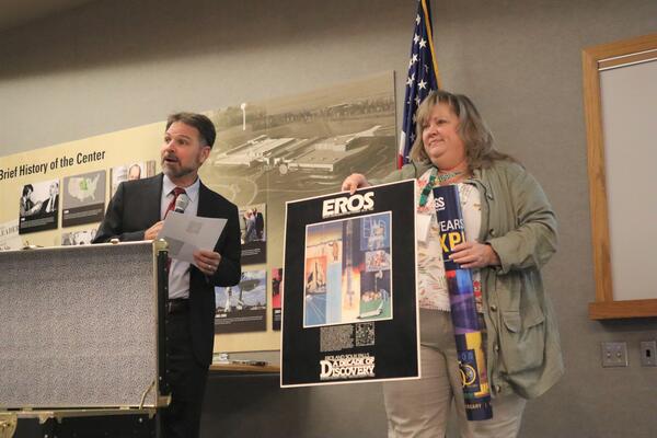
USGS EROS Center Director Pete Doucette and Branch Chief for New Missions Kristi Kline
While USGS Earth Resources Observation and Science (EROS) Center Director Pete Doucette tells the audience a little about the 10th anniversary festivities at EROS during the August 18, 2023, rededication ceremony, EROS Branch Chief for New Missions Kristi Kline holds up a 10th anniversary poster from the time capsule and prepares to add a 50
While USGS Earth Resources Observation and Science (EROS) Center Director Pete Doucette tells the audience a little about the 10th anniversary festivities at EROS during the August 18, 2023, rededication ceremony, EROS Branch Chief for New Missions Kristi Kline holds up a 10th anniversary poster from the time capsule and prepares to add a 50

EROS 50th Anniversary Reception
The USGS Earth Resources Observation and Science (EROS) Center reception area fills with people for a 50th anniversary event August 19, 2023.
The USGS Earth Resources Observation and Science (EROS) Center reception area fills with people for a 50th anniversary event August 19, 2023.

Sioux Falls, South Dakota, Puzzle
Large floor puzzles of Sioux Falls and Denver help entertain guests during the 50th anniversary event August 19, 2023.
Large floor puzzles of Sioux Falls and Denver help entertain guests during the 50th anniversary event August 19, 2023.

Public Tour at USGS EROS
Laura Nemec, a contractor at the USGS Earth Resources Observation and Science (EROS) Center, guides a tour group at the 50th anniversary event August 19, 2023. In the background is a display showing the size of the Landsat 9 satellite.
Laura Nemec, a contractor at the USGS Earth Resources Observation and Science (EROS) Center, guides a tour group at the 50th anniversary event August 19, 2023. In the background is a display showing the size of the Landsat 9 satellite.

EROS 50th Anniversary poster
The commemorative poster for the 50th anniversary celebration, in 2023, of the USGS Earth Resources Observation and Science (EROS) Center in South Dakota.
The commemorative poster for the 50th anniversary celebration, in 2023, of the USGS Earth Resources Observation and Science (EROS) Center in South Dakota.

USGS Director David Applegate and USGS EROS Center Director Pete Doucette plant a tree
On August 19, 2023, USGS Director David Applegate and USGS Earth Resources Observation and Science (EROS) Center Director Pete Doucette use golden shovels that have been used at other EROS dedication events to help dedicate a red oak tree, a long-living species, that will be planted at EROS as a symbolic gesture to its future beyond 50 years.
On August 19, 2023, USGS Director David Applegate and USGS Earth Resources Observation and Science (EROS) Center Director Pete Doucette use golden shovels that have been used at other EROS dedication events to help dedicate a red oak tree, a long-living species, that will be planted at EROS as a symbolic gesture to its future beyond 50 years.

Landsat View of Honolulu Area
This Landsat 8 image, acquired June 11, 2023, gives a view Hawaii's state capital Honolulu and the surrounding area along the eastern shoreline of O'ahu. Center in this image is the Daniel K.
This Landsat 8 image, acquired June 11, 2023, gives a view Hawaii's state capital Honolulu and the surrounding area along the eastern shoreline of O'ahu. Center in this image is the Daniel K.

Satellite ground station in Svalbard, Norway taken during LGSOWG meeting
This photo was taken at the satellite ground receiving station in Svalbard, Norway during Landsat Ground Station Operators Working Group 51st meeting.
Visit this News page for more information about the meeting.
This photo was taken at the satellite ground receiving station in Svalbard, Norway during Landsat Ground Station Operators Working Group 51st meeting.
Visit this News page for more information about the meeting.

EROS By the Numbers (1975)
Infographic highlighting EROS numbers in 1975. Text reads:
By the Numbers: EROS in 1975
Infographic highlighting EROS numbers in 1975. Text reads:
By the Numbers: EROS in 1975

SD Representative Ben Reifel
Ben Reifel, a representative of South Dakota state, worked to get the USGS EROS facility in his state.
Ben Reifel, a representative of South Dakota state, worked to get the USGS EROS facility in his state.

MRLC Logo
The Multi-Resolution Land Characteristics (MRLC) Consortium is a group of federal agencies who coordinate and generate consistent and relevant land cover information at the national scale. Learn more here: https://www.mrlc.gov/.
The Multi-Resolution Land Characteristics (MRLC) Consortium is a group of federal agencies who coordinate and generate consistent and relevant land cover information at the national scale. Learn more here: https://www.mrlc.gov/.

Sagebrush plant in Boise, Idaho
A sagebrush plant photographed at a park in Boise, Idaho. Sagebrush landscapes cover a vast part of the western U.S. but are threatened by invasive grasses and a cycle of more frequent and more intense wildfires.
A sagebrush plant photographed at a park in Boise, Idaho. Sagebrush landscapes cover a vast part of the western U.S. but are threatened by invasive grasses and a cycle of more frequent and more intense wildfires.

Landsat Science Products Analyze Water, Fire, and Snow
The USGS EROS Landsat Satellites Data System's (LSDS) Science Research and Development (LSRD) transforms Landsat data into value-added science, offering Landsat Science Products for advanced analysis of water, fire, and snow.
The USGS EROS Landsat Satellites Data System's (LSDS) Science Research and Development (LSRD) transforms Landsat data into value-added science, offering Landsat Science Products for advanced analysis of water, fire, and snow.

Keeping Satellite Data Accurate and Consistent
The EROS Calibration/Validation (Cal/Val) Center of Excellence (ECCOE) compares Landsat and other remotely sensed data to known reference points on the ground to ensure consistency - a process called calibration and validation.
The EROS Calibration/Validation (Cal/Val) Center of Excellence (ECCOE) compares Landsat and other remotely sensed data to known reference points on the ground to ensure consistency - a process called calibration and validation.

Landsat Next - The Future of the Landsat Program
Landsat Next, planned for launch in late 2030/early 2031, will be a constellation of three identical satellites that together will view the Earth's surface more frequently and provide more detail about its surface.
Landsat Next, planned for launch in late 2030/early 2031, will be a constellation of three identical satellites that together will view the Earth's surface more frequently and provide more detail about its surface.

National Land Cover Database (NLCD) 2021: Conterminous U.S. Land Cover
Map of the Conterminous U.S. showing the Land Cover layer from the NLCD 2021.
Learn more about NLCD at www.usgs.gov/centers/eros/science/national-land-cover-database
Map of the Conterminous U.S. showing the Land Cover layer from the NLCD 2021.
Learn more about NLCD at www.usgs.gov/centers/eros/science/national-land-cover-database

Exterior drone image of the USGS Earth Resources Observation and Science (EROS) Center
Exterior drone image of the USGS Earth Resources Observation and Science (EROS) Center near Sioux Falls, South Dakota.
Exterior drone image of the USGS Earth Resources Observation and Science (EROS) Center near Sioux Falls, South Dakota.

Exterior drone image of USGS Earth Resources Observation and Science (EROS) Center
An exterior drone image of USGS Earth Resources Observation and Science (EROS) Center in summer 2023 near Sioux Falls, South Dakota.
An exterior drone image of USGS Earth Resources Observation and Science (EROS) Center in summer 2023 near Sioux Falls, South Dakota.