U.S. flag

An official website of the United States government

Videos

Videos intro.
Filter Total Items: 46
Trees, rocks and mud on ground near burnt trees Hermits Peak-Calf Canyon debris flow
Hermits Peak-Calf Canyon debris flow

Heavy rainfall on the afternoon of August 3, 2022 triggered a debris flow in the Hermits Peak-Calf Canyon burn area.  A USGS monitoring station installed in the drainage basin captured video footage of the flow.  This clip of the video shows the flow from 13:43:00 MDT to 13:45:32 MDT.

0:00 (13:43 MDT) Start of Video

Backpack next to rock outcrop Utah’s ancient mega-landslides
Utah’s ancient mega-landslides

During the late Oligocene to early Miocene, the Marysvale volcanic field of southwestern Utah experienced three consecutive, catastrophic, mega-scale collapse events: the Sevier, Markagunt, and Black Mountains gravity slides, which we refer to collectively as the Marysvale gravity slide complex (MGSC).

During the late Oligocene to early Miocene, the Marysvale volcanic field of southwestern Utah experienced three consecutive, catastrophic, mega-scale collapse events: the Sevier, Markagunt, and Black Mountains gravity slides, which we refer to collectively as the Marysvale gravity slide complex (MGSC).

rock sample sitting on table Shear surface undulations modulate gouge strength and contribute to divergent landslide acceleration
Shear surface undulations modulate gouge strength and contribute to divergent landslide acceleration

Landslides display a broad spectrum of speeds for incompletely known reasons. Sliding occurs along slickensided undulatory shear surfaces within boundary shear gouge comprising clay mineral and non-clay (granular) particle mixtures, similar to tectonic fault gouge.

Landslides display a broad spectrum of speeds for incompletely known reasons. Sliding occurs along slickensided undulatory shear surfaces within boundary shear gouge comprising clay mineral and non-clay (granular) particle mixtures, similar to tectonic fault gouge.

person standing next pile of large rocks The building and upkeep of a landslide hazards program: The confluence (collision?) of science, history, politics, and public opinion – A Blue Ridge perspective on a national challenge
The building and upkeep of a landslide hazards program: The confluence (collision?) of science, history, politics, and public opinion – A Blue Ridge perspective on a national challenge
Landslide susceptibility map generated using RegionGrow3D

Landslide susceptibility is commonly assessed using physics-based slope stability models. However, modeling the three-dimensional (3D) mechanics of discrete landslides, on a regional scale, remains challenging.

Landslide susceptibility is commonly assessed using physics-based slope stability models. However, modeling the three-dimensional (3D) mechanics of discrete landslides, on a regional scale, remains challenging.

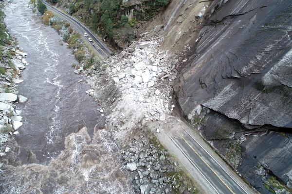
road at base of steep slope next to river, and rocks covering the road at one point Landslide case studies across California’s diverse terrain
Landslide case studies across California’s diverse terrain

California is one of the most geologically diverse states in the nation, the second most seismically active, and first in seismic risk with a population approaching 40 million.

California is one of the most geologically diverse states in the nation, the second most seismically active, and first in seismic risk with a population approaching 40 million.

mountain landscape with snow covered mountains in background Climate change and landslides in subpolar Alaska: Less ice, more water
Climate change and landslides in subpolar Alaska: Less ice, more water

Landslide initiation processes in subarctic Alaska are complicated by the prevalence of ice-rich permafrost. Permafrost and permafrost thaw influence landslide type, frequency, and continued ground surface deformation, resulting in positive feedbacks between permafrost thaw and landsliding.

Landslide initiation processes in subarctic Alaska are complicated by the prevalence of ice-rich permafrost. Permafrost and permafrost thaw influence landslide type, frequency, and continued ground surface deformation, resulting in positive feedbacks between permafrost thaw and landsliding.

mountain Rockfall, Cliff Retreat in Yosemite Valley since Last Glacial Maximum
Rockfall, Cliff Retreat in Yosemite Valley since Last Glacial Maximum

The granitic cliffs of Yosemite Valley produce frequent rockfalls, modifying the landscape but also posing risk to park visitors. Analyses of terrestrial lidar and historical structure-from-motion photogrammetry data provide relatively precise short-term (approximately 40 years) rates of rockfall and cliff retreat.

The granitic cliffs of Yosemite Valley produce frequent rockfalls, modifying the landscape but also posing risk to park visitors. Analyses of terrestrial lidar and historical structure-from-motion photogrammetry data provide relatively precise short-term (approximately 40 years) rates of rockfall and cliff retreat.

highway and access roads in narrow canyon with river at the bottom Evaluating rockfall frequency from natural slopes (multiple methods)
Evaluating rockfall frequency from natural slopes (multiple methods)

Understanding of rockfall frequency-magnitude relationships is important for managing rockfall hazards, but characterizing these relationships is a challenging problem due to limited data, limited access, and the difficulty of accurately dating historic rockfalls.

Understanding of rockfall frequency-magnitude relationships is important for managing rockfall hazards, but characterizing these relationships is a challenging problem due to limited data, limited access, and the difficulty of accurately dating historic rockfalls.

aerial photo of mountainside with road cutting across Infrastructure on ice – when road rides on accelerating rock glacier
Infrastructure on ice – when road rides on accelerating rock glacier

The 92-mile, dead-end Denali Park Road crosses an accelerating rock glacier. Until 2014, the rock glacier would only displace the road a few tens of centimeters per year, however during the summer of 2021 the rock glacier has moved the road almost 40 cm/day.

The 92-mile, dead-end Denali Park Road crosses an accelerating rock glacier. Until 2014, the rock glacier would only displace the road a few tens of centimeters per year, however during the summer of 2021 the rock glacier has moved the road almost 40 cm/day.

Snow avalanches: A hazard and driver of landscape change

Snow avalanches kill, on average, 27 people in the United States each year and impact infrastructure and commerce in mountainous areas.

Snow avalanches kill, on average, 27 people in the United States each year and impact infrastructure and commerce in mountainous areas.

Water, sediment supply reqs—post-wildfire debris flows in western U.S.

We sometimes fall back on an implicit model that post-wildfire debris flows are only triggered once a certain level of saturation or rainfall is reached, and that the sediment supply is soon exhausted and future flows are unlikely until it recharges.

We sometimes fall back on an implicit model that post-wildfire debris flows are only triggered once a certain level of saturation or rainfall is reached, and that the sediment supply is soon exhausted and future flows are unlikely until it recharges.

Active landsliding and rock strength controls along Big Sur Coast, CA

The Santa Lucia Mountains of the Big Sur coast, California contain abundant active landslides.

Widespread landslides during the 2018 wet year in Pittsburgh

The record 2018 wet year in Pittsburgh resulted in widespread landslides throughout the region, many of which caused considerable damage to residential property and transportation infrastructure.

The record 2018 wet year in Pittsburgh resulted in widespread landslides throughout the region, many of which caused considerable damage to residential property and transportation infrastructure.

Pennsylvania Landslides, Pittsburgh and Beyond: A 40-year Perspective

A broad overview of landslide geology across Pennsylvania, and historical and current work on landslides by the Pennsylvania Survey and others. The diverse geology and topography of Pennsylvania's woods provides a variety of landslide problems beyond the well-known issues around Pittsburgh.

A broad overview of landslide geology across Pennsylvania, and historical and current work on landslides by the Pennsylvania Survey and others. The diverse geology and topography of Pennsylvania's woods provides a variety of landslide problems beyond the well-known issues around Pittsburgh.

rocks and trees on hillside during rainstorm Calwood Fire, Heil Ranch post-fire debris-flow monitoring station, July 31, 2021
Calwood Fire, Heil Ranch post-fire debris-flow monitoring station, July 31, 2021

Calwood burn area, Heil Ranch post-fire debris-flow monitoring station video footage from rainstorm on July 31, 2021 from 14:07 MDT to 14:13:11 MDT.

Calwood burn area, Heil Ranch post-fire debris-flow monitoring station video footage from rainstorm on July 31, 2021 from 14:07 MDT to 14:13:11 MDT.

rocks and trees on hillside during rainstorm Calwood Fire, Calwood post-fire debris-flow monitoring station, July 31, 2021
Calwood Fire, Calwood post-fire debris-flow monitoring station, July 31, 2021

Calwood burn area, Calwood post-fire debris-flow monitoring station video footage from rainstorm on July 31, 2021 from 14:06 MDT to 14:13:05 MDT.

Calwood burn area, Calwood post-fire debris-flow monitoring station video footage from rainstorm on July 31, 2021 from 14:06 MDT to 14:13:05 MDT.

Contrib. of Rock-Mass Strength to Topographic Form and Post-Fire Eros.

Rock-mass strength is typically assumed to influence geomorphic processes by setting the erodibility of landscapes. However, the contribution of rock-mass strength to topographic form is often overlooked, largely because rock-mass strength is challenging to quantify over the broad spatial scales relevant to geomorphology.

Rock-mass strength is typically assumed to influence geomorphic processes by setting the erodibility of landscapes. However, the contribution of rock-mass strength to topographic form is often overlooked, largely because rock-mass strength is challenging to quantify over the broad spatial scales relevant to geomorphology.

Washington Geological Survey’s Landslide Hazard Program

In 2015, the Washington Geological Survey received legislative funding to start a Landslide Hazards Program (LHP). The LHP has three primary functions: landslide inventory mapping, post-wildfire debris flow assessments, and emergency response.

In 2015, the Washington Geological Survey received legislative funding to start a Landslide Hazards Program (LHP). The LHP has three primary functions: landslide inventory mapping, post-wildfire debris flow assessments, and emergency response.

HayWired Scenario - Movie

The HayWired earthquake scenario, led by the U.S. Geological Survey (USGS), anticipates the impacts of a hypothetical magnitude-7.0 earthquake on the Hayward Fault.

The HayWired earthquake scenario, led by the U.S. Geological Survey (USGS), anticipates the impacts of a hypothetical magnitude-7.0 earthquake on the Hayward Fault.

Debris flow monitoring at Chalk Cliffs, CO (2017)

The USGS and its cooperators have installed debris-flow monitoring equipment in the largest drainage basin at Chalk Cliffs, CO. Data collection at this site supports research on the hydrologic factors that control debris-flow initiation, entrainment, and flow dynamics.

The USGS and its cooperators have installed debris-flow monitoring equipment in the largest drainage basin at Chalk Cliffs, CO. Data collection at this site supports research on the hydrologic factors that control debris-flow initiation, entrainment, and flow dynamics.