
Electrofishing Niagara River, NY
Images
Images intro.
Filter Total Items: 318

Electrofishing Niagara River, NY
Electrofishing Niagara River, NY

Niagara River Carp
USGS technicians prepare to weigh a common carp during fish processing
USGS technicians prepare to weigh a common carp during fish processing

DEC collaborators collect fish from a Niagara River tributary
DEC collaborators collect fish from a Niagara River tributary using an electrofishing boat
DEC collaborators collect fish from a Niagara River tributary using an electrofishing boat

Eighteen Mile Creek at Burt Dam at Burt, NY
Andrew Kowalczk collecting a water quality sample below dam in Eighteenmile Creek at Burt, NY ( 04219768) as part of the Great Lake Restoration Initiative (GLRI).
Andrew Kowalczk collecting a water quality sample below dam in Eighteenmile Creek at Burt, NY ( 04219768) as part of the Great Lake Restoration Initiative (GLRI).

Field Photo Friday January 2019
A team of biologists, Barry Baldigo, Luis Rodriguez, Mike DeMoulpied, and Abbey Holsopple (from left to right), prepare to conduct a survey for invasive round goby on the New York State Canal system near Rome, NY in 2018. Photo by Scott George
A team of biologists, Barry Baldigo, Luis Rodriguez, Mike DeMoulpied, and Abbey Holsopple (from left to right), prepare to conduct a survey for invasive round goby on the New York State Canal system near Rome, NY in 2018. Photo by Scott George

Zebra Mussels St. Lawrence River
During a National Water Quality Network (NWQN) sampling trip in May to the St Lawrence River, Hydrologic Technician Dave Knauer finds a batch of Zebra mussels attached to the boat anchor.
During a National Water Quality Network (NWQN) sampling trip in May to the St Lawrence River, Hydrologic Technician Dave Knauer finds a batch of Zebra mussels attached to the boat anchor.

Cattaraugus Creek near Springville, NY
ADCP measurement on a snowy day at the Cattaraugus Creek near Springville, NY
ADCP measurement on a snowy day at the Cattaraugus Creek near Springville, NY

Groundwater - Surveying - GNSS Suffolk County, Long Island, NY
Groundwater - Surveying - Global Navigation Satellite System (GNSS) Suffolk County, Long Island, NY
Groundwater - Surveying - Global Navigation Satellite System (GNSS) Suffolk County, Long Island, NY

Bad River Watershed, Wisconsin
Bad River Watershed, Wisconsin

USGS Storm-Tide Sensor
USGS storm-tide sensor bolted to a cement jetty on the Atlantic Ocean coast at Fire Island, New York. USGS scientists deployed over 50 sensors along the coast of Maine, New Hampshire, Massachusetts, Rhode Island, Connecticut, New York, New Jersey and Delaware to study a Nor'easter that affected the Northeast in March of 2018.
USGS storm-tide sensor bolted to a cement jetty on the Atlantic Ocean coast at Fire Island, New York. USGS scientists deployed over 50 sensors along the coast of Maine, New Hampshire, Massachusetts, Rhode Island, Connecticut, New York, New Jersey and Delaware to study a Nor'easter that affected the Northeast in March of 2018.

Esopus River rapids
Esopus River rapids sediment sampling January 2018
Esopus River rapids sediment sampling January 2018

Mohawk River Ice Jam at Lock 8 in Schenectady, NY
Mohawk River Ice Jam at Lock 8 in Schenectady, NY near USGS gaging station 01354330
Mohawk River Ice Jam at Lock 8 in Schenectady, NY near USGS gaging station 01354330
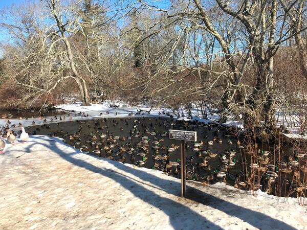
Hook Pond Dreen at Davids Lane, East Hampton, New York
Ducks in Hook Pond Dreen at Davids Lane, East Hampton, New York
Ducks in Hook Pond Dreen at Davids Lane, East Hampton, New York

Field Photo Friday Winner for April 2018
Transporting equipment used for maintenance of groundwater well CT2498 in Perrysburg, New York
Transporting equipment used for maintenance of groundwater well CT2498 in Perrysburg, New York

Moreau Lake, Moreau, New York
Moreau Lake, Moreau, New York

Hydrogeologic Framework Mapping - Long Island
Hydrogeologic Framework Mapping - Long Island
Hydrogeologic Framework Mapping - Long Island

Carman's River
Carman's River, Long Island, New York

Peconic River
Peconic River, Long Island, New York

Stream Discharge Measurement at Peconic River
USGS scientist Amy Simonson making a stream flow measurement in the Peconic River on Long Island, New York
USGS scientist Amy Simonson making a stream flow measurement in the Peconic River on Long Island, New York

Weir at the Peconic River
Weir or low dam at the Peconic River
Weir or low dam at the Peconic River

Saltwater Interface Mapping- Long Island
Saltwater Interface Mapping using electromagnetic sounding - Long Island
Saltwater Interface Mapping using electromagnetic sounding - Long Island