U.S. flag

An official website of the United States government

Images

Images intro.
Filter Total Items: 366
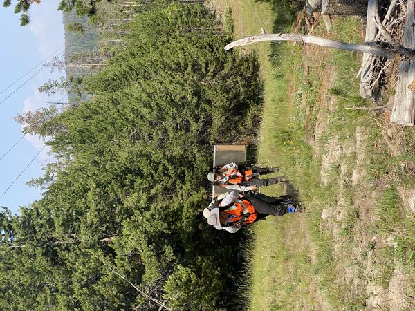
USGS scientists carrying field equipment to set up a gas monitoring station in Yellowstone National Park

USGS scientists Laura Dobeck and Sara Peek carrying field equipment to set up a gas monitoring station in Yellowstone National Park. USGS photo by Jennifer Lewicki, July 13, 2021.

USGS scientists Laura Dobeck and Sara Peek carrying field equipment to set up a gas monitoring station in Yellowstone National Park. USGS photo by Jennifer Lewicki, July 13, 2021.

Field team installs scanning DOAS at Mount St. Helens

USGS Cascades Volcano Observatory Physical Science Technician Brian Meyers installs a data telemetry antenna on a volcano monitoring station at Mount St. Helens. A DOAS scanner is mounted above the flat-panel antenna at the top of the mast.

USGS Cascades Volcano Observatory Physical Science Technician Brian Meyers installs a data telemetry antenna on a volcano monitoring station at Mount St. Helens. A DOAS scanner is mounted above the flat-panel antenna at the top of the mast.

Mount Hood (photo) and fault-plane solution for June 5, 2021 earthquake
Mount Hood and Fault-plane Solution for June 5, 2021 Earthquake

Photo of Mount Hood taken June 7, 2003. The fault-plane solution for the M 3.9 earthquake that occurred on June 5, 2021 is in the lower right corner. 

Photo of Mount Hood taken June 7, 2003. The fault-plane solution for the M 3.9 earthquake that occurred on June 5, 2021 is in the lower right corner. 

Monument Geyser Basin

View of Monument Geyser Basin in Yellowstone National Park, with one of the silica spire "monuments" (from which the basin gets its name) in the foreground. USGS photo by Mike Poland, May 15, 2021.

View of Monument Geyser Basin in Yellowstone National Park, with one of the silica spire "monuments" (from which the basin gets its name) in the foreground. USGS photo by Mike Poland, May 15, 2021.

Roaring Mountain, Yellowstone National Park

Roaring Mountain, an acid-sulfate thermal area about 5 miles south of Norris Geyser Basin along the Norris-Mammoth road.  At times during the late 1800s and early 1900s, the sound of gas escaping from vents could be heard over a mile away, but today the thermal area is mostly quiet, although remains intensely hot with over 100 megawatts of geothermal radiative

Roaring Mountain, an acid-sulfate thermal area about 5 miles south of Norris Geyser Basin along the Norris-Mammoth road.  At times during the late 1800s and early 1900s, the sound of gas escaping from vents could be heard over a mile away, but today the thermal area is mostly quiet, although remains intensely hot with over 100 megawatts of geothermal radiative

The two dominant rock types found on Mount Everts, Yellowstone National Park

Photographs of the two dominant rock types found on Mount Everts: the Everts Formation (photo by Natali Kragh, May 18, 2021) and the Landslide Creek Formation (photo by Emma Kerins, May 2021). Notice the difference in scale between these two units, indicated by the pencil and field book.

Photographs of the two dominant rock types found on Mount Everts: the Everts Formation (photo by Natali Kragh, May 18, 2021) and the Landslide Creek Formation (photo by Emma Kerins, May 2021). Notice the difference in scale between these two units, indicated by the pencil and field book.

Washington State Governor Proclaims May 2021 as Volcano Awareness Month
Washington State Governor Proclaims May 2021 as Volcano Awareness Mont

Washington State Governor Proclaims May 2021 as Volcano Awareness Month.

Thermal anomaly map of Yellowstone National Park based on a Landsat 8 nighttime thermal infrared image from 9 January 2021

Thermal anomaly map of Yellowstone National Park, based on a Landsat 8 nighttime thermal infrared image from 9 January 2021.  The color ramp indicates the intensity of the above-background thermal anomaly for each thermal area.  Lakes are blue.  Yellowstone caldera and resurgent domes are outlined in black.

Thermal anomaly map of Yellowstone National Park, based on a Landsat 8 nighttime thermal infrared image from 9 January 2021.  The color ramp indicates the intensity of the above-background thermal anomaly for each thermal area.  Lakes are blue.  Yellowstone caldera and resurgent domes are outlined in black.

Structural map of the onset of the Yellowstone-Snake River Plain hotspot track

Beginning of Yellowstone-Snake River Plain hotspot track and resulting northeasterly path of the ancestral Missouri River starting about 16.5 million years ago.  Modified from Hyndman D.W., and Thomas, R.C., 2020, Roadside Geology of Montana, Mountain Press Publishing, 464 p.

Beginning of Yellowstone-Snake River Plain hotspot track and resulting northeasterly path of the ancestral Missouri River starting about 16.5 million years ago.  Modified from Hyndman D.W., and Thomas, R.C., 2020, Roadside Geology of Montana, Mountain Press Publishing, 464 p.

Section from the piston core YL92-1C, collected in south-central Yellowstone Lake

Section from the piston core YL92-1C, collected in south-central Yellowstone Lake. The core is viewed horizontally, with the top of core to the left. The core section shown is from 5.21–5.63 meters (17–18.4 feet) depth.

Section from the piston core YL92-1C, collected in south-central Yellowstone Lake. The core is viewed horizontally, with the top of core to the left. The core section shown is from 5.21–5.63 meters (17–18.4 feet) depth.

Satellite view of Ngorongoro volcano, in Tanzania, east Africa

Ngorongoro volcano, in Tanzania, east Africa, is a caldera that formed 2-3 million years ago.  The Ngorongoro Conservation Area is a UNESCO World Heritage Site and home to one of the densest concentrations of wildlife in Africa.  Satellite Image from CNES/Airbus via Google Earth.

Ngorongoro volcano, in Tanzania, east Africa, is a caldera that formed 2-3 million years ago.  The Ngorongoro Conservation Area is a UNESCO World Heritage Site and home to one of the densest concentrations of wildlife in Africa.  Satellite Image from CNES/Airbus via Google Earth.

Absolute versus relative earthquake locations associated with 2019 Ridgecrest, California, foreshock and aftershock sequence

Absolute versus relative earthquake locations associated with 2019 Ridgecrest, California, foreshock and aftershock sequence.  Animated GIF image compares the routine catalog earthquake locations with those from an enhanced catalog employing precise relative locations.  Depths are color-coded as shown.  Triangles indicate seismic stations. 

Absolute versus relative earthquake locations associated with 2019 Ridgecrest, California, foreshock and aftershock sequence.  Animated GIF image compares the routine catalog earthquake locations with those from an enhanced catalog employing precise relative locations.  Depths are color-coded as shown.  Triangles indicate seismic stations. 

Crested pool, in Upper Geyser Basin near Castle Geyser

Crested Pool, in Upper Geyser Basin near Castle Geyser.  Geyser Hill is in the background, and Old Faithful is the steaming feature at the upper right.  USGS photo by Mike Poland, October 12, 2020.

Crested Pool, in Upper Geyser Basin near Castle Geyser.  Geyser Hill is in the background, and Old Faithful is the steaming feature at the upper right.  USGS photo by Mike Poland, October 12, 2020.

The brilliantly blue Sapphire Pool, Yellowstone National Park, steams on a stormy morning
Sapphire Pool, Yellowstone National Park

Sapphire Pool, in Biscuit Basin, steams on a stormy morning. A few “biscuits” remain along the pool’s southern edge (center right of photo) – violent geyser eruptions destroyed hundreds of the features when the pool’s plumbing system changed after being jarred by the 1959 Hebgen Lake earthquake. National Park Service photo by Jacob W. Frank, July 20, 2020.

Sapphire Pool, in Biscuit Basin, steams on a stormy morning. A few “biscuits” remain along the pool’s southern edge (center right of photo) – violent geyser eruptions destroyed hundreds of the features when the pool’s plumbing system changed after being jarred by the 1959 Hebgen Lake earthquake. National Park Service photo by Jacob W. Frank, July 20, 2020.

Photo of volcaniclastic units of the Absaroka volcanic province in northeastern Yellowstone National Park

Photo of geologic units of the Absaroka volcanic province in northeastern Yellowstone National Park that shows volcaniclastic sandstones grading up into a conglomerate, followed by another sequence of sandstone to conglomerate. These repeating layers of the same-looking material make it difficult to assign them to a specific volcanic group.

Photo of geologic units of the Absaroka volcanic province in northeastern Yellowstone National Park that shows volcaniclastic sandstones grading up into a conglomerate, followed by another sequence of sandstone to conglomerate. These repeating layers of the same-looking material make it difficult to assign them to a specific volcanic group.

Petrified trees on Specimen Ridge, Yellowstone National Park

Petrified trees on Specimen Ridge, Yellowstone National Park.  NPS photo by Jake Frank, June 13, 2020.

Two standing petrified (silicified) trees on Specimen Ridge in northeastern Yellowstone National Park
Standing petrified (silicified) trees on Specimen Ridge in northeastern Yellowstone National Park.

Two standing petrified (silicified) trees on Specimen Ridge in northeastern Yellowstone National Park. Photo by Jacob W. Frank, Yellowstone National Park (https://www.flickr.com/photos/yellowstonenps/50016729252).

Annie Carlson, Research Permitting Coordinator for Yellowstone National Park during 2017–2023, during a winter ski expedition in the park

Annie Carlson, Research Permitting Coordinator for Yellowstone National Park during 2017–2023, during a winter ski expedition in the park. National Park Service photo by Jon Nicholson, January 2020.

Image of Yellowstone Lake showing location of core YL16-2C

A digital elevation map of Yellowstone National Park (left) with the location of Yellowstone Lake indicated by the white box. Satellite image (right) of the study site with collection location of core YL16-2C shown by the red circle. Map was originally published in Sabrina Brown’s dissertation (2019).

A digital elevation map of Yellowstone National Park (left) with the location of Yellowstone Lake indicated by the white box. Satellite image (right) of the study site with collection location of core YL16-2C shown by the red circle. Map was originally published in Sabrina Brown’s dissertation (2019).

Sabrina Brown collecting samples from Yellowstone Lake core YL16-2C

Sabrina Brown collecting samples from Yellowstone Lake core YL16-2C at the National Lacustrine Core Facility (LacCore) at the University of Minnesota.

Sabrina Brown collecting samples from Yellowstone Lake core YL16-2C at the National Lacustrine Core Facility (LacCore) at the University of Minnesota.

Several adult wetsalts tiger beetles hunting and basking on and around an alkaline hot spring near Midway Geyser Basin in Yellowstone National Park
Adult tiger beetles near Midway Geyser Basin, Yellowstone National Park

Several adult wetsalts tiger beetles hunting and basking on and around an alkaline hot spring near Midway Geyser Basin in Yellowstone National Park. Photo by Robert K. D. Peterson, 2019.

Several adult wetsalts tiger beetles hunting and basking on and around an alkaline hot spring near Midway Geyser Basin in Yellowstone National Park. Photo by Robert K. D. Peterson, 2019.