
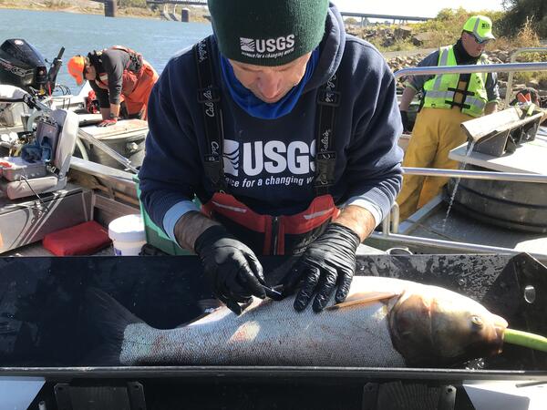
USGS scientist Dalton Lebeda is measuring a Fall Chinook salmon captured in the Snake River. This study is being conducted to determine the percentages of natural and hatchery origin spawners in the upper reach of Hells Canyon.
Images
Search here for some of our available images.
Filter Total Items: 204

Scientist measuring a Fall Chinook salmon captured in the Snake River
USGS scientist Dalton Lebeda is measuring a Fall Chinook salmon captured in the Snake River. This study is being conducted to determine the percentages of natural and hatchery origin spawners in the upper reach of Hells Canyon.

Scenic picture taken with a sUAS (drone) of Hells Canyon, Fall 2023
Scenic picture taken with a sUAS (drone) of Hells Canyon, Fall 2023. In the bottom of the picture, you can see one of our USGS work boats pulled onto shore. USGS scientists are conducting redd surveys for spawning Fall Chinook salmon.
Scenic picture taken with a sUAS (drone) of Hells Canyon, Fall 2023. In the bottom of the picture, you can see one of our USGS work boats pulled onto shore. USGS scientists are conducting redd surveys for spawning Fall Chinook salmon.

Upstream of Lees Ferry, Colorado River, Glen Canyon
Canyon walls and riparian vegetation are reflected in the water of the Colorado River in Glen Canyon, upstream of Lees Ferry. Lees Ferry is downstream of Glen Canyon Dam. Photo by Mariah Giardina, SBSC, USGS.
Canyon walls and riparian vegetation are reflected in the water of the Colorado River in Glen Canyon, upstream of Lees Ferry. Lees Ferry is downstream of Glen Canyon Dam. Photo by Mariah Giardina, SBSC, USGS.

Scientists collect and tag adult green sturgeon on the Sacramento River (Image 1)
USGS scientist helped the U.S. Army Corps of Engineers and FISHBIO to collect and tag adult green sturgeon on the Sacramento River. The purpose of the project is to monitor fish movements and behavior in relation to flood control projects in the Sacramento River.
USGS scientist helped the U.S. Army Corps of Engineers and FISHBIO to collect and tag adult green sturgeon on the Sacramento River. The purpose of the project is to monitor fish movements and behavior in relation to flood control projects in the Sacramento River.

Scientists collect and tag adult green sturgeon on the Sacramento River (Image 2)
USGS scientist helped the U.S. Army Corps of Engineers and FISHBIO to collect and tag adult green sturgeon on the Sacramento River. The purpose of the project is to monitor fish movements and behavior in relation to flood control projects in the Sacramento River.
USGS scientist helped the U.S. Army Corps of Engineers and FISHBIO to collect and tag adult green sturgeon on the Sacramento River. The purpose of the project is to monitor fish movements and behavior in relation to flood control projects in the Sacramento River.
USGS scientist Ryan Tomka shown surgically tagging invasive silver carp in Kentucky
USGS, Western Fisheries Research Center scientist tagging an invasive silver carp with an acoustic transmitter to evaluate the effectiveness of a BioAcoustic Fish Fence (BAFF) to deter upstream migration of invasive carp at Barkley Lock and Dam, Kentucky in October 2022.
USGS, Western Fisheries Research Center scientist tagging an invasive silver carp with an acoustic transmitter to evaluate the effectiveness of a BioAcoustic Fish Fence (BAFF) to deter upstream migration of invasive carp at Barkley Lock and Dam, Kentucky in October 2022.

Sunset behind the Olympic Mountains from a beach on Hood Canal, Washington
The sun setting behind the Olympic Mountains from a beach on Hood Canal, Washington. A beautiful ending of another day.
The sun setting behind the Olympic Mountains from a beach on Hood Canal, Washington. A beautiful ending of another day.

Coho salmon on the Sol Duc River, Washington (Image 1)
Coho salmon migrating on the Sol Duc River, Washington to spawning grounds upstream. Fish must leap through a series of small waterfalls called the Salmon Cascades in Olympic National Park to reach the waters where they were born to complete their life cycle by spawning the next generation.
Coho salmon migrating on the Sol Duc River, Washington to spawning grounds upstream. Fish must leap through a series of small waterfalls called the Salmon Cascades in Olympic National Park to reach the waters where they were born to complete their life cycle by spawning the next generation.

Coho salmon on the Sol Duc River, Washington (Image 2)
Coho salmon migrating on the Sol Duc River, Washington to spawning grounds upstream. Fish must leap through a series of small waterfalls called the Salmon Cascades in Olympic National Park to reach the waters where they were born to complete their life cycle by spawning the next generation.
Coho salmon migrating on the Sol Duc River, Washington to spawning grounds upstream. Fish must leap through a series of small waterfalls called the Salmon Cascades in Olympic National Park to reach the waters where they were born to complete their life cycle by spawning the next generation.

Sampling for European green crab environmental DNA (eDNA) in Pauls Slough in Willapa Bay, Washington
linkSampling for European green crab environmental DNA in Pauls Slough in Willapa Bay, Washington, as part of a study that aims to increase the capacity for early detection monitoring and biosurveillance of invasive green crab.

Sampling for European green crab environmental DNA (eDNA) in Pauls Slough in Willapa Bay, Washington
linkSampling for European green crab environmental DNA (eDNA) in Pauls Slough in Willapa Bay, Washington, as part of a study that aims to increase the capacity for early detection monitoring and biosurveillance of invasive green crab.

Sampling for European green crab environmental DNA (eDNA) in a tide channel at Tokeland in Willapa Bay, Washington
linkSampling for European green crab environmental DNA (eDNA) in a tide channel at Tokeland in Willapa Bay, Washington, as part of a study that aims to increase the capacity for early detection monitoring and biosurveillance of invasive green crab.

Collecting and PIT tagging juvenile steelhead on a tributary of the Wind River
Field work conducted by the Columbia River Research Laboratory on the Wind River. The image shows opening day of collecting and PIT tagging juvenile steelhead on a tributary of the Wind River. Ian Jezorek is conducting the PIT tagging and Brad Liedtke is entering the data.
Field work conducted by the Columbia River Research Laboratory on the Wind River. The image shows opening day of collecting and PIT tagging juvenile steelhead on a tributary of the Wind River. Ian Jezorek is conducting the PIT tagging and Brad Liedtke is entering the data.

Brian Ekstrom and Lance Downing pulling the beach seine to collect juvenile fish at a restoration site on the lower Columbia River
linkBrian Ekstrom and Lance Downing of USGS are pulling a beach seine to collect juvenile fish for monitoring at a restoration site on the lower Columbia River. The restoration site was created with dredge material in October of 2020 and USGS is monitoring juvenile salmon use, community assemblage, and predator presence.

Four nets submerged in a stream to capture drifting invertebrates
Sampling drifting invertebrates from a stream in the North Cascades of Washington State. We perform drift sampling to determine the invertebrate prey quality and quantity available for drift feeding fish. Data gathered from this sampling are used in bioenergetics modeling, a method of estimating fish growth potential.
Sampling drifting invertebrates from a stream in the North Cascades of Washington State. We perform drift sampling to determine the invertebrate prey quality and quantity available for drift feeding fish. Data gathered from this sampling are used in bioenergetics modeling, a method of estimating fish growth potential.

Cape Alava sunset
Picture of Cape Alava at sunset. Cape Alava is a point of land on the outer coast of the Olympic Peninsula. The cape is situated within Olympic National Park, and the Makah Indian Reservation.
Picture of Cape Alava at sunset. Cape Alava is a point of land on the outer coast of the Olympic Peninsula. The cape is situated within Olympic National Park, and the Makah Indian Reservation.

USGS scientist surgically implanting transmitters into juvenile Chinook salmon on the Shasta River, CA
linkUSGS scientists surgically implanting acoustic transmitters into juvenile Chinook salmon on the Shasta River, California. Study fish are tracked in the Shasta and Klamath Rivers as they migrate to the Pacific Ocean. Collected data are used to determine fish survival and migration behaviors.

Photograph of a fish release at the Keller Ferry Marina
Photograph of a fish release at the Keller Ferry Marina, Lake Roosevelt, Lincoln County, Washington.
Photograph of a fish release at the Keller Ferry Marina, Lake Roosevelt, Lincoln County, Washington.

Conducting water quality and light at depth measurements Lake Washington
Photo taken from Magnuson boat launch before conducting water quality and light at depth measurements during Landsat-8 overpass windows on Lake Washington for the U.S. Geological Survey.
To learn more about this project and other related research you can visit the WFRC Ecology Section website.
Photo taken from Magnuson boat launch before conducting water quality and light at depth measurements during Landsat-8 overpass windows on Lake Washington for the U.S. Geological Survey.
To learn more about this project and other related research you can visit the WFRC Ecology Section website.

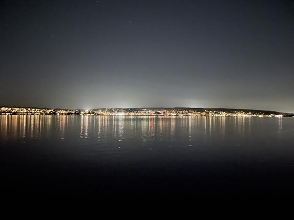
Lighting from the Kirkland waterfront, viewed from the Seattle shoreline
Lighting from the Kirkland waterfront viewed from the Seattle shoreline.
Photo taken from Magnuson boat launch before conducting a synoptic light survey of Lake Washington for the U.S. Geological Survey.
Lighting from the Kirkland waterfront viewed from the Seattle shoreline.
Photo taken from Magnuson boat launch before conducting a synoptic light survey of Lake Washington for the U.S. Geological Survey.
Lighting from the Kirkland waterfront, viewed from Seattle shoreline
Photo taken from Magnuson boat launch before conducting a synoptic light survey of Lake Washington for the U.S. Geological Survey.
Photo taken from Magnuson boat launch before conducting a synoptic light survey of Lake Washington for the U.S. Geological Survey.