The Southwest Biological Science Center:
Providing Unbiased Actionable Science & Information to Support Natural Resource Management Needs of the U.S. & Department of the Interior Priorities
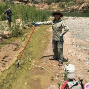
Early detection of aquatic threats
eDNA research in the Colorado River ecosystem & Lake Powell
Supporting energy and mineral development through successful reclamation
Science in Service: How USGS monitoring helps the US Navy sustain a rare species
A new app to report flash floods and debris flows in Grand Canyon
New backcountry alert system for the Grand Canyon
Visitors can subscribe to the alert system using satellite communication devices
The Southwest Fire Innovation Landscape Network
Advanced tools for fuel monitoring and assessment of wildfire risk
Southwest Biological Science Center
The SBSC provides sound science, specialized expertise, and objective and timely tools to Federal and State agencies and the public to inform land management decision-making, and support thriving landscapes for the Southwest’s abundant natural resources and vast public lands. This research assists those who manage, conserve, and rehabilitate rivers and arid regions of the nation.
Dryland Ecology and Management Support - the Terrestrial Drylands Ecology (TDE) branch of SBSC

SBSC conducts research in terrestrial drylands to deliver information that aids land & wildlife management to promote productive ecosystems. Our work provides tools used to mitigate impacts of drought, wildfire, and invasive species, as well as science that supports Department of the Interior economic and cultural activities including recreation and ranching.
Grand Canyon Monitoring and Research Center & Lake Powell research - the River Ecosystems branch of the SBSC

The SBSC Rivers branch, which includes the Grand Canyon Monitoring & Research Center, studies the biology, ecology, and processes of rivers, primarily in the SW. We provide the public and decision makers with relevant scientific information about the status and trends of natural, cultural, and recreational resources of the Colorado River in Grand Canyon, and Lake Powell.
Quick Links
- Learn how SBSC supports DOI priorities
- eDNA research in the Colorado River and Lake Powell
- SBSC initiatives support ecosystems & economies on the Colorado Plateau
- Restoration Assessment & Monitoring Program for the Southwest (RAMPS)
- Outstanding in the Field podcasts
- The Southwest Repeat Photography Collection
- Our Staff Directory
News
Art of Inquiry: Celebrating a semester of Art & Science at the Flagstaff Stemmy Awards
Science in Service: How USGS monitoring helps the US Navy sustain a rare species
New project: Early detection of aquatic threats—eDNA research in the Colorado River ecosystem & Lake Powell
Publications
Summertime methane and carbon dioxide emission rates and associated variables from a national-scale survey of 146 reservoirs in the United States Summertime methane and carbon dioxide emission rates and associated variables from a national-scale survey of 146 reservoirs in the United States
The effects of scientific uncertainty and values trade-offs on flow management decisions for an endangered fish The effects of scientific uncertainty and values trade-offs on flow management decisions for an endangered fish
Groundwater dependency and hydroclimatic influences on riparian and upland vegetation productivity, Upper San Pedro, Arizona, United States Groundwater dependency and hydroclimatic influences on riparian and upland vegetation productivity, Upper San Pedro, Arizona, United States
Science

New Tools for Modern Land Management Decisions

Supporting energy and mineral development through successful reclamation