
Photo taken from Magnuson boat launch before conducting a synoptic light survey of Lake Washington for the U.S. Geological Survey.
Images
Search here for some of our available images.
Filter Total Items: 205
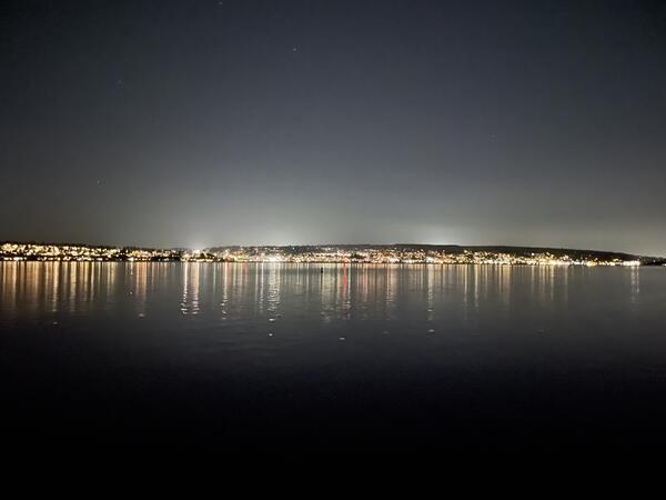
Lighting from the Kirkland waterfront, viewed from Seattle shoreline
Photo taken from Magnuson boat launch before conducting a synoptic light survey of Lake Washington for the U.S. Geological Survey.

Center Director, Western Fisheries Research Center
Western Fisheries Research Center, Center Director, Michael Schmidt, spending time with his dog, Echo, doing their version of outdoor activities “in the backyard” during a peak in COVID cases.
Western Fisheries Research Center, Center Director, Michael Schmidt, spending time with his dog, Echo, doing their version of outdoor activities “in the backyard” during a peak in COVID cases.

Researchers perform gastric lavage on a rainbow trout to sample its stomach contents
Researchers perform gastric lavage on a rainbow trout to sample its stomach contents. This fish was sampled as a part of a food web study on Ross and Diablo Lakes in Washington State to evaluate fish growth and limitations to production.
Researchers perform gastric lavage on a rainbow trout to sample its stomach contents. This fish was sampled as a part of a food web study on Ross and Diablo Lakes in Washington State to evaluate fish growth and limitations to production.

USGS boat tied to dock at Ross Lake, Washington in preparation for food web study
USGS boat tied to dock at Ross Lake during a week-long sampling trip for a food web study. Ross Lake is a large reservoir on the Upper Skagit River in the North Cascade mountains of northern Washington state.
USGS boat tied to dock at Ross Lake during a week-long sampling trip for a food web study. Ross Lake is a large reservoir on the Upper Skagit River in the North Cascade mountains of northern Washington state.

Scientist angling on Ross Lake as part of food web study
Marshal Hoy, a Biological Science Technician, angling on Ross Lake for Western Fisheries Research Center (WFRC) food web study in October 2021. As a part of this study, fish are sampled for stomach contents, scale samples to assess age and growth, and fin tissue for stable isotopes and genetic analysis.
Marshal Hoy, a Biological Science Technician, angling on Ross Lake for Western Fisheries Research Center (WFRC) food web study in October 2021. As a part of this study, fish are sampled for stomach contents, scale samples to assess age and growth, and fin tissue for stable isotopes and genetic analysis.

Scientists staging equipment on dock at Ross Lake, Washington preparing for field work
Researchers stage sampling equipment at the Ross Lake boat ramp and wait for boat to arrive to transport them to camping area. Food web sampling on large lakes requires a substantial amount of sampling gear. Ross Lake is a large reservoir in the North Cascade mountains of northern Washington state.
Researchers stage sampling equipment at the Ross Lake boat ramp and wait for boat to arrive to transport them to camping area. Food web sampling on large lakes requires a substantial amount of sampling gear. Ross Lake is a large reservoir in the North Cascade mountains of northern Washington state.

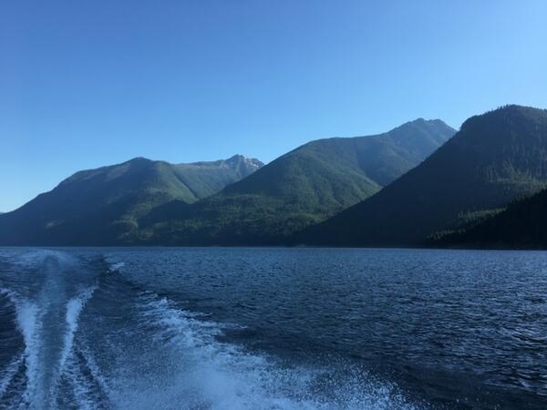
Scenic view of Ross Lake, Washington
Ross Lake is a large reservoir in the North Cascade mountains of northern Washington state. This photo was taken while conducting food web research to support the Skagit River Hydroelectric Dam FERC relicensing process. To learn more about this project and other related research you can visit the WFRC Ecology Section website.
Ross Lake is a large reservoir in the North Cascade mountains of northern Washington state. This photo was taken while conducting food web research to support the Skagit River Hydroelectric Dam FERC relicensing process. To learn more about this project and other related research you can visit the WFRC Ecology Section website.

Scientist working on White Salmon River screw trap
USGS scientist, Jill Hardiman, working on a screw trap on the White Salmon River to assess anadromous fish recolonization following removal of a large dam.
USGS scientist, Jill Hardiman, working on a screw trap on the White Salmon River to assess anadromous fish recolonization following removal of a large dam.

White River spinedace
White River spinedace. Photo taken Wayne E. Kirch Wildlife Management Area, Lund, NV.
White River spinedace. Photo taken Wayne E. Kirch Wildlife Management Area, Lund, NV.

White River spinedace
White River spinedace. Photo taken by Summer Burdick, USGS, Klamath Falls Field Station.
White River spinedace. Photo taken by Summer Burdick, USGS, Klamath Falls Field Station.

White River desert sucker
White River desert sucker. Photo taken Wayne E. Kirch Wildlife Management Area, Lund, NV.
White River desert sucker. Photo taken Wayne E. Kirch Wildlife Management Area, Lund, NV.

USGS passive integrated transponder (PIT) detection antenna
Passive integrated transponder detection antenna located in the Flag Springs Complex in eastern Nevada. This is the only place on earth where White River spinedace still exist.
Passive integrated transponder detection antenna located in the Flag Springs Complex in eastern Nevada. This is the only place on earth where White River spinedace still exist.

White River spinedace
White River spinedace. Photo taken Wayne E. Kirch Wildlife Management Area, Lund, NV.
White River spinedace. Photo taken Wayne E. Kirch Wildlife Management Area, Lund, NV.

Researcher holding a crayfish collected in Diablo Lake
A native crayfish collected in Diablo Lake for an investigation into food availability for native fish and limitations to their growth. Crayfish are invertebrate prey for salmonids and provide useful representative stable isotope values for benthic members of the food web.
A native crayfish collected in Diablo Lake for an investigation into food availability for native fish and limitations to their growth. Crayfish are invertebrate prey for salmonids and provide useful representative stable isotope values for benthic members of the food web.

Photograph of the Sanpoil River in northeast Washington State
Photograph of the Sanpoil River in northeast Washington State. The Sanpoil River is upstream of Grand Coulee and is a tributary of the Columbia River.
Photograph of the Sanpoil River in northeast Washington State. The Sanpoil River is upstream of Grand Coulee and is a tributary of the Columbia River.

Photo of a juvenile native char in a viewing box at Ross Lake, WA
Researchers placed a juvenile native char into a viewing box to help identify the species. This fish was collected as a part of a food web study on Ross and Diablo Lakes in Washington State in order to evaluate fish growth and limitations to production.
Researchers placed a juvenile native char into a viewing box to help identify the species. This fish was collected as a part of a food web study on Ross and Diablo Lakes in Washington State in order to evaluate fish growth and limitations to production.
Scenic view of Ross Lake, Washington with boat wake
Evening shot of Ross Lake with boat wake. Heading back to camp after a day of research. Ross Lake is a large reservoir in the North Cascade mountains of northern Washington state. This photo was taken while conducting food web research to support the Skagit River Hydroelectric Dam FERC relicensing process.
Evening shot of Ross Lake with boat wake. Heading back to camp after a day of research. Ross Lake is a large reservoir in the North Cascade mountains of northern Washington state. This photo was taken while conducting food web research to support the Skagit River Hydroelectric Dam FERC relicensing process.

Elwha River flows through newly vegetated areas of former Lake Mills reservoir 5 years after dam removal.
linkThe Elwha River flows through the footprint of the former reservoir Lake Mills. The wide-angle image also shows revegetated uplands dominated by alder trees meeting coniferous forest along the former shoreline of the reservoir.

Researchers on their way to sampling site Diablo Lake
Researchers on their way to sampling site on Diablo Lake. Diablo Lake is a reservoir in the North Cascade mountains of northern Washington. Created by Diablo Dam, the lake is located between Ross Lake and Gorge Lake on the Skagit River.
Researchers on their way to sampling site on Diablo Lake. Diablo Lake is a reservoir in the North Cascade mountains of northern Washington. Created by Diablo Dam, the lake is located between Ross Lake and Gorge Lake on the Skagit River.

Photograph of the Willamette River, Oregon
USGS researchers from the Western Fisheries Research Center, Columbia River Research Laboratory and the Oregon Water Science Center recently completed a study that reviewed existing fisheries datasets and provided an overview of research approaches for estimating habitat availability and carrying capacity of Pacific salmon in the Willamette River Basin.
USGS researchers from the Western Fisheries Research Center, Columbia River Research Laboratory and the Oregon Water Science Center recently completed a study that reviewed existing fisheries datasets and provided an overview of research approaches for estimating habitat availability and carrying capacity of Pacific salmon in the Willamette River Basin.

Fish biologist catches adult suckers as part of a long-term monitoring
Fish biologist Carolyn Malecha with the Klamath Falls Field Station catches adult suckers as part of a long-term monitoring program that estimates survival and recruitment of suckers.
Fish biologist Carolyn Malecha with the Klamath Falls Field Station catches adult suckers as part of a long-term monitoring program that estimates survival and recruitment of suckers.