
3D Image of a multi-channel seismic (MCS) line showing gas (blue/green) migrating up through fractures in the subsurface, culminating in a 600 meter tall plume of methane gas in the water column that was captured using a Simrad EK60 split beam echo sounder.
Images
Woods Hole Coastal and Marine Science Center images
Filter Total Items: 1090

Water Column and Seismic collage
3D Image of a multi-channel seismic (MCS) line showing gas (blue/green) migrating up through fractures in the subsurface, culminating in a 600 meter tall plume of methane gas in the water column that was captured using a Simrad EK60 split beam echo sounder.

R/V Petrel
R/V Petrel surveying off Beach Haven, NJ during USGS FA 2018-001-FA
R/V Petrel surveying off Beach Haven, NJ during USGS FA 2018-001-FA

RV Petrel towing subbottom profiler
RV Petrel towing subbottom profiler (yellow raft) parallel to the beach to measure the thickness of sand offshore.
RV Petrel towing subbottom profiler (yellow raft) parallel to the beach to measure the thickness of sand offshore.

Ocean Bottom Seismometer Recovery
A WHCMSC and WHOI team recovered six intermediate period ocean bottom seismographs from the continental slope offshore New England in Georges Bank. The instruments had been deployed for about ten months to record background, ambient seismic noise.
A WHCMSC and WHOI team recovered six intermediate period ocean bottom seismographs from the continental slope offshore New England in Georges Bank. The instruments had been deployed for about ten months to record background, ambient seismic noise.

Gas Hydrates and Gas Bubbles
Gas hydrate (orange material) and gas bubbles near the seafloor in the northern Gulf of Mexico. As the methane bubbles are emitted, a rind of gas hydrate immediately forms around some of them. If more bubbles continue to feed from below, gas hydrate forms.
Gas hydrate (orange material) and gas bubbles near the seafloor in the northern Gulf of Mexico. As the methane bubbles are emitted, a rind of gas hydrate immediately forms around some of them. If more bubbles continue to feed from below, gas hydrate forms.

Coastal wetland ecosystems in Jamaica Bay, New York,
Coastal wetland ecosystems in Jamaica Bay, New York, provide important ecosystem services along the highly urbanized Atlantic coast.
Coastal wetland ecosystems in Jamaica Bay, New York, provide important ecosystem services along the highly urbanized Atlantic coast.

Sea level rise scenario model for Dauphin Island, Alabama
This model shows what Dauphin Island, Alabama, may look like under moderate storms but with increasing rates of sea level rise (Passeri and others, 2018).
This model shows what Dauphin Island, Alabama, may look like under moderate storms but with increasing rates of sea level rise (Passeri and others, 2018).
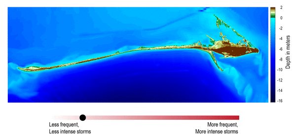
Storm and sea level rise scenario model for Dauphin Island, Alabama
Storm and sea level rise scenario models, like the one shown here, can be used to explore the future. This model shows what Dauphin Island may look like 10 years from now if storms become stronger and more frequent (Passeri and others, 2018).
Storm and sea level rise scenario models, like the one shown here, can be used to explore the future. This model shows what Dauphin Island may look like 10 years from now if storms become stronger and more frequent (Passeri and others, 2018).

USGS aerial imaging mapping team
USGS unmanned aerial system (uas) mapping team on the beach in Dauphin Island, Alabama
USGS unmanned aerial system (uas) mapping team on the beach in Dauphin Island, Alabama

Tulum, Mexico jungle panorama
Tulum, Mexico jungle panorama

Ready to dive in Yucatan Peninsula
USGS personnel preparing to dive in Yucatan Peninsula.
USGS personnel preparing to dive in Yucatan Peninsula.

Tulum, Mexico hike through the jungle
Hike through the jungle in Tulum, Mexico
Hike through the jungle in Tulum, Mexico

Collecting water samples in Yucatan Peninsula, Mexico
Collecting water samples in Yucatan Peninsula, Mexico.
Collecting water samples in Yucatan Peninsula, Mexico.

Herring River, Wellfleet, MA
The Herring River in Wellfleet, MA is a tidally-restricted estuary system. Management options including potential restoration of unrestricted tidal flows require an understanding of pre-restoration sediment conditions
The Herring River in Wellfleet, MA is a tidally-restricted estuary system. Management options including potential restoration of unrestricted tidal flows require an understanding of pre-restoration sediment conditions
Herring River, Wellfleet, MA
The Herring River in Wellfleet, MA is a tidally-restricted estuary system. Management options including potential restoration of unrestricted tidal flows require an understanding of pre-restoration sediment conditions.
The Herring River in Wellfleet, MA is a tidally-restricted estuary system. Management options including potential restoration of unrestricted tidal flows require an understanding of pre-restoration sediment conditions.

Ion Chromatograph
Major ions such as Sulfate and Chloride are measured with an Ion Chromatograph
Major ions such as Sulfate and Chloride are measured with an Ion Chromatograph

Salt Marsh Well Sensor
A well sensor continuously monitors salinity, temperature, and water level in a salt marsh, Cape Cod, MA
A well sensor continuously monitors salinity, temperature, and water level in a salt marsh, Cape Cod, MA

Instrument check at a tidal creek, Falmouth, MA
Meagan Gonneea checks on instruments at a tidal creek in Great Pond, Falmouth, MA. Daily tides drive exchange between coastal wetlands and adjacent estuaries. Here we have instrumented a tidal channel to measure those fluxes over a tidal cycle. When the marsh floods, material is imported from the estuary.
Meagan Gonneea checks on instruments at a tidal creek in Great Pond, Falmouth, MA. Daily tides drive exchange between coastal wetlands and adjacent estuaries. Here we have instrumented a tidal channel to measure those fluxes over a tidal cycle. When the marsh floods, material is imported from the estuary.

Gamma well detectors
Gamma well detectors are used to determine the ages of sediments based on activities of natural and anthropogenic radionuclides
Gamma well detectors are used to determine the ages of sediments based on activities of natural and anthropogenic radionuclides

Coulmeter
Dissolved inorganic carbon (DIC) in water samples is measured with a UIC, Inc. Coulometer
Dissolved inorganic carbon (DIC) in water samples is measured with a UIC, Inc. Coulometer

Cape Cod hazards
USGS geologists Dave Foster and Wayne Baldwin and Andrew Green (University of
KwaZulu-Natal) observe coastal hazards on the Lower Cape, Massachusetts.
USGS geologists Dave Foster and Wayne Baldwin and Andrew Green (University of
KwaZulu-Natal) observe coastal hazards on the Lower Cape, Massachusetts.