
During the 1926 Mauna Loa eruption, an ‘a‘ā flow about 457 m (1500 ft) wide and 9 m (30 ft) high headed straight for the village of Ho‘ōpūloa on April 18, as shown here. By the next day, the lava flow had destroyed a dozen houses, a church, and the wharf, and had nearly obliterated the bay. Photo by Army Air Corps, 11th Photo Section.
Images
Images intro.
Filter Total Items: 7147

HVO looks to the past to better understand future Mauna Loa eruptions
During the 1926 Mauna Loa eruption, an ‘a‘ā flow about 457 m (1500 ft) wide and 9 m (30 ft) high headed straight for the village of Ho‘ōpūloa on April 18, as shown here. By the next day, the lava flow had destroyed a dozen houses, a church, and the wharf, and had nearly obliterated the bay. Photo by Army Air Corps, 11th Photo Section.

On a hillside in Las Marias, USGS scientists examine landslide effects
USGS ground failure experts examine landslides after Hurricane Maria in the municipality of Las Marias, Puerto Rico.
USGS ground failure experts examine landslides after Hurricane Maria in the municipality of Las Marias, Puerto Rico.

A helicopter flight reveals landslides' damage in Utuado municipality
An aerial view of landslide damage after Hurricane Maria in Utuado municipality, Puerto Rico.
An aerial view of landslide damage after Hurricane Maria in Utuado municipality, Puerto Rico.

Overview of Taan Fiord
Overview of Taan Fiord. Inset showing location of Taan Fiord, Alaska in Wrangell St. Elias National Park and Preserve. Taan Fiord is about 100 km from the nearest town, Yakutat, AK. Landsat 8 image of Taan Fiord acquired in 2016. Vegetation loss is clear near the water line.
Overview of Taan Fiord. Inset showing location of Taan Fiord, Alaska in Wrangell St. Elias National Park and Preserve. Taan Fiord is about 100 km from the nearest town, Yakutat, AK. Landsat 8 image of Taan Fiord acquired in 2016. Vegetation loss is clear near the water line.

The water pond from the webcam site. This view provides a better view of the gr
The water pond from the webcam site. This view provides a better view of the greenish zone in the west end of the pond (bottom right of photo).
The water pond from the webcam site. This view provides a better view of the greenish zone in the west end of the pond (bottom right of photo).

A closeup of the northern shoreline shows how opaque the water is against the ro
A closeup of the northern shoreline shows how opaque the water is against the rocks. USGS photo by M. Patrick.
A closeup of the northern shoreline shows how opaque the water is against the rocks. USGS photo by M. Patrick.

Debris flow after the 2003 Old Gran Prix fire
Damage from a major post-wildfire landslide that occurred on 25 December 2003 near Devore, San Bernardino County as a result of the Old/Grand Prix fires that ran through the San Bernardino Mountains.
Damage from a major post-wildfire landslide that occurred on 25 December 2003 near Devore, San Bernardino County as a result of the Old/Grand Prix fires that ran through the San Bernardino Mountains.

Home damaged by post-wildfire debris flow in Montecito, CA.
Damage from a major post-wildfire landslide that occurred on 9 January 2018 near Montecito, Santa Barbara County as a result of the 2017 Thomas Fire.
Damage from a major post-wildfire landslide that occurred on 9 January 2018 near Montecito, Santa Barbara County as a result of the 2017 Thomas Fire.

Scientist launches instrument used to map seafloor off Puerto Rico
USGS marine technician Wayne Baldwin prepares to deploy the hydrophone array during a seismic research cruise off the southwest coast of Puerto Rico on board the R/V Sultana in March 2020.
USGS marine technician Wayne Baldwin prepares to deploy the hydrophone array during a seismic research cruise off the southwest coast of Puerto Rico on board the R/V Sultana in March 2020.

USGS marine technicians launch a hydrophone off Puerto Rico seafloor
USGS marine technicians Alex Nichols (L) and Eric Moore (R) deploy the hydrophone array on a seismic research cruise off the southwest coast of Puerto Rico aboard the R/V Sultana in March 2020.
USGS marine technicians Alex Nichols (L) and Eric Moore (R) deploy the hydrophone array on a seismic research cruise off the southwest coast of Puerto Rico aboard the R/V Sultana in March 2020.

Three scientists launch a "sparker" used in seafloor mapping
USGS research geologist Jason Chaytor (L) and marine technicians Alex Nichols (center) and Eric Moore (R) deploy the “sparker” sound source on a seismic research cruise off the southwest coast of Puerto Rico aboard the R/V Sultana in March 2020.
USGS research geologist Jason Chaytor (L) and marine technicians Alex Nichols (center) and Eric Moore (R) deploy the “sparker” sound source on a seismic research cruise off the southwest coast of Puerto Rico aboard the R/V Sultana in March 2020.

Deploying streamer
Alex Nichols, Wayne Baldwin, and Eric Moore deploying a streamer in Puerto Rico.
Alex Nichols, Wayne Baldwin, and Eric Moore deploying a streamer in Puerto Rico.

Woods Hole Sediment Analysis Lab
View inside the Woods Hole Coastal and Marine Science Center Sediment Analysis Laboratory showing the Beckman Coulter Multisizer 3 and Horiba LA-960 laser diffraction unit.
View inside the Woods Hole Coastal and Marine Science Center Sediment Analysis Laboratory showing the Beckman Coulter Multisizer 3 and Horiba LA-960 laser diffraction unit.

Woods Hole Coastal and Marine Science Center Sediment Analysis Lab
View inside the Woods Hole Coastal and Marine Science Center Sediment Analysis Laboratory showing the laboratory computer workstation, precision balances, and interior of the oven and sieving room.
View inside the Woods Hole Coastal and Marine Science Center Sediment Analysis Laboratory showing the laboratory computer workstation, precision balances, and interior of the oven and sieving room.

Mushroom Pool, in the Lower Geyser Basin of Yellowstone National Park. The pool
Mushroom Pool, in the Lower Geyser Basin of Yellowstone National Park, as it looked in June 23, 1967. The sample that would be the source of Thermus aquaticus strain YT-1 came from this hot spring. Pictured is Thomas Brock standing near the edge of the pool. Image from the self-published "A Scientist in Yellowstone National Park" (Brock, 2017).
Mushroom Pool, in the Lower Geyser Basin of Yellowstone National Park, as it looked in June 23, 1967. The sample that would be the source of Thermus aquaticus strain YT-1 came from this hot spring. Pictured is Thomas Brock standing near the edge of the pool. Image from the self-published "A Scientist in Yellowstone National Park" (Brock, 2017).

Timelapse of water rising in Halema‘uma‘u
This timelapse sequence shows the water pond in Halema‘uma‘u Crater, at Kīlauea's summit, between November 1, 2019, and March 26, 2020. Over this time the water level rose approximately 14 meters (46 feet), equivalent to 67 cm (about 2 feet) per week. The timelapse shows one image per day (with a few cloudy images removed), and is looped several times.
This timelapse sequence shows the water pond in Halema‘uma‘u Crater, at Kīlauea's summit, between November 1, 2019, and March 26, 2020. Over this time the water level rose approximately 14 meters (46 feet), equivalent to 67 cm (about 2 feet) per week. The timelapse shows one image per day (with a few cloudy images removed), and is looped several times.

Davina Passeri presents poster about coastal change research
Davina Passeri of the St. Petersburg Coastal and Marine Science Center presents a poster about coastal change research in Dauphin Island, Alabama at the USGS Southeast Regional Meeting in February 2020.
Davina Passeri of the St. Petersburg Coastal and Marine Science Center presents a poster about coastal change research in Dauphin Island, Alabama at the USGS Southeast Regional Meeting in February 2020.

Ilsa Kuffner presents a poster on coral research
Ilsa Kuffner speaks to a group at the USGS Southeast Regional Meeting in February 2020 about coral research conducted by the St. Petersburg Coastal and Marine Science Center
Ilsa Kuffner speaks to a group at the USGS Southeast Regional Meeting in February 2020 about coral research conducted by the St. Petersburg Coastal and Marine Science Center

Kathryn Smith at an Outreach Event
The USGS St. Petersburg Coastal and Marine Science Center conducted outreach at the Localtopia Event held in February 2020. Staff demonstrated a simulation of how storms can impact sandy coastlines through processes such as erosion.
The USGS St. Petersburg Coastal and Marine Science Center conducted outreach at the Localtopia Event held in February 2020. Staff demonstrated a simulation of how storms can impact sandy coastlines through processes such as erosion.

Water, ash, and the great unknown of explosive volcanic eruptions
Scanning electron microprobe images show the complexity of tiny Icelandic ash grains (150 micron, or 0.006 inch). Image (a) shows a dense and blocky grain, and (b) shows a foamy grain. Photos by J. Schmith.
Scanning electron microprobe images show the complexity of tiny Icelandic ash grains (150 micron, or 0.006 inch). Image (a) shows a dense and blocky grain, and (b) shows a foamy grain. Photos by J. Schmith.
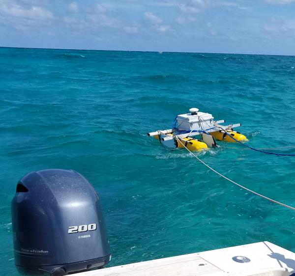
SQUID-5 - Structure-from-Motion Quantitative Underwater Imaging Device
The SQUID-5, or a Structure-from-Motion (SfM) Quantitative Underwater Imaging Device with 5 cameras is a towed surface vehicle with an onboard Global Navigation Satellite System (GNSS) and 5 downward-looking cameras with overlapping views of the seafloor.
The SQUID-5, or a Structure-from-Motion (SfM) Quantitative Underwater Imaging Device with 5 cameras is a towed surface vehicle with an onboard Global Navigation Satellite System (GNSS) and 5 downward-looking cameras with overlapping views of the seafloor.