
Taken while on the 2007 SW review of the Montana Science Center.
Images
Explore water-related photography, imagery, and illustrations.
Filter Total Items: 2402

USGS Gage and Sun River at Simms, MT
Taken while on the 2007 SW review of the Montana Science Center.

Map it Out
USGS, DNR, Fish and wildlife service plan a study on the Spring River. A Tri state study
USGS, DNR, Fish and wildlife service plan a study on the Spring River. A Tri state study

Skagit River, near Concrete WA
Skagit River, near Concrete, WA

Eroding Shoreline Along Alaska's Coast
This photograph shows ice-wedge polygons and an eroding shoreline at Cape Halkett on the Beaufort Sea coast of Alaska. Coastal erosion along the Arctic coast is chronic, widespread and potentially accelerating, posing threats to infrastructure important for defense and energy purposes, natural shoreline habitats and nearby Native communities.
This photograph shows ice-wedge polygons and an eroding shoreline at Cape Halkett on the Beaufort Sea coast of Alaska. Coastal erosion along the Arctic coast is chronic, widespread and potentially accelerating, posing threats to infrastructure important for defense and energy purposes, natural shoreline habitats and nearby Native communities.

Stream flowing in Highland County Virginia, June 26, 2006
Stream flowing in Highland County Virginia, June 26, 2006. Photograph by Samuel H Austin.
Stream flowing in Highland County Virginia, June 26, 2006. Photograph by Samuel H Austin.

Green River at Mammoth Cave National Park, KY
View of the Green River along a trail in Mammoth Cave National Park. USGS operates gages on the river above and below the Park Boundaries.
View of the Green River along a trail in Mammoth Cave National Park. USGS operates gages on the river above and below the Park Boundaries.

Green River Reflections, Mammoth Cave National Park, KY
View of the Green River along a trail in Mammoth Cave National Park. USGS operates gages on the river above and below the Park Boundaries.
View of the Green River along a trail in Mammoth Cave National Park. USGS operates gages on the river above and below the Park Boundaries.

Tropical Beach with Coconut Palm and Seagrapes
Coconut palm, sea grapes, and a white sand beach overlooking Drake's Passage from the island of Tortola in the British Virgin Islands.
Coconut palm, sea grapes, and a white sand beach overlooking Drake's Passage from the island of Tortola in the British Virgin Islands.

A flooded road in Highland County, Virginia.
Streamwater flowing over a rural road in Highland County, Virginia, June, 2006.
Streamwater flowing over a rural road in Highland County, Virginia, June, 2006.

A day in the field
Resource professionals stand in the rain beside a mountain stream.
Resource professionals stand in the rain beside a mountain stream.

Ground-penetrating Radar Survey (GPR)
USGS hydrologist conducts a ground-penetrating radar survey to investigate and characterize the shallow subsurface. The survey was conducted as part of an applied research effort by the USGS Office of Groundwater Branch of Geophysics in 2006.
USGS hydrologist conducts a ground-penetrating radar survey to investigate and characterize the shallow subsurface. The survey was conducted as part of an applied research effort by the USGS Office of Groundwater Branch of Geophysics in 2006.

Near-Surface Geophysics: Two-Dimensional Resistivity
USGS hydrologist conducts a two-dimensional (2D) resistivity survey to investigate and characterize the shallow subsurface. The survey was conducted as part of an applied research effort by the USGS Office of Groundwater Branch of Geophysics in 2006.
USGS hydrologist conducts a two-dimensional (2D) resistivity survey to investigate and characterize the shallow subsurface. The survey was conducted as part of an applied research effort by the USGS Office of Groundwater Branch of Geophysics in 2006.

Sediment core from lake for PAH analysis
Sediment cores from lakes and reservoirs can be used to reconstruct contaminant histories in watersheds. Sediment-core analyses indicate that concentrations of PAHs in many U.S. urban lakes are increasing, and multiple lines of evidence indicate that the source of the PAHs in coal-tar-based pavement sealants.
Sediment cores from lakes and reservoirs can be used to reconstruct contaminant histories in watersheds. Sediment-core analyses indicate that concentrations of PAHs in many U.S. urban lakes are increasing, and multiple lines of evidence indicate that the source of the PAHs in coal-tar-based pavement sealants.

Pouring dust from sealcoated pavement into sample jar
Dust was collected from sealcoated pavements across the U.S. Concentrations of polycyclic aromatic hydrocarbons (PAHs) in dust from sealed pavement in the East, where coal-tar-based products are used, was about 1,000 times higher than in dust from sealed pavement in the West, where asphalt-based products are used.
Dust was collected from sealcoated pavements across the U.S. Concentrations of polycyclic aromatic hydrocarbons (PAHs) in dust from sealed pavement in the East, where coal-tar-based products are used, was about 1,000 times higher than in dust from sealed pavement in the West, where asphalt-based products are used.
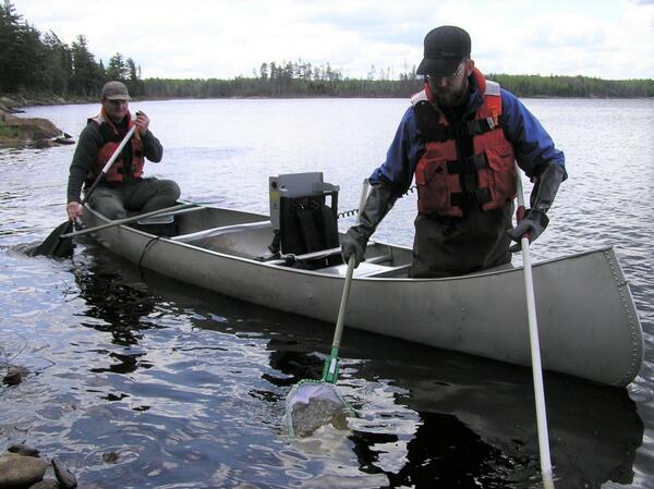
Scientists sampling fish from a canoe on Shoepack Lake
Mark Sandheinrich and Sean Bailey of the University of Wisconsin - La Crosse sampling fish from a canoe on Shoepack Lake in Voyageurs National Park.
Mark Sandheinrich and Sean Bailey of the University of Wisconsin - La Crosse sampling fish from a canoe on Shoepack Lake in Voyageurs National Park.
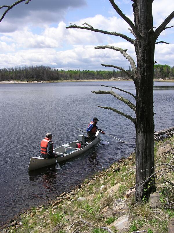
Scientists sampling for fish on Shoepack Lake via canoe
Mark Sandheinrich and Sean Bailey of the University of Wisconsin - La Crosse sampling fish from a canoe on Shoepack Lake in Voyageurs National Park. A burned tree is in the foreground from a previous wildland fire.
Mark Sandheinrich and Sean Bailey of the University of Wisconsin - La Crosse sampling fish from a canoe on Shoepack Lake in Voyageurs National Park. A burned tree is in the foreground from a previous wildland fire.

Electromagnetic Survey
USGS hydrologist conducts a broadband electromagnetic survey in New Orleans, Louisiana. The survey was one of several geophysical methods used during USGS applied research on the utility of the multi-channel analysis of surface waves (MASW) seismic method for non-invasive assessment of earthen levees.
USGS hydrologist conducts a broadband electromagnetic survey in New Orleans, Louisiana. The survey was one of several geophysical methods used during USGS applied research on the utility of the multi-channel analysis of surface waves (MASW) seismic method for non-invasive assessment of earthen levees.

Seismic Survey
USGS hydrologists conduct a seismic survey in New Orleans, Louisiana. The survey was one of several geophysical methods used during USGS applied research on the utility of the multi-channel analysis of surface waves (MASW) seismic method (no pictured here) for non-invasive assessment of earthen levees.
USGS hydrologists conduct a seismic survey in New Orleans, Louisiana. The survey was one of several geophysical methods used during USGS applied research on the utility of the multi-channel analysis of surface waves (MASW) seismic method (no pictured here) for non-invasive assessment of earthen levees.

Flooding of Whitey's Restaurant
USGS personnel measuring flood overflow near Whitey's Restaurant in East Grand Forks.
USGS personnel measuring flood overflow near Whitey's Restaurant in East Grand Forks.

Wyoming-Montana Water Science Center Comparison Discharge Measurement
Wyoming-Montana Water Science Center comparison discharge measurement
Wyoming-Montana Water Science Center comparison discharge measurement

Flint River at Base Flow Conditions
The Flint River below Bainbridge, Georgia, showing base flow conditions. Even at low flows, rivers in this part of Georgia contain enough sediment to color the water brown.
The Flint River below Bainbridge, Georgia, showing base flow conditions. Even at low flows, rivers in this part of Georgia contain enough sediment to color the water brown.