
This 2014 photo shows the new location of the USGS streamgage that measures high flows on the Trinity River in Dallas. The gage was once located on a pier, but in 1975 was moved next to the stream.
Images
Explore water-related photography, imagery, and illustrations.
Filter Total Items: 2402

USGS Streamgage in Dallas, Texas
This 2014 photo shows the new location of the USGS streamgage that measures high flows on the Trinity River in Dallas. The gage was once located on a pier, but in 1975 was moved next to the stream.

Construction of a USGS streamgage in 1939
Construction in 1939 of a streamgage structure at Elm Fork Trinity River near Carrollton, Texas.
Construction in 1939 of a streamgage structure at Elm Fork Trinity River near Carrollton, Texas.

1955 USGS streamgage near Carrollton, Texas
Nearly completed construction of a streamgage structure in 1955 at Elm Fork Trinity River near Carollton, Texas.
Nearly completed construction of a streamgage structure in 1955 at Elm Fork Trinity River near Carollton, Texas.

Early USGS streamgage in Texas
Looking upstream from gage site at Trinity River at Commerce Street Bridge.
Looking upstream from gage site at Trinity River at Commerce Street Bridge.

Early USGS streamgage in Dallas, Texas
This 1922 photo shows an early USGS streamgage on the Trinity River in Dallas.
This 1922 photo shows an early USGS streamgage on the Trinity River in Dallas.

USGS streamgage in 1940 near Derby, Texas
In the earlier years of streamgaging, large “stilling wells” were constructed to contain the equipment needed to collect streamflow data. Historically, most of the streamflow equipment may have been located in these large structures, which were placed in the middle or next to the stream.
In the earlier years of streamgaging, large “stilling wells” were constructed to contain the equipment needed to collect streamflow data. Historically, most of the streamflow equipment may have been located in these large structures, which were placed in the middle or next to the stream.

Oldest version of a USGS streamgage in Texas
One of the oldest versions of a streamgage structure constructed in Texas.
One of the oldest versions of a streamgage structure constructed in Texas.

Oldest version of a USGS streamgage in Texas
A close-up view of the top part of one of the oldest streamgage structures constructed in Texas.
A close-up view of the top part of one of the oldest streamgage structures constructed in Texas.

Discharge Measurement at Moyer Creek
USGS Hydrologist Travis Smith makes a wading (section-by-section) discharge measurement at Moyer Creek stream gauging station near Frankfort, NY to allow for better estimates of streamflow during ice-affected periods in winter.
USGS Hydrologist Travis Smith makes a wading (section-by-section) discharge measurement at Moyer Creek stream gauging station near Frankfort, NY to allow for better estimates of streamflow during ice-affected periods in winter.

Walker Lake
Walker Lake in Nevada on a Spring day
Walker Lake in Nevada on a Spring day
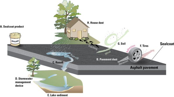
Transport pathways for PAHs from coal-tar-based sealcoat
Coal-tar-based sealcoat is a potent source of PAHs and related chemicals. Worn particles of coal-tar-based sealcoat are transported by rain, wind, tires, and even our feet from pavement to other environmental settings. Sealcoat product (A), after it dries, gradually abrades to a powder and becomes part of the dust on the pavement (B).
Coal-tar-based sealcoat is a potent source of PAHs and related chemicals. Worn particles of coal-tar-based sealcoat are transported by rain, wind, tires, and even our feet from pavement to other environmental settings. Sealcoat product (A), after it dries, gradually abrades to a powder and becomes part of the dust on the pavement (B).
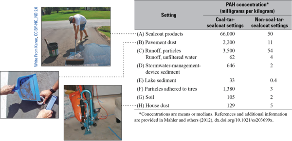
PAHs near pavement sealed or not sealed with coal-tar sealant
Concentrations of polycyclic aromatic hydrocarbons (PAHs) in settings near pavement sealed with coal-tar-based sealants were substantially higher than concentrations in settings where coal-tar sealant was not used.
Concentrations of polycyclic aromatic hydrocarbons (PAHs) in settings near pavement sealed with coal-tar-based sealants were substantially higher than concentrations in settings where coal-tar sealant was not used.

Flow diagram of coal to coal-tar-pitch process
Coal tar is a byproduct of the coking, liquefaction, or gasification of coal. Coal-tar pitch is the residue that remains after the distillation of coal tar. Coal tar and coal-tar pitch are used in coal-tar-based sealcoat products, although use of coal-tar pitch is more common than use of coal tar. Both coal tar and coal-tar pitch are known human carcinogens.
Coal tar is a byproduct of the coking, liquefaction, or gasification of coal. Coal-tar pitch is the residue that remains after the distillation of coal tar. Coal tar and coal-tar pitch are used in coal-tar-based sealcoat products, although use of coal-tar pitch is more common than use of coal tar. Both coal tar and coal-tar pitch are known human carcinogens.

Paddle Boarding on the Guadalupe River
Cool, clear rivers of the Texas Hill Country attract visitors for many recreational opportunities. Here, a family enjoys paddleboarding at Schreiner Park during spring break in Kerrville, Texas.
Cool, clear rivers of the Texas Hill Country attract visitors for many recreational opportunities. Here, a family enjoys paddleboarding at Schreiner Park during spring break in Kerrville, Texas.

Measuring Streamflow in 1920
H.D. McGlashan measures streamflow in the Merced River, circa 1920. Multiple velocity and water-depth measurements along a stream cross section are used to calculate the total volume of water passing a certain location over a specific period of time (cubic feet per second).
Location: Merced River, Yosemite National Park, California

Soper Branch Creek
Soper Branch stream with a USGS streamgage on the bridge. Soper Branch is a small stream near Hyattstown, MD, that is part of the Chesapeake Bay watershed.
Soper Branch stream with a USGS streamgage on the bridge. Soper Branch is a small stream near Hyattstown, MD, that is part of the Chesapeake Bay watershed.

Glen Canyon River Outlet Tubes
The outlet tubes of Glen Canyon Dam were opened during the 2004 high-flow experiment on the Colorado River.
The outlet tubes of Glen Canyon Dam were opened during the 2004 high-flow experiment on the Colorado River.

Winter Scenery near Streamgage
A frosty day in North Dakota near the Hear River above Lake Tschida, near Glen Ullin, streamgage.
A frosty day in North Dakota near the Hear River above Lake Tschida, near Glen Ullin, streamgage.

Cropped Field in Africa
Young boys working in a newly cropped field in Africa.
Young boys working in a newly cropped field in Africa.

Herder Moving Cattle in Africa
A herder moves cattle through a barren landscape in eastern Africa.
A herder moves cattle through a barren landscape in eastern Africa.

Drought Impacts to Livestock in Somalia
A Food Security Assessment in Somalia found severe impacts on livestock due to drought conditions.
A Food Security Assessment in Somalia found severe impacts on livestock due to drought conditions.