U.S. flag

An official website of the United States government

Images

Explore water-related photography, imagery, and illustrations.

Filter Total Items: 2402
Image: USGS Responds to Near Record Flooding in Central Texas
USGS Responds to Near Record Flooding in Central Texas

USGS scientist Mark Warzecha makes a streamflow measurement with Acoustic Doppler Current Profiler downstream of a USGS streamgage station on the Blanco River at Interstate 35. The streamgage is not currently accessible, so a measurement is being made at the safest downstream location. 


USGS scientist Mark Warzecha makes a streamflow measurement with Acoustic Doppler Current Profiler downstream of a USGS streamgage station on the Blanco River at Interstate 35. The streamgage is not currently accessible, so a measurement is being made at the safest downstream location. 


Image: Pancake Ice On The Allagash River
Pancake Ice On The Allagash River

During an October 31 site visit to USGS Station 01011000 on the Allagash River, hydrologic technician Laura Flight took this photo of pancake ice, also known as pan ice, collecting in an eddy on the shore of the Allagash River. 

During an October 31 site visit to USGS Station 01011000 on the Allagash River, hydrologic technician Laura Flight took this photo of pancake ice, also known as pan ice, collecting in an eddy on the shore of the Allagash River. 

USGS employee collecting water quality sample at USGS gage 09359020 Animas River below Silverton, CO.
USGS Employee Collecting Water Quality Sample At USGS Gage 09359020,CO

USGS employee Kevin Murphy collecting water quality sample at USGS gage 09359020 Animas River below Silverton, CO.

Image: Animas River
Animas River
Animas River
Animas River

Animas River below Wilverton, CO; Kevin Murphy collecting water quality sample.

Animas River below Wilverton, CO; Kevin Murphy collecting water quality sample.

Image: Fourmile Canyon Creek
Fourmile Canyon Creek

Fourmile Canyon Creek near Sunshine, CO; Zach Martin surveying high-water for indirect flood measurement after 2013 Boulder floods.

Fourmile Canyon Creek near Sunshine, CO; Zach Martin surveying high-water for indirect flood measurement after 2013 Boulder floods.

Precipitation data collected in the 7 days before September 18, 2013

Precipitation data collected in the 7 days before September 18, 2013

Precipitation data collected in the 30 days before September 18, 2013

Precipitation data collected in the 30 days before September 18, 2013

Image: Big Thompson River Flooding
Big Thompson River Flooding

The Big Thompson River is one of many that flooded during a significant September 2013 rain event along Colorado's Front Range, damaging or destroying several USGS streamgages.

The Big Thompson River is one of many that flooded during a significant September 2013 rain event along Colorado's Front Range, damaging or destroying several USGS streamgages.

Image: Big Thompson River Flooding
Big Thompson River Flooding

The USGS Big Thompson River at Loveland streamgage, pictured here, was damaged during the September 2013 Colorado flood event. USGS crews installed a temporary streamgage nearby to compensate for the lag in data.

The USGS Big Thompson River at Loveland streamgage, pictured here, was damaged during the September 2013 Colorado flood event. USGS crews installed a temporary streamgage nearby to compensate for the lag in data.

Image: Buckeye Lake
Buckeye Lake
Buckeye Lake
Buckeye Lake

Buckeye Lake at Crystal Beach, OH; Chris Ecker and Carrie Hitger measuring water quality parameters.

Buckeye Lake at Crystal Beach, OH; Chris Ecker and Carrie Hitger measuring water quality parameters.

Image: Boulder Creek, Colo., at Flood Stage
Boulder Creek, Colo., at Flood Stage

This bridge is at 75th Street east of Boulder showing Boulder Creek at flood stage (5000 cfs) on Friday, September 13, 2013. When looking west (upstream), the USGS streamgage is on the right.

This bridge is at 75th Street east of Boulder showing Boulder Creek at flood stage (5000 cfs) on Friday, September 13, 2013. When looking west (upstream), the USGS streamgage is on the right.

Image: Boulder, Colo., Flooding East of 63rd Street
Boulder, Colo., Flooding East of 63rd Street

Numerous rivers flooded during a significant September 2013 rain event along Colorado's Front Range, damaging or destroying several USGS streamgages. In response, USGS field crews measured flood flows, made gage repairs, and assessed sites to replace those gages destroyed. 

Numerous rivers flooded during a significant September 2013 rain event along Colorado's Front Range, damaging or destroying several USGS streamgages. In response, USGS field crews measured flood flows, made gage repairs, and assessed sites to replace those gages destroyed. 

Image: Flood Aftermath, Boulder, Colo.
Flood Aftermath, Boulder, Colo.

This flooded culvert is located on Monarch Road just east of the Diagonal Highway in Boulder, Colo.

This flooded culvert is located on Monarch Road just east of the Diagonal Highway in Boulder, Colo.

Image: A Flooded Field in East Boulder, Colo.
A Flooded Field in East Boulder, Colo.

Numerous rivers flooded during a significant September 2013 rain event along Colorado's Front Range, damaging or destroying several USGS streamgages. In response, USGS field crews measured flood flows, made gage repairs, and assessed sites to replace those gages destroyed. 

Numerous rivers flooded during a significant September 2013 rain event along Colorado's Front Range, damaging or destroying several USGS streamgages. In response, USGS field crews measured flood flows, made gage repairs, and assessed sites to replace those gages destroyed. 

Water running down a creek.
Lost Dog Creek
Lost Dog Creek
Lost Dog Creek

A turbid Lost Dog Creek tumbles down steep slopes before feeding Lake Oswego.

A turbid Lost Dog Creek tumbles down steep slopes before feeding Lake Oswego.

Tanner Creek outfall
Tanner Creek
Tanner Creek
Tanner Creek

Tanner Creek outfall delivers stormwater runoff with insecticides to Tanner Creek, tributary of the Willamette River

Tanner Creek outfall delivers stormwater runoff with insecticides to Tanner Creek, tributary of the Willamette River

Image: Loch Vale Watershed
Loch Vale Watershed
Loch Vale Watershed
Loch Vale Watershed

Loch Vale Watershed in the Rocky Mountain National Park, Colorado.

Loch Vale Watershed in the Rocky Mountain National Park, Colorado.

Image: Loch Vale Watershed
Loch Vale Watershed
Loch Vale Watershed
Loch Vale Watershed

Loch Vale Watershed in the Rocky Mountain National Park, Colorado.

Loch Vale Watershed in the Rocky Mountain National Park, Colorado.

Image: Loch Vale Watershed
Loch Vale Watershed
Loch Vale Watershed
Loch Vale Watershed

Loch Vale Watershed in the Rocky Mountain National Park, Colorado.

Loch Vale Watershed in the Rocky Mountain National Park, Colorado.

Image: Salmon Creek
Salmon Creek
Salmon Creek
Salmon Creek

Salmon Creek at Bruno Road near Seward, AK; Paul Schauer running a level survey for the streambed scour project.

Salmon Creek at Bruno Road near Seward, AK; Paul Schauer running a level survey for the streambed scour project.

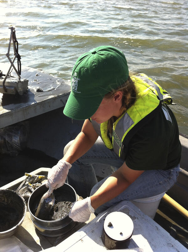
Female scientist digging sand from a bucket while on a boat in the water.
USGS Employee Sediment Sampling On Barnegat Bay, NJ After Super Storm

A USGS employee, is performing a sediment sampling on Barnegat Bay, NJ after Super Storm Sandy.