
Steaming continues on the 1980-1986 dome. View to the south and the east arm of Crater Glacier.
Images
Images related to Cascades Volcano Observatory.
Filter Total Items: 430

Steam vent near 1980-1986 dome, in the crater of Mount St. Helens.
Steaming continues on the 1980-1986 dome. View to the south and the east arm of Crater Glacier.

Fumerole near Mount St. Helens' 1980-86 dome
A fumerole near the 1980-86 dome keeps an open hole in the east arm of Crater Glacier. The hole is approximately 12 m (40 ft) in diameter, easily wide enough to hold a school bus and deep enough so you could not see the bus' top. View to the south.
A fumerole near the 1980-86 dome keeps an open hole in the east arm of Crater Glacier. The hole is approximately 12 m (40 ft) in diameter, easily wide enough to hold a school bus and deep enough so you could not see the bus' top. View to the south.

Monitoring channel erosion and aggradation, Mount St. Helens (North...
Fieldwork includes direct observations of changes to streams and stream beds to determine how changes will affect the downstream transportation of sediments. Here, the braided North Fork Toutle (left) joins Carbonate Springs Creek (right). View to the east.
Fieldwork includes direct observations of changes to streams and stream beds to determine how changes will affect the downstream transportation of sediments. Here, the braided North Fork Toutle (left) joins Carbonate Springs Creek (right). View to the east.

Field Studies at Mount St. Helens
Center for the Study of Active Volcanoes (CSAV) students Javier Pacheco (Costa Rica) and Syegi Kunrat (Indonesia) participate in field studies at Mount St. Helens.
Center for the Study of Active Volcanoes (CSAV) students Javier Pacheco (Costa Rica) and Syegi Kunrat (Indonesia) participate in field studies at Mount St. Helens.

Teachers take a guided walk on the Hummocks Trail at Mount St. Helens
Teachers take a guided walk on the Hummocks Trail, learning about the depositional features of the May 18, 1980 eruption.
Teachers take a guided walk on the Hummocks Trail, learning about the depositional features of the May 18, 1980 eruption.

Teachers learn about hummocks at Mount St. Helens workshop.
Todd Cullings, with the Mount St. Helens National Volcanic Monument, leads teachers in activities they can do with students before hiking the Hummocks Trail.
Todd Cullings, with the Mount St. Helens National Volcanic Monument, leads teachers in activities they can do with students before hiking the Hummocks Trail.

Maintenance at the Sep. Lobe Monitoring Station at Mount St. Helens.
The September Lobe monitoring station is part of the network of monitoring stations that detects and reports subtle changes in the volcanic vent area. At 2150 m (about 7100 ft) elevation, maintenance is performed during good weather to keep the station fully functional.
The September Lobe monitoring station is part of the network of monitoring stations that detects and reports subtle changes in the volcanic vent area. At 2150 m (about 7100 ft) elevation, maintenance is performed during good weather to keep the station fully functional.

Cascades Volcano Observatory (CVO) staff in front of the CVO office...
Cascades Volcano Observatory (CVO) staff in front of the CVO office building in Vancouver, Washington, May 1, 2018
Cascades Volcano Observatory (CVO) staff in front of the CVO office building in Vancouver, Washington, May 1, 2018

Rime ice coats telemetry system at Mount St. Helens.
To monitor volcanoes, scientists rely on remote monitoring equipment that can operate 24-hours a day and 365-days a year to deliver real-time data. When scientists design and install monitoring stations, they must consider the remoteness of sites, terrain, and winter conditions. Here, rime ice coats a telemetry system that transmits data near Mount St.
To monitor volcanoes, scientists rely on remote monitoring equipment that can operate 24-hours a day and 365-days a year to deliver real-time data. When scientists design and install monitoring stations, they must consider the remoteness of sites, terrain, and winter conditions. Here, rime ice coats a telemetry system that transmits data near Mount St.

Lakes and drainages within the watershed of Mount St. Helens.
Lakes and drainages within the watershed of Mount St. Helens.
Lakes and drainages within the watershed of Mount St. Helens.

Middle Sister volcano's east face with shingled stacks of thin lava...
The east face of Middle Sister is 350 m (1150 ft) high. Ice-sculpted pile of lavas at right, variously called "Black Hump," "Prouty Point," or "Step Sister," has 190 m of relief and consists of at least five flows.
The east face of Middle Sister is 350 m (1150 ft) high. Ice-sculpted pile of lavas at right, variously called "Black Hump," "Prouty Point," or "Step Sister," has 190 m of relief and consists of at least five flows.

Mount St. Helens and the industrial waterfront area of North Portla...
Mount St. Helens and the industrial waterfront area of North Portland, Oregon along the Willamette River in the foreground. Excess sediment from volcanoes can significantly impact river traffic.
Mount St. Helens and the industrial waterfront area of North Portland, Oregon along the Willamette River in the foreground. Excess sediment from volcanoes can significantly impact river traffic.

Logs Floating in Spirit Lake, Mount St. Helens in the background.
Logs float in Spirit Lake near the Spirit Lake gaging station and outflow tunnel. View is to the south with Mount St. Helens in the background.
Logs float in Spirit Lake near the Spirit Lake gaging station and outflow tunnel. View is to the south with Mount St. Helens in the background.

North Fork Toutle River, Sediment Retention Struct., Mount St. Helens
The May 18, 1980 eruption of Mount St. Helens had a dramatic impact on the North Fork Toutle River. The debris avalanche, lateral blast and ashfall produced a substantial amount of sediment, which continues to be washed into the river and transported downstream.
The May 18, 1980 eruption of Mount St. Helens had a dramatic impact on the North Fork Toutle River. The debris avalanche, lateral blast and ashfall produced a substantial amount of sediment, which continues to be washed into the river and transported downstream.

Mapping the North Fork Toutle River using a terrestrial laser scann...
The USGS, in collaboration with UNAVCO and the University of Colorado, uses these data to measure channel erosion and deposition in the reach.
The USGS, in collaboration with UNAVCO and the University of Colorado, uses these data to measure channel erosion and deposition in the reach.
USGS geologist uses a UV spectrometer to detect gases from a fumarole
USGS geologist uses a UV spectrometer to detect gases from fumarole at Crater Rock, Mount Hood.
USGS geologist uses a UV spectrometer to detect gases from fumarole at Crater Rock, Mount Hood.

Water depth measurements at Spirit Lake, Mount St. Helens, using ac...
Back at the USGS Cascades Volcano Observatory office, these data are merged with airborne LiDAR data to calculate lake volume.
Back at the USGS Cascades Volcano Observatory office, these data are merged with airborne LiDAR data to calculate lake volume.

Rime ice coats telemetry station north of Mount St. Helens, WA
Volcano monitoring stations must be designed to withstand harsh winter conditions.
Volcano monitoring stations must be designed to withstand harsh winter conditions.

Mount Rainier rises above Tacoma, WA and boat harbor, which may be ...
Mount Rainier rises above Tacoma, Washington and boat harbor, which may be impacted during the next eruption of the volcano.
Mount Rainier rises above Tacoma, Washington and boat harbor, which may be impacted during the next eruption of the volcano.

Extent of Newberry lavas including approximate ages of surficial flows
Extending approximately 75 miles north to south and 27 miles east to west, Newberry Volcano and its broad apron of lavas (light yellow shaded area) cover a total area of almost 1,200 square miles, making it the largest volcano of the Cascades volcanic chain. Its lavas stretch north beyond Smith Rock State Park, and south almost to Fort Rock State Natural Area.
Extending approximately 75 miles north to south and 27 miles east to west, Newberry Volcano and its broad apron of lavas (light yellow shaded area) cover a total area of almost 1,200 square miles, making it the largest volcano of the Cascades volcanic chain. Its lavas stretch north beyond Smith Rock State Park, and south almost to Fort Rock State Natural Area.

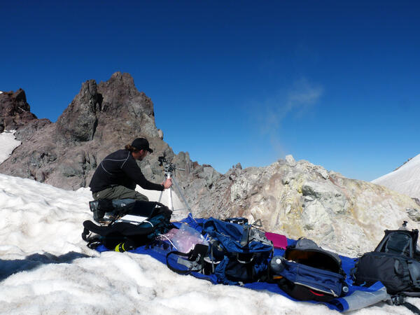
Stream channel cross-section measurements—instrument that uses lase...
Stream channel cross-section measurements—instrument that uses laser pulses to survey distance to a reflector operated by a second crew member, Mount St. Helens.
Stream channel cross-section measurements—instrument that uses laser pulses to survey distance to a reflector operated by a second crew member, Mount St. Helens.