
Global Positioning System receiver (called a GPS monument) at North Rim Station, a monitoring location at Newberry volcano, Oregon.
Images
Images related to Cascades Volcano Observatory.
Filter Total Items: 430
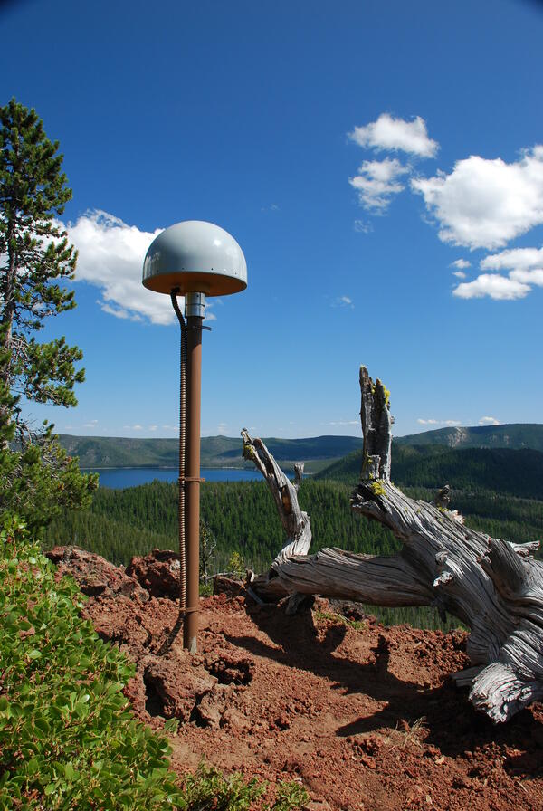
Global Positioning System receiver (called a GPS monument) at North...
Global Positioning System receiver (called a GPS monument) at North Rim Station, a monitoring location at Newberry volcano, Oregon.

Newberry caldera with Paulina Peak, Big Obsidian Flow and Paulina Lake
View looking south across Newberry caldera towards the Big Obsidian flow (left of center) and Paulina Peak, with Paulina Lake in foreground. Photo taken from the north rim of the caldera.
View looking south across Newberry caldera towards the Big Obsidian flow (left of center) and Paulina Peak, with Paulina Lake in foreground. Photo taken from the north rim of the caldera.

Gas sampling with CO2 Infrared Spectrometer at Mount St. Helens
Gas sampling with a CO2 Infrared Spectrometer at Mount St. Helens' September Lobe lava dome, Washington.
Gas sampling with a CO2 Infrared Spectrometer at Mount St. Helens' September Lobe lava dome, Washington.

Mt. St. Helens viewed at sunset
View of Mt. St. Helens at sunset, taken sometime after the crater forming eruption in 1980.
View of Mt. St. Helens at sunset, taken sometime after the crater forming eruption in 1980.
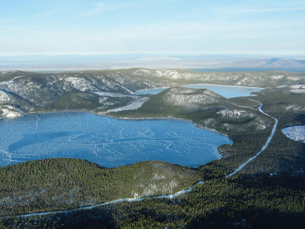
Aerial view of lakes and cinder cone at Newberry Volcano Caldera.
A view looking northeast across the central caldera of Newberry Volcano. Paulina Lake is in the foreground and East Lake is in the distance. The Central Pumice Cone lies between the two lakes. Near the bottom of the photo at the south edge of Paulina Lake, the two hills are named the Lakeshore Domes.
A view looking northeast across the central caldera of Newberry Volcano. Paulina Lake is in the foreground and East Lake is in the distance. The Central Pumice Cone lies between the two lakes. Near the bottom of the photo at the south edge of Paulina Lake, the two hills are named the Lakeshore Domes.

Mount Baker's NEern face, WA.
Mount Baker's northeastern face, Washington.
Mount Baker's northeastern face, Washington.

Suspended sediment sample collection from the North Fork Toutle Riv...
Suspended sediment sample collection from the North Fork Toutle River above the Sediment Retention Structure, downstream from Mount St. Helens.
Suspended sediment sample collection from the North Fork Toutle River above the Sediment Retention Structure, downstream from Mount St. Helens.

Mount St. Helens, as viewed from Coldwater Ridge around sunset.
Mount St. Helens, as viewed from Coldwater Ridge around sunset.
Mount St. Helens, as viewed from Coldwater Ridge around sunset.

Seismic station VALT in Mount St. Helens crater, view toward the south
Seismic station VALT in Mount St. Helens crater, view toward the south.
Seismic station VALT in Mount St. Helens crater, view toward the south.

Lake elevation monitoring gage on Spirit Lake, Mount St. Helens. Do...
The USGS operates a real-time lake elevation monitoring gage on Spirit Lake to ensure water level does not exceed a safe limit. In 1985, the U.S.
The USGS operates a real-time lake elevation monitoring gage on Spirit Lake to ensure water level does not exceed a safe limit. In 1985, the U.S.

Helicopter dropping off monitoring equipment at Mount St. Helens, WA.
Helicopter dropping off monitoring equipment at Mount St. Helens, Washington.
Helicopter dropping off monitoring equipment at Mount St. Helens, Washington.

Sun Creek Valley with Crater Lake in background, aerial view lookin...
Morning aerial view looking northwest up the valley of Sun Creek. Applegate Peak caps the prominent rock wall of the west side of Sun Notch at the caldera rim. Northwest caldera wall is visible on opposite side of Crater Lake through Sun Notch. Grayback Ridge in foreground is thick lava of pre-Mazama rhyodacite (410-460 ka).
Morning aerial view looking northwest up the valley of Sun Creek. Applegate Peak caps the prominent rock wall of the west side of Sun Notch at the caldera rim. Northwest caldera wall is visible on opposite side of Crater Lake through Sun Notch. Grayback Ridge in foreground is thick lava of pre-Mazama rhyodacite (410-460 ka).

Eruptions in the Cascade Range during the past 4000 years. USGS GIP 64
Eruptions in the Cascade Range during the past 4000 years. USGS GIP 64
Eruptions in the Cascade Range during the past 4000 years. USGS GIP 64

North Sister volcano's east face (750 m, 2460 ft high) consists of ...
East face of North Sister, 750 m high. Consists of about 100 thin mafic lava flows and intercalated layers of red scoria, capped by thick summit lava flows. Remnant of Thayer Glacier feeds cirque lake. Pervasively altered yellow-orange buttress on right, 250 m thick, consists of east-dipping, palagonitized, ash-rich fragmental flow deposits.
East face of North Sister, 750 m high. Consists of about 100 thin mafic lava flows and intercalated layers of red scoria, capped by thick summit lava flows. Remnant of Thayer Glacier feeds cirque lake. Pervasively altered yellow-orange buttress on right, 250 m thick, consists of east-dipping, palagonitized, ash-rich fragmental flow deposits.

South Sister volcano's northeast face with stacks of andesite lava flows and oxidized (red colored) scoria.
linkProuty Glacier headwall on the northeast face of South Sister. Dipping stacks of lava and scoria were excavated by Prouty Glacier, exposing cross-sectional views of the last 33,000 years of summit activity. The 350-m-thick (11,500-ft) lava stacks are truncated at about 3000 m (9,800 ft) elevation, forming the ragged rim of a broad paleocrater.

South Sister's northwest summit, basaltic andesite lava and scoria cap the volcano.
Lost Creek Glacier and its cirque are in the center, and Eugene Glacier and its cirque are toward the bottom left. Fingerlike lobes of dacite lava dribble down northwest ridge atop fragmental deposit and beneath capping agglutinate. The entire edifice visible here was built between 30 and 20 ka.
Lost Creek Glacier and its cirque are in the center, and Eugene Glacier and its cirque are toward the bottom left. Fingerlike lobes of dacite lava dribble down northwest ridge atop fragmental deposit and beneath capping agglutinate. The entire edifice visible here was built between 30 and 20 ka.

LUSI mud volcano, East Java, Indonesia
The LUSI (Lumpur “mud”-Sidoarjo) mud volcano in East Java, Indonesia, has been erupting mud and gases since 2006. Eruption rates can be as high as 160,000 m3 per day, and the mud has displaced tens of thousands of people and caused billions of dollars in damage. USGS photo by Tom Casadevall, 2007.
The LUSI (Lumpur “mud”-Sidoarjo) mud volcano in East Java, Indonesia, has been erupting mud and gases since 2006. Eruption rates can be as high as 160,000 m3 per day, and the mud has displaced tens of thousands of people and caused billions of dollars in damage. USGS photo by Tom Casadevall, 2007.

Western edge of Sherman Crater in the foreground of the Mount Baker...
Western edge of Sherman Crater in the foreground of the Mount Baker Summit, Washington, view slightly northwestward.
Western edge of Sherman Crater in the foreground of the Mount Baker Summit, Washington, view slightly northwestward.

Scientist observing Mount St. Helens' crater and dome
USGS scientist observing Mount St. Helens' crater and dome from the Brutus Camera station.
USGS scientist observing Mount St. Helens' crater and dome from the Brutus Camera station.

Mount Adams western profile as seen from Mount St. Helens.
Mount Adams western profile as seen from Mount St. Helens.
Mount Adams western profile as seen from Mount St. Helens.

Monitoring station VALT was installed on the crater floor of Mount St. Helens in 2006.
Monitoring station VALT was installed on the crater floor of Mount St. Helens in 2006. It was called VALT because a vault-like structure about the size of a large doghouse was built into the rocky deposits to protect the state-of-the-art (at that time) broadband seismometer from environmental variables such as temperature and humidity.
Monitoring station VALT was installed on the crater floor of Mount St. Helens in 2006. It was called VALT because a vault-like structure about the size of a large doghouse was built into the rocky deposits to protect the state-of-the-art (at that time) broadband seismometer from environmental variables such as temperature and humidity.