
Record section showing horizontal component seismograms from stations in the Yellowstone region from the M4.8 earthquake that occurred near Norris Geyser Basin on March 30, 2014. The vertical blue dashed line represents the origin time of the earthquake at 12:34:39.16 UTC. The red line represents the P-wave arrival with a velocity of ~5.7 km/s. The
Images
Images related to Yellowstone Volcano Observatory.
Filter Total Items: 528

Seismograms showing Yellowstone M4.8 earthquake on March 30, 2014
Record section showing horizontal component seismograms from stations in the Yellowstone region from the M4.8 earthquake that occurred near Norris Geyser Basin on March 30, 2014. The vertical blue dashed line represents the origin time of the earthquake at 12:34:39.16 UTC. The red line represents the P-wave arrival with a velocity of ~5.7 km/s. The

Photos taken from helicopter over Mammoth Hot Springs
Top: Examples of some of the photos taken from helicopter over Mammoth Hot Springs in September 2013. Photos taken by Hank Heasler. Bottom: Hill-shade image calculated from the 2013 DEM over Mammoth Hot Springs and that was derived from a series of overlapping photos using Structure-from-Motion photogrammetry.
Top: Examples of some of the photos taken from helicopter over Mammoth Hot Springs in September 2013. Photos taken by Hank Heasler. Bottom: Hill-shade image calculated from the 2013 DEM over Mammoth Hot Springs and that was derived from a series of overlapping photos using Structure-from-Motion photogrammetry.

Huckleberry Ridge Tuff deposit, Yellowstone
Huckleberry Ridge Tuff deposit exposed on Mt. Everts, near the northern boundary of Yellowstone National Park. The deposit was created by ash falling from the plume early in the eruption sequence, 2.08 million years ago. Photo by Madison Myers, Montana State University.
Huckleberry Ridge Tuff deposit exposed on Mt. Everts, near the northern boundary of Yellowstone National Park. The deposit was created by ash falling from the plume early in the eruption sequence, 2.08 million years ago. Photo by Madison Myers, Montana State University.

Photo of the Old Faithful Inn lobby
Photo of the Old Faithful Inn lobby, which features a six-story-tall fireplace and chimney made from rocks quarried form a rhyolite lava flow in Yellowstone. NPS photo by Jim Peaco, July 22, 2013.
Photo of the Old Faithful Inn lobby, which features a six-story-tall fireplace and chimney made from rocks quarried form a rhyolite lava flow in Yellowstone. NPS photo by Jim Peaco, July 22, 2013.

Huckleberry Ridge Tuff fall deposits at Mount Everts, Yellowstone
View of ripples caused by wind winnowing of the Huckleberry Ridge Tuff fall deposits at Mount Everts. Other layers below show evidence for rain and hail landing with the falling ash. Scale in centimeters and inches.
View of ripples caused by wind winnowing of the Huckleberry Ridge Tuff fall deposits at Mount Everts. Other layers below show evidence for rain and hail landing with the falling ash. Scale in centimeters and inches.

View north along U.S. Route 20 from near Ashton, ID, at the margin of the Huckleberry Ridge Tuff in the distance
linkGoogle maps photo taken just north of Ashton, ID, along U.S. Route 20. The photo was taken looking north towards Island Park, ID. The forested ridge in the distance marks the margin of a caldera that formed 2.08 million years ago, when the Huckleberry Ridge Tuff erupted.

Mud Geyser, Yellowstone
Steam rises from the Mud Geyser fumarole on the northeast side of the Mud Volcano thermal area in Yellowstone National Park. Gas that discharges from Mud Geyser has the most magmatic character of any sampled feature in Yellowstone.
Steam rises from the Mud Geyser fumarole on the northeast side of the Mud Volcano thermal area in Yellowstone National Park. Gas that discharges from Mud Geyser has the most magmatic character of any sampled feature in Yellowstone.
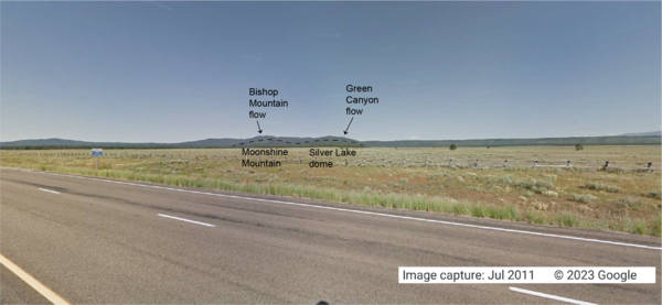
Looking west from the intersection of U.S. Route 20 and Old Hwy 47, in Idaho, at lava flows associated with the Henrys Fork caldera
linkGoogle Maps photo taken at the intersection of U.S. Route 20 and Old Hwy 47 in Idaho, looking west. The tops of Moonshine Mountain and Silver Lake dome, rhyolite lava flows located inside the caldera, are indicated with a dashed black line.

Cross section through the trunk of a Yellowstone lodgepole pine
Cross section through the trunk of a lodgepole pine tree from Cooking Hillside near Mud Volcano, Yellowstone National Park. The earliest date for this tree is 1916 and it died in 1990. Spongy white-gray areas are foam insulation that was injected into the sample to reinforce the structure of the wood.
Cross section through the trunk of a lodgepole pine tree from Cooking Hillside near Mud Volcano, Yellowstone National Park. The earliest date for this tree is 1916 and it died in 1990. Spongy white-gray areas are foam insulation that was injected into the sample to reinforce the structure of the wood.

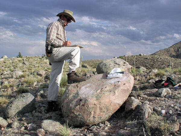
Grey’s Landing Ignimbrite in Idaho part of Yellowstone Hotspot
The Grey’s Landing Ignimbrite in Idaho (Dr. Thomas Knott, of the University of Leicester, England, gives the scale of the cliff). The entire cliff (and more not seen!) would have been deposited in a matter of moments as it welded to the land surface during a super eruption about 8.7 million years ago.
The Grey’s Landing Ignimbrite in Idaho (Dr. Thomas Knott, of the University of Leicester, England, gives the scale of the cliff). The entire cliff (and more not seen!) would have been deposited in a matter of moments as it welded to the land surface during a super eruption about 8.7 million years ago.

Geysers on the south pole of Saturn's moon Enceladus
This two-image mosaic is one of the highest resolution views acquired by the Cassini spacecraft during its imaging survey of the geyser basin capping the southern hemisphere of Saturn's moon Enceladus.
This two-image mosaic is one of the highest resolution views acquired by the Cassini spacecraft during its imaging survey of the geyser basin capping the southern hemisphere of Saturn's moon Enceladus.

Photo of the Madison Museum, Yellowstone National Park
Photo of the Madison Museum, built in 1930 and designed by Herbert Maier. This structure exemplifies the National Park Rustic style, using natural materials and artisan craftmanship that are intended to blend buildings into the surrounding environment, “suggesting the smallness of man in relation to nature” (Herbert Maier).
Photo of the Madison Museum, built in 1930 and designed by Herbert Maier. This structure exemplifies the National Park Rustic style, using natural materials and artisan craftmanship that are intended to blend buildings into the surrounding environment, “suggesting the smallness of man in relation to nature” (Herbert Maier).

Ken Pierce providing geology lesson during field trip Jackson Hole
Ken Pierce, at the Curtis Canyon Overlook in Jackson Hole, leading the 2003 INQUA (International Union of Quaternary Research) field trip, one of his many geologic field trips about the Greater Yellowstone Geoecosystem.
Ken Pierce, at the Curtis Canyon Overlook in Jackson Hole, leading the 2003 INQUA (International Union of Quaternary Research) field trip, one of his many geologic field trips about the Greater Yellowstone Geoecosystem.
Ken Pierce in the field with large glacial erratic
Ken Pierce in the field with a large glacial erratic in the Clarks Fork moraines taking detailed notes and annotating a map in progress.
Ken Pierce in the field with a large glacial erratic in the Clarks Fork moraines taking detailed notes and annotating a map in progress.

Bob Fournier measuring the gas-to-water ratio (gas/steam) at drill site Y2 in Yellowstone National Park
linkBob Fournier measuring the gas-to-water ratio (gas/steam) at drill site Y2, near Hot Lake on Firehole Lake Drive in Lower Geyser Basin, Yellowstone National Park, in the late 1960s. USGS Photo.

Hydrothermal explosion at Biscuit Basin in YNP. These types of even...
Hydrothermal explosion at Biscuit Basin in Yellowstone National Park. These types of events are the most likely explosive hazard from the Yellowstone Volcano.
Hydrothermal explosion at Biscuit Basin in Yellowstone National Park. These types of events are the most likely explosive hazard from the Yellowstone Volcano.

An inquisitive Yellow-bellied Marmot stands on its hind legs, in Yellowstone National Park.
Yellow-bellied Marmot stands on its hind legs in Yellowstone National Park. Photo by D. Dzurisin.
Yellow-bellied Marmot stands on its hind legs in Yellowstone National Park. Photo by D. Dzurisin.

Installing geophysical boreholes in Yellowstone
UNAVCO engineers drilling a borehole for instrument installation (left). Aerial view of borehole casing used to protect instruments from the elements found below the surface (right).
UNAVCO engineers drilling a borehole for instrument installation (left). Aerial view of borehole casing used to protect instruments from the elements found below the surface (right).

Terrace Springs, northeast of Madison Junction, Yellowstone National Park
The water at Terrace Springs, northeast of Madison Junction in Yellowstone National Park, is relatively cold (about 60 °C or 140 °F), but the water is still saturated with CO2-rich bubbles. Photo by Shaul Hurwitz in September 2008.
The water at Terrace Springs, northeast of Madison Junction in Yellowstone National Park, is relatively cold (about 60 °C or 140 °F), but the water is still saturated with CO2-rich bubbles. Photo by Shaul Hurwitz in September 2008.

Narrow Gauge spring, Mammoth Hot Springs, Yellowstone National Park
Narrow Gauge spring, Mammoth Hot Springs, Yellowstone National Park. Vent area is between the two trees on top of the travertine deposits. Terraced pools form due to deposition of travertine from the fluids as they cool and degas carbon dioxide.
Narrow Gauge spring, Mammoth Hot Springs, Yellowstone National Park. Vent area is between the two trees on top of the travertine deposits. Terraced pools form due to deposition of travertine from the fluids as they cool and degas carbon dioxide.

Strike-slip earthquake focal mechanism
Left hand plot shows a focal mechanism from an earthquake where the fault is horizontal (red line), and the motion is right-lateral strike skip. The initial direction of wave motion (either back toward the source or away from the source is shown by the arrows. Right hand plot shows the associated beachball diagram, with compressional (“C”) and tensional
Left hand plot shows a focal mechanism from an earthquake where the fault is horizontal (red line), and the motion is right-lateral strike skip. The initial direction of wave motion (either back toward the source or away from the source is shown by the arrows. Right hand plot shows the associated beachball diagram, with compressional (“C”) and tensional