
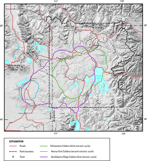
Digital elevation model of Yellowstone National Park and vicinity, showing the location of the calderas formed during each of Yellowstone’s three most recent volcanic cycles. The youngest caldera-forming eruption produced Yellowstone Caldera (green line), located within Yellowstone National Park.
Images
Images related to Yellowstone Volcano Observatory.
Filter Total Items: 528
Digital elevation model of Yellowstone National Park and vicinity
Digital elevation model of Yellowstone National Park and vicinity, showing the location of the calderas formed during each of Yellowstone’s three most recent volcanic cycles. The youngest caldera-forming eruption produced Yellowstone Caldera (green line), located within Yellowstone National Park.

Contact between Huckleberry Ridge Tuff ignimbrite members B and C
The contact (red arrow) between Huckleberry Ridge Tuff ignimbrite members B and C is marked by a time break of probably years to a few decades.
The contact (red arrow) between Huckleberry Ridge Tuff ignimbrite members B and C is marked by a time break of probably years to a few decades.

Southern tip of the Lemhi Range, eastern Snake River Plain. showing the wall of the Blue Creek caldera
linkSouthern tip of the Lemhi Range on the northeastern margin of the eastern Snake River Plain showing the caldera wall of the 6.27 million year old Blue Creek caldera, in the Heise volcanic field. Also shown are other units from the Heise volcanic field including the Kilgore Tuff and the Blacktail Creek Tuff. In the foreground is the much thicker sequence

Eruption of Daisy Geyser, Yellowstone National Park
An eruption of Daisy Geyser in the Upper Geyser Basin of Yellowstone National Park. The geyser erupts boiling water at about 93 °C (200 °F). Photo by Shaul Hurwitz on April 12, 2007.
An eruption of Daisy Geyser in the Upper Geyser Basin of Yellowstone National Park. The geyser erupts boiling water at about 93 °C (200 °F). Photo by Shaul Hurwitz on April 12, 2007.

Air photo showing newly thermal areas on Mallard Lake resurgent dome
National Agriculture Imagery Program natural-color image from September 9, 2006, showing newly mapped thermal areas (outlined in yellow) on the north side of the Mallard Lake resurgent dome.
National Agriculture Imagery Program natural-color image from September 9, 2006, showing newly mapped thermal areas (outlined in yellow) on the north side of the Mallard Lake resurgent dome.

Guardian Geyser and Norris Geyser Basin, Yellowstone National Park
Guardian Geyser and Norris Geyser Basin, Yellowstone National Park.
Guardian Geyser and Norris Geyser Basin, Yellowstone National Park.

Excelsior Geyser and Grand Prismatic Spring, Yellowstone
Aerial view of Excelsior Geyser (in the foreground) and Grand Prismatic Spring in Yellowstone’s Midway Geyser Basin. The colors around the thermal features are locations of different thermophile communities. These thermophiles fix carbon, both from the atmosphere and from the hot water. Credit Jim Peaco; June 22, 2006; Catalog #20386d; Original #IT8M4075
Aerial view of Excelsior Geyser (in the foreground) and Grand Prismatic Spring in Yellowstone’s Midway Geyser Basin. The colors around the thermal features are locations of different thermophile communities. These thermophiles fix carbon, both from the atmosphere and from the hot water. Credit Jim Peaco; June 22, 2006; Catalog #20386d; Original #IT8M4075

Old Faithful in eruption
Old Faithful Geyser in eruption. Under Yellowstone Research Permit YELL-SCI-8030, 13 mineralized wood specimens were collected from the geyser mound. The dates of the mineralized wood samples imply that such eruptions did not take place for over a century between the mid-13th to mid-14th centuries.
Old Faithful Geyser in eruption. Under Yellowstone Research Permit YELL-SCI-8030, 13 mineralized wood specimens were collected from the geyser mound. The dates of the mineralized wood samples imply that such eruptions did not take place for over a century between the mid-13th to mid-14th centuries.

Rangers attempting to clean trash out of Morning Glory Pool in 1975.
Rangers attempting to clean trash out of Morning Glory Pool in September 1975. National Park Service photograph Dan Ing.
Rangers attempting to clean trash out of Morning Glory Pool in September 1975. National Park Service photograph Dan Ing.

Aerial (balloon) view of Norris Geyser Basin, Yellowstone National Park, looking northwest from the south
linkAerial (balloon) view of Norris Geyser Basin, Yellowstone National Park, looking northwest from the south. USGS Photo by Brita Graham Wall, 2005.
Aerial (balloon) view of Norris Geyser Basin, Yellowstone National Park, looking northwest from the south
linkAerial (balloon) view of Norris Geyser Basin, Yellowstone National Park, looking northwest from the south. USGS Photo by Brita Graham Wall, 2005.

Grand Prismatic Spring, Midway Geyser Basin, Yellowstone National Park
Grand Prismatic Spring, Midway Geyser Basin, Yellowstone National Park. Grand Prismatic is the largest hot spring in Yellowstone and the third largest in the world. Photograph by Robert Fournier.
Grand Prismatic Spring, Midway Geyser Basin, Yellowstone National Park. Grand Prismatic is the largest hot spring in Yellowstone and the third largest in the world. Photograph by Robert Fournier.
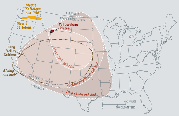
Map of the known ash-fall boundaries for several U.S. eruptions
Eruptions of the Yellowstone volcanic system have included the two largest volcanic eruptions in North America in the past few million years; the third largest was at Long Valley in California and produced the Bishop ash bed. The biggest of the Yellowstone eruptions occurred 2.1 million years ago, depositing the Huckleberry Ridge ash bed.
Eruptions of the Yellowstone volcanic system have included the two largest volcanic eruptions in North America in the past few million years; the third largest was at Long Valley in California and produced the Bishop ash bed. The biggest of the Yellowstone eruptions occurred 2.1 million years ago, depositing the Huckleberry Ridge ash bed.

Heise cliffs, the type location for the 4.45–7.0 million year old Heise Volcanic Field
Heise cliffs, the type location for the 4.45–7.0 million year old Heise Group from the Heise volcanic field, which preceded the Yellowstone Plateau volcanic field. Most of the cliffs exposed here are rhyolitic, densely welded, rhyolitic pyroclastic density flow deposits. USGS Photo by L. A. Morgan (May 2005).
Heise cliffs, the type location for the 4.45–7.0 million year old Heise Group from the Heise volcanic field, which preceded the Yellowstone Plateau volcanic field. Most of the cliffs exposed here are rhyolitic, densely welded, rhyolitic pyroclastic density flow deposits. USGS Photo by L. A. Morgan (May 2005).

Map showing earthquake focal mechanisms in the Yellowstone region
Map showing earthquake focal mechanisms in the Yellowstone region.
Map showing earthquake focal mechanisms in the Yellowstone region.

Exposure of rhyolite volcanic rocks in the central Snake River Plain
Exposure of rhyolite volcanic rocks in the central Snake River Plain showing a thick sequence of 10-12 million-year-old, densely welded, pyroclastic density flow units (darker units from middle of photo to top of hill) overlying a thick sequence of white, friable, ash fall deposits. USGS Photo by L. A. Morgan (May 2004).
Exposure of rhyolite volcanic rocks in the central Snake River Plain showing a thick sequence of 10-12 million-year-old, densely welded, pyroclastic density flow units (darker units from middle of photo to top of hill) overlying a thick sequence of white, friable, ash fall deposits. USGS Photo by L. A. Morgan (May 2004).

Densely welded rhyolites from the central Snake River Plain
Densely welded rhyolites from the central Snake River Plain. USGS Photo by L. A. Morgan (May 2004).
Densely welded rhyolites from the central Snake River Plain. USGS Photo by L. A. Morgan (May 2004).

Sheepeater Cliff, in Yellowstone National Park
Slow cooling of a basaltic lava flow that was erupted about 500,000 years ago resulted in the formation of hexagonal columns at Sheepeater Cliff, in Yellowstone National Park.
Slow cooling of a basaltic lava flow that was erupted about 500,000 years ago resulted in the formation of hexagonal columns at Sheepeater Cliff, in Yellowstone National Park.

Columnar-jointed lava flow in the wall of the Yellowstone River canyon
A 1.5-million-year-old basaltic lava flow in the canyon wall of the Yellowstone River as viewed from Calcite Springs Overlook near Tower Junction in Yellowstone National Park. Slow cooling of this lava flow resulted in the formation of vertical columns. Glacial gravels are present above and below the lava flow.
A 1.5-million-year-old basaltic lava flow in the canyon wall of the Yellowstone River as viewed from Calcite Springs Overlook near Tower Junction in Yellowstone National Park. Slow cooling of this lava flow resulted in the formation of vertical columns. Glacial gravels are present above and below the lava flow.

Angel Terrace, Mammoth Hot Springs, Yellowstone National Park
Angel Terrace, Mammoth Hot Springs, Yellowstone National Park. Travertine deposits are abundant in the area. Photo by JoAnn Holloway, 2003.
Angel Terrace, Mammoth Hot Springs, Yellowstone National Park. Travertine deposits are abundant in the area. Photo by JoAnn Holloway, 2003.

Gas bubbles through a sample bottle containing alkaline solution
Gas bubbles through a sample bottle containing alkaline solution, allowing for separation of different gas phases.
Gas bubbles through a sample bottle containing alkaline solution, allowing for separation of different gas phases.

Bathymetric map of Yellowstone Lake
Bathymetric map of Yellowstone Lake showing hydrothermal features in the north part of the lake, including Elliott's Crater, Mary Bay, and Deep Hole. Colors correspond to lake depth, with cooler colors indicating greater depths.
Bathymetric map of Yellowstone Lake showing hydrothermal features in the north part of the lake, including Elliott's Crater, Mary Bay, and Deep Hole. Colors correspond to lake depth, with cooler colors indicating greater depths.