
Kentucky mount constructed from Speed Rail. This mount can be used to deploy Rio Grande, RiverPro, RioPro, and RiverSurveyor ADCPs.
Images
Explore our planet through photography and imagery, including climate change and water all the way back to the 1800s when the USGS was surveying the country by horse and buggy.
Filter Total Items: 21558

Kentucky Mount
Kentucky mount constructed from Speed Rail. This mount can be used to deploy Rio Grande, RiverPro, RioPro, and RiverSurveyor ADCPs.

Timelapse of water rising in Halema‘uma‘u
This timelapse sequence shows the water pond in Halema‘uma‘u Crater, at Kīlauea's summit, between November 1, 2019, and March 26, 2020. Over this time the water level rose approximately 14 meters (46 feet), equivalent to 67 cm (about 2 feet) per week. The timelapse shows one image per day (with a few cloudy images removed), and is looped several times.
This timelapse sequence shows the water pond in Halema‘uma‘u Crater, at Kīlauea's summit, between November 1, 2019, and March 26, 2020. Over this time the water level rose approximately 14 meters (46 feet), equivalent to 67 cm (about 2 feet) per week. The timelapse shows one image per day (with a few cloudy images removed), and is looped several times.

Davina Passeri presents poster about coastal change research
Davina Passeri of the St. Petersburg Coastal and Marine Science Center presents a poster about coastal change research in Dauphin Island, Alabama at the USGS Southeast Regional Meeting in February 2020.
Davina Passeri of the St. Petersburg Coastal and Marine Science Center presents a poster about coastal change research in Dauphin Island, Alabama at the USGS Southeast Regional Meeting in February 2020.

Ilsa Kuffner presents a poster on coral research
Ilsa Kuffner speaks to a group at the USGS Southeast Regional Meeting in February 2020 about coral research conducted by the St. Petersburg Coastal and Marine Science Center
Ilsa Kuffner speaks to a group at the USGS Southeast Regional Meeting in February 2020 about coral research conducted by the St. Petersburg Coastal and Marine Science Center

Field equipment for bathymetric and topographic surveys
Field equipment used by USGS Pacific Coastal and Marine Science Center scientists for bathymetric and topographic surveys in the Sacramento-San Joaquin Delta, California
Field equipment used by USGS Pacific Coastal and Marine Science Center scientists for bathymetric and topographic surveys in the Sacramento-San Joaquin Delta, California

Sediment laboratory at St. Petersburg Coastal & Marine Science Center
The USGS St. Petersburg Coastal and Marine Science Center strives to provide timely, robust science using modern methods and state-of-the-art technologies. This involves keeping our facilities and equipment updated.
The USGS St. Petersburg Coastal and Marine Science Center strives to provide timely, robust science using modern methods and state-of-the-art technologies. This involves keeping our facilities and equipment updated.

I-80 Underpass at Rawlins, WY
Hats off to the tireless efforts of WYDOT and county crews for all the plowing to get roads open so we can do our jobs.
Hats off to the tireless efforts of WYDOT and county crews for all the plowing to get roads open so we can do our jobs.

Road from Hanna to Elk Mountain
Hats off to the tireless efforts of WYDOT and county crews for all the plowing to get roads open so we can do our jobs.
Hats off to the tireless efforts of WYDOT and county crews for all the plowing to get roads open so we can do our jobs.

Drilling Holes on the Green River
Drilling holes to collect samples for water-quality analyses at Green River nr LaBarge was made extra challenging by a temperature of -10F. It takes a lot of planning and quick action to collect and process the sample before equipment and water freeze.
Drilling holes to collect samples for water-quality analyses at Green River nr LaBarge was made extra challenging by a temperature of -10F. It takes a lot of planning and quick action to collect and process the sample before equipment and water freeze.

Shoreline and dune-base forecast locations
Map and graphs illustrating (A) the extent of the shoreline and dune-base forecast locations (red). The year of (B) the first available and (C) most recent shoreline (red) and dune-base (blue) positions are provided for each transect. (D) Total number of shoreline and dune-base positions used in the analysis are also shown. #, number.
Map and graphs illustrating (A) the extent of the shoreline and dune-base forecast locations (red). The year of (B) the first available and (C) most recent shoreline (red) and dune-base (blue) positions are provided for each transect. (D) Total number of shoreline and dune-base positions used in the analysis are also shown. #, number.

Water, ash, and the great unknown of explosive volcanic eruptions
Scanning electron microprobe images show the complexity of tiny Icelandic ash grains (150 micron, or 0.006 inch). Image (a) shows a dense and blocky grain, and (b) shows a foamy grain. Photos by J. Schmith.
Scanning electron microprobe images show the complexity of tiny Icelandic ash grains (150 micron, or 0.006 inch). Image (a) shows a dense and blocky grain, and (b) shows a foamy grain. Photos by J. Schmith.

Frozen Dinwoody Creek
The stream at this site is free flowing under the ice, so the relation between stream stage and streamflow works like it does in the summer (or other non-ice months). Real-time flow and stage for Dinwoody Creek abv Lakes online: http://ow.ly/a0L850yr2Nb
The stream at this site is free flowing under the ice, so the relation between stream stage and streamflow works like it does in the summer (or other non-ice months). Real-time flow and stage for Dinwoody Creek abv Lakes online: http://ow.ly/a0L850yr2Nb

Shannon Fisher pulling sled at Moreau Lake
Photo Contest Winner | Feb. 2020 | People
Shannon Fisher pulling sled at Moreau Lake area after measuring water levels in GW wells surrounding the lake
Photo Contest Winner | Feb. 2020 | People
Shannon Fisher pulling sled at Moreau Lake area after measuring water levels in GW wells surrounding the lake

Salt flat at Death Valley
Photo Contest Winner | March 2020 | USGS at Work
Salt flat at Death Valley
Photo Contest Winner | March 2020 | USGS at Work
Salt flat at Death Valley

Land Use Change (1934 - 2005), Anza Valley, CA
Land use change in the Anza Valley, CA from 1934 to 2005.
Land use change in the Anza Valley, CA from 1934 to 2005.

Map of the super gage site locations in Ohio, Kentucky, and Indiana
Map of the super gage site locations in Ohio, Kentucky, and Indiana
Map of the super gage site locations in Ohio, Kentucky, and Indiana

Answer: a GPS capable of accurately measuring elevations to within 10 cm (~4 in)
Answer: a GPS capable of accurately measuring elevations to within 10 cm (~4 in). In the summer of 2019, USGS organized a Light Detection and Ranging (LiDAR) survey of the Kīlauea summit and East Rift Zone, including both the Pu‘u ‘Ō‘ō and 2018 lower Puna lava flows.
Answer: a GPS capable of accurately measuring elevations to within 10 cm (~4 in). In the summer of 2019, USGS organized a Light Detection and Ranging (LiDAR) survey of the Kīlauea summit and East Rift Zone, including both the Pu‘u ‘Ō‘ō and 2018 lower Puna lava flows.
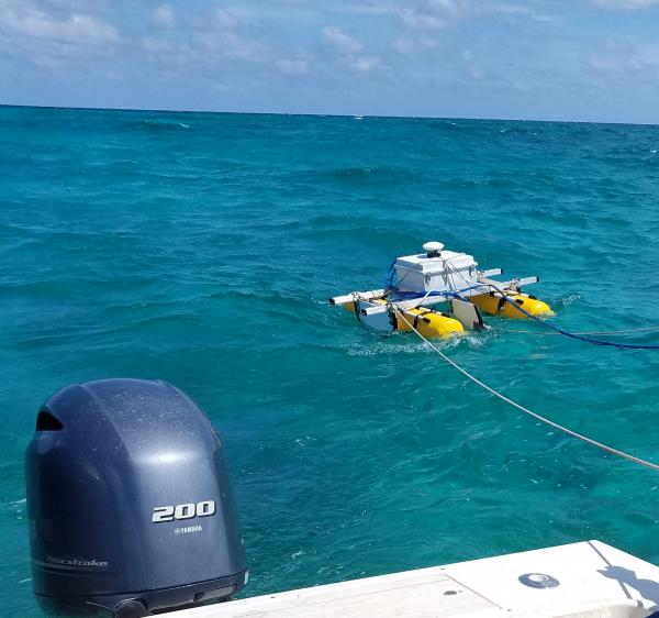
SQUID-5 - Structure-from-Motion Quantitative Underwater Imaging Device
The SQUID-5, or a Structure-from-Motion (SfM) Quantitative Underwater Imaging Device with 5 cameras is a towed surface vehicle with an onboard Global Navigation Satellite System (GNSS) and 5 downward-looking cameras with overlapping views of the seafloor.
The SQUID-5, or a Structure-from-Motion (SfM) Quantitative Underwater Imaging Device with 5 cameras is a towed surface vehicle with an onboard Global Navigation Satellite System (GNSS) and 5 downward-looking cameras with overlapping views of the seafloor.

Winter discharge at Fivemile Creek
Streamflow and water-quality data have been collected at Fivemile Creek near Shoshoni since the 1940s. All data available on line at: http://ow.ly/uraY50ylvIi
Streamflow and water-quality data have been collected at Fivemile Creek near Shoshoni since the 1940s. All data available on line at: http://ow.ly/uraY50ylvIi

State of Our Nation’s Coast Stakeholder Engagement Workshop
Participants of the Coastal Change Hazards State of Our Nation’s Coast stakeholder engagement workshop at the Waquoit Bay National Estuarine Reserve in Falmouth, MA. Participants are pictured here talking in small groups.
Participants of the Coastal Change Hazards State of Our Nation’s Coast stakeholder engagement workshop at the Waquoit Bay National Estuarine Reserve in Falmouth, MA. Participants are pictured here talking in small groups.

Drilling Through the Ice at Muddy Creek
It took all of the auger flight plus a little to get through ice to the creek. Collecting sample no. 238 from Muddy Ck nr Shoshoni. Monthly samples create a data set that can be used to describe water quality during different seasons and over time.
It took all of the auger flight plus a little to get through ice to the creek. Collecting sample no. 238 from Muddy Ck nr Shoshoni. Monthly samples create a data set that can be used to describe water quality during different seasons and over time.