
Dark image of Isla Verde in San Juan, Puerto Rico, from a coastal video monitoring station. Image is compiled from 10 minutes of video and tracks the darkest pixels through 10 minutes of motion.
Images
Images intro.
Filter Total Items: 2135

Isla Verde Video Camera 4 Dark Image
Dark image of Isla Verde in San Juan, Puerto Rico, from a coastal video monitoring station. Image is compiled from 10 minutes of video and tracks the darkest pixels through 10 minutes of motion.

Sunset State Beach variance image
Image from video camera along Sunset State Beach in Watsonville, CA, looking northwest. Every half hour during daylight hours, the camera shoots video for 10 minutes.
Image from video camera along Sunset State Beach in Watsonville, CA, looking northwest. Every half hour during daylight hours, the camera shoots video for 10 minutes.

Instrument check at a tidal creek, Falmouth, MA
Meagan Gonneea checks on instruments at a tidal creek in Great Pond, Falmouth, MA. Daily tides drive exchange between coastal wetlands and adjacent estuaries. Here we have instrumented a tidal channel to measure those fluxes over a tidal cycle. When the marsh floods, material is imported from the estuary.
Meagan Gonneea checks on instruments at a tidal creek in Great Pond, Falmouth, MA. Daily tides drive exchange between coastal wetlands and adjacent estuaries. Here we have instrumented a tidal channel to measure those fluxes over a tidal cycle. When the marsh floods, material is imported from the estuary.

Gamma well detectors
Gamma well detectors are used to determine the ages of sediments based on activities of natural and anthropogenic radionuclides
Gamma well detectors are used to determine the ages of sediments based on activities of natural and anthropogenic radionuclides

Coulmeter
Dissolved inorganic carbon (DIC) in water samples is measured with a UIC, Inc. Coulometer
Dissolved inorganic carbon (DIC) in water samples is measured with a UIC, Inc. Coulometer

Video camera setup at Isla Verde
Shawn Harrison stands near video cameras on top of a building overlooking Isla Verde in San Juan, Puerto Rico. The cameras measure wave run-up and flooding as part of a study in response to Hurricane Irma and Hurricane Maria.
Shawn Harrison stands near video cameras on top of a building overlooking Isla Verde in San Juan, Puerto Rico. The cameras measure wave run-up and flooding as part of a study in response to Hurricane Irma and Hurricane Maria.

Isla Verde, San Juan, Puerto Rico
The urban reef at Isla Verde supports various species of protected corals, sea turtles, and crustaceans, as well as many Caribbean fish. It also protects the International Airport and numerous homes and resorts on the coast.
The urban reef at Isla Verde supports various species of protected corals, sea turtles, and crustaceans, as well as many Caribbean fish. It also protects the International Airport and numerous homes and resorts on the coast.
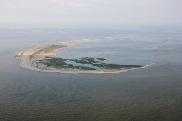
Aerial photograph looking southwest along Breton Island, Louisiana
Aerial photograph looking southwest along Breton Island, Louisiana, taken July 2013
Aerial photograph looking southwest along Breton Island, Louisiana, taken July 2013

Wave-tide gauge off San Juan
Wave-tide gauge, pictured here on a coral reef amongst sea rods, brain corals, and sea fans, installed off Isla Verde in San Juan, Puerto Rico.
Wave-tide gauge, pictured here on a coral reef amongst sea rods, brain corals, and sea fans, installed off Isla Verde in San Juan, Puerto Rico.

USGS researchers ride along the dune; Kennedy Space Center in distance
The USGS collaborates with NASA, the University of Florida, National Park Service, and the U.S. Fish and Wildlife Service to assess coastal erosion hazards affecting space program infrastructure, habitat, and wildlife populations.
The USGS collaborates with NASA, the University of Florida, National Park Service, and the U.S. Fish and Wildlife Service to assess coastal erosion hazards affecting space program infrastructure, habitat, and wildlife populations.

Endicott Island, Alaska
Endicott Island, and artificial island built in 1987 by Alaska Interstate Construction and is used by BP and Hilcorp Alaska for petroleum production.
Endicott Island, and artificial island built in 1987 by Alaska Interstate Construction and is used by BP and Hilcorp Alaska for petroleum production.

Cape Cod hazards
USGS geologists Dave Foster and Wayne Baldwin and Andrew Green (University of
KwaZulu-Natal) observe coastal hazards on the Lower Cape, Massachusetts.
USGS geologists Dave Foster and Wayne Baldwin and Andrew Green (University of
KwaZulu-Natal) observe coastal hazards on the Lower Cape, Massachusetts.

Unalakleet video camera snapshot
Two video cameras overlook the coast from atop a windmill tower in Unalakleet, Alaska where they look westward over Norton Sound. This is a snapshot taken from one of the cameras.
Two video cameras overlook the coast from atop a windmill tower in Unalakleet, Alaska where they look westward over Norton Sound. This is a snapshot taken from one of the cameras.

Imagery of Liberty Island Conservation Bank Wildlands restoration site
Digital Surface Model (DSM) and orthomosaic image from the October 23, 2018 UAS survey.
Digital Surface Model (DSM) and orthomosaic image from the October 23, 2018 UAS survey.

miniSEABOSS deployment off the R/V Petrel
Wayne Baldwin (USGS, far right) with students and staff from Stockton University getting ready to deploy the miniSEABOSS off the R/V Petrel during the geological sampling survey in October 2018.
Wayne Baldwin (USGS, far right) with students and staff from Stockton University getting ready to deploy the miniSEABOSS off the R/V Petrel during the geological sampling survey in October 2018.

Coral cores like this one reveal geologic history of Keys reefs
USGS Research Oceanographer Lauren Toth and Oceanographer Anastasios Stathakopoulos study a coral-reef core in the USGS’s Core Archive in St. Petersburg, Florida. Photo: Dominique Gallery, USGS.
USGS Research Oceanographer Lauren Toth and Oceanographer Anastasios Stathakopoulos study a coral-reef core in the USGS’s Core Archive in St. Petersburg, Florida. Photo: Dominique Gallery, USGS.

Andrea "Andy" O'Neill in Monterey
“The ocean is the closest I can get to an unexplored world, without going into space... I mean, I feel a deep connection to the ocean and its constant rhythms, but when I visit, there's a new discovery or appreciation every time.
“The ocean is the closest I can get to an unexplored world, without going into space... I mean, I feel a deep connection to the ocean and its constant rhythms, but when I visit, there's a new discovery or appreciation every time.

Mapping nearshore depths along a beach
Cordell Johnson uses a personal watercraft (PWC) equipped with GPS and sonar to measure seafloor depths near the beach.
Cordell Johnson uses a personal watercraft (PWC) equipped with GPS and sonar to measure seafloor depths near the beach.

Measuring dune elevations
Dan Nowacki measures dune elevations near the mouth of the Pajaro River with a precision GPS unit carried in his backpack.
Dan Nowacki measures dune elevations near the mouth of the Pajaro River with a precision GPS unit carried in his backpack.

Strong hurricane impacts predicted for many Panhandle beaches
Coastal Change Storm Hazard Team map created Tuesday, 10/89/18 showing current forecasted beach erosion, overwash and inundation effects of Hurricane Michael's predicted landfall in the Florida Panhandle. Forecast will change with subsequent National Hurricane Center forecasts.
Coastal Change Storm Hazard Team map created Tuesday, 10/89/18 showing current forecasted beach erosion, overwash and inundation effects of Hurricane Michael's predicted landfall in the Florida Panhandle. Forecast will change with subsequent National Hurricane Center forecasts.

Backscatter map offshore of Santa Cruz
Between November 2014 and June 2016 the U.S. Geological Survey, Pacific Coastal and Marine Science Center (PCMSC) conducted eight repeat, high-resolution bathymetry and acoustic-backscatter surveys of a small patch of seafloor offshore Santa Cruz in northern Monterey Bay, California.
Between November 2014 and June 2016 the U.S. Geological Survey, Pacific Coastal and Marine Science Center (PCMSC) conducted eight repeat, high-resolution bathymetry and acoustic-backscatter surveys of a small patch of seafloor offshore Santa Cruz in northern Monterey Bay, California.