
Examples of sulfide minerals that occur at hydrothermal vents and are being studied by Amy Gartman: (left to right) sphalerite, an ore of zinc that often contains iron ([Zn,Fe]S); cubes of pyrite, rich in iron (FeS2); and covellite, containing copper and sulfur (CuS).The pyrite cubes are a little more than half an inch on a side.
Images
Images intro.
Filter Total Items: 2135

Sulfide minerals
Examples of sulfide minerals that occur at hydrothermal vents and are being studied by Amy Gartman: (left to right) sphalerite, an ore of zinc that often contains iron ([Zn,Fe]S); cubes of pyrite, rich in iron (FeS2); and covellite, containing copper and sulfur (CuS).The pyrite cubes are a little more than half an inch on a side.

Scientists collect beach elevation data near Moss Landing, California
Left to right: USGS scientist Josh Logan, USGS contractor Babak Tehranirad, and USGS contractor Rae Taylor-Burns (University of California-Santa Cruz graduate student) collect beach elevation data near Moss Landing, California, with precision GPS units carried in their backpacks.
Left to right: USGS scientist Josh Logan, USGS contractor Babak Tehranirad, and USGS contractor Rae Taylor-Burns (University of California-Santa Cruz graduate student) collect beach elevation data near Moss Landing, California, with precision GPS units carried in their backpacks.

Coastal wetland ecosystems in Jamaica Bay, New York,
Coastal wetland ecosystems in Jamaica Bay, New York, provide important ecosystem services along the highly urbanized Atlantic coast.
Coastal wetland ecosystems in Jamaica Bay, New York, provide important ecosystem services along the highly urbanized Atlantic coast.

Sea level rise scenario model for Dauphin Island, Alabama
This model shows what Dauphin Island, Alabama, may look like under moderate storms but with increasing rates of sea level rise (Passeri and others, 2018).
This model shows what Dauphin Island, Alabama, may look like under moderate storms but with increasing rates of sea level rise (Passeri and others, 2018).
Storm and sea level rise scenario model for Dauphin Island, Alabama
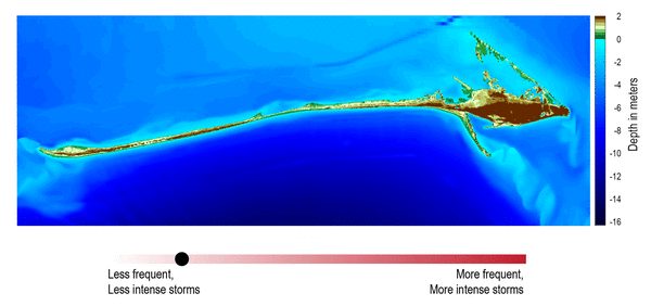
Storm and sea level rise scenario models, like the one shown here, can be used to explore the future. This model shows what Dauphin Island may look like 10 years from now if storms become stronger and more frequent (Passeri and others, 2018).
Storm and sea level rise scenario models, like the one shown here, can be used to explore the future. This model shows what Dauphin Island may look like 10 years from now if storms become stronger and more frequent (Passeri and others, 2018).

Deployment of the chirp seismic instrument from the beach
Most underwater seismic data is collected from large research vessels; however, the shoreface environment is shallower than areas in which most seismic surveys occur. To get the information we need to assess changes in shoreface geology, we mount our seismic instruments on pontoon floats and deploy the instrument from the beach.
Most underwater seismic data is collected from large research vessels; however, the shoreface environment is shallower than areas in which most seismic surveys occur. To get the information we need to assess changes in shoreface geology, we mount our seismic instruments on pontoon floats and deploy the instrument from the beach.

USGS aerial imaging mapping team
USGS unmanned aerial system (uas) mapping team on the beach in Dauphin Island, Alabama
USGS unmanned aerial system (uas) mapping team on the beach in Dauphin Island, Alabama

Perspective lidar view of coastal bathymetry at St. Thomas, USVI
Perspective view of coastal bathymetry looking onshore, St. Thomas, US Virgin Islands, mapped using lidar and depicted with false-color, showing detailed submerged features, including coral reefs.
Perspective view of coastal bathymetry looking onshore, St. Thomas, US Virgin Islands, mapped using lidar and depicted with false-color, showing detailed submerged features, including coral reefs.

PCMSC vessel San Lorenzo
USGS Pacific Coastal and Marine Science Center's research vessel R/V San Lorenzo.
USGS Pacific Coastal and Marine Science Center's research vessel R/V San Lorenzo.

PCMSC vessel San Lorenzo at sunset
Sun sets on Whiskeytown Lake with PCMSC's vessel San Lorenzo in foreground.
Sun sets on Whiskeytown Lake with PCMSC's vessel San Lorenzo in foreground.

Tulum, Mexico jungle panorama
Tulum, Mexico jungle panorama

Ready to dive in Yucatan Peninsula
USGS personnel preparing to dive in Yucatan Peninsula.
USGS personnel preparing to dive in Yucatan Peninsula.

Tulum, Mexico hike through the jungle
Hike through the jungle in Tulum, Mexico
Hike through the jungle in Tulum, Mexico

Collecting water samples in Yucatan Peninsula, Mexico
Collecting water samples in Yucatan Peninsula, Mexico.
Collecting water samples in Yucatan Peninsula, Mexico.

SWATHplus in the water
The SWATHplus is a 234 kHz interferometric bathymetric survey tool for surveys in water depths from 1 to 200 meters.
The SWATHplus is a 234 kHz interferometric bathymetric survey tool for surveys in water depths from 1 to 200 meters.

What the skipper sees
Looking through the windshield of USGS Pacific Coastal and Marine Science Center's boat San Lorenzo under pristine field conditions.
Looking through the windshield of USGS Pacific Coastal and Marine Science Center's boat San Lorenzo under pristine field conditions.

Dr. Christina Kellogg loads coral samples for DNA extraction
SPCMSC Research Microbiologist Christina Kellogg loading coral samples into an automated DNA extraction instrument for processing.
SPCMSC Research Microbiologist Christina Kellogg loading coral samples into an automated DNA extraction instrument for processing.

Dauphin Island, Alabama
A view of a vegetated inland coastline overlooking the water on Dauphin Island, Alabama. The island protects mainland Alabama’s coastal communities and resources from storms, while also providing recreational opportunities (fishing, beach tourism, etc.) and other economic benefits to the local community and state.
A view of a vegetated inland coastline overlooking the water on Dauphin Island, Alabama. The island protects mainland Alabama’s coastal communities and resources from storms, while also providing recreational opportunities (fishing, beach tourism, etc.) and other economic benefits to the local community and state.

Dauphin Island, Alabama
A panoramic view on Dauphin Island, Alabama. The island protects mainland Alabama’s coastal communities and resources from storms, while also providing recreational opportunities (fishing, beach tourism, etc.) and other economic benefits to the local community and state.
A panoramic view on Dauphin Island, Alabama. The island protects mainland Alabama’s coastal communities and resources from storms, while also providing recreational opportunities (fishing, beach tourism, etc.) and other economic benefits to the local community and state.

Herring River, Wellfleet, MA
The Herring River in Wellfleet, MA is a tidally-restricted estuary system. Management options including potential restoration of unrestricted tidal flows require an understanding of pre-restoration sediment conditions
The Herring River in Wellfleet, MA is a tidally-restricted estuary system. Management options including potential restoration of unrestricted tidal flows require an understanding of pre-restoration sediment conditions
Herring River, Wellfleet, MA
The Herring River in Wellfleet, MA is a tidally-restricted estuary system. Management options including potential restoration of unrestricted tidal flows require an understanding of pre-restoration sediment conditions.
The Herring River in Wellfleet, MA is a tidally-restricted estuary system. Management options including potential restoration of unrestricted tidal flows require an understanding of pre-restoration sediment conditions.