
Microbial Biogeochemistry Laboratory — Menlo Park, California. USGS scientist collecting samples of aquatic species from the Pike River, Wis., for later analysis of mercury contamination.
Images
Images intro.
Filter Total Items: 411

Collecting samples of aquatic species from the Pike River, Wisconsin
Microbial Biogeochemistry Laboratory — Menlo Park, California. USGS scientist collecting samples of aquatic species from the Pike River, Wis., for later analysis of mercury contamination.

A saltwater tracer was injected into the shallow aquifer
Hydrogeophysics Laboratory — Storrs, Connecticut. A saltwater tracer was injected into the shallow aquifer at a uranium-contaminated site in Colorado and monitored for 28 days using a combination of geophysical and well-sampling arrays; the sampling array is marked by the white standpipes adjacent to the central injection tank.
Hydrogeophysics Laboratory — Storrs, Connecticut. A saltwater tracer was injected into the shallow aquifer at a uranium-contaminated site in Colorado and monitored for 28 days using a combination of geophysical and well-sampling arrays; the sampling array is marked by the white standpipes adjacent to the central injection tank.

Schematic diagram of fish affected by oil and gas activities
Diagram showing antrhopods, fish, and other aquatic life in the area of an oil and gas spill.
Diagram showing antrhopods, fish, and other aquatic life in the area of an oil and gas spill.

Filtration system used for processing samples
Filtration system used for processing samples using a technique called polymerase chain reaction (PCR) or quantitative PCR (qPCR).
Filtration system used for processing samples using a technique called polymerase chain reaction (PCR) or quantitative PCR (qPCR).

USGS Scientist Preparing Samples in a Laboratory
U.S. Geological Survey (USGS) scientist preparing samples for analysis of protein levels to normalize results from oxidative stress bioassays.
U.S. Geological Survey (USGS) scientist preparing samples for analysis of protein levels to normalize results from oxidative stress bioassays.

Scenic landscape from Hells Canyon Reservoir, Idaho
Scenic landscape from Hells Canyon Reservoir, Idaho
Scenic landscape from Hells Canyon Reservoir, Idaho

Colonies of the Bacteria Bacillus Globigii on a Petri Dish
Scientists optimized existing methods to collect and identify microorganisms including Bacillus anthracis, a pathogenic microorganism, in 4,800 soil samples across the United States, and developed a
Scientists optimized existing methods to collect and identify microorganisms including Bacillus anthracis, a pathogenic microorganism, in 4,800 soil samples across the United States, and developed a

Microscopic video imaging is used for computerized analysis of sperm m
Photomicroscopy and Flow Cytometry Laboratory — Lafayette, Louisiana. Microscopic video imaging is used for computerized analysis of sperm motility parameters
Photomicroscopy and Flow Cytometry Laboratory — Lafayette, Louisiana. Microscopic video imaging is used for computerized analysis of sperm motility parameters

A U.S. Geological Survey (USGS) microbiologist prepares a water sample
Michigan Bacteriological Research Laboratory — Lansing, Michigan. A microbiologist preparing a water sample
Michigan Bacteriological Research Laboratory — Lansing, Michigan. A microbiologist preparing a water sample

Lake Erie algal bloom
Landsat satellites captured this image of Lake Erie during a harmful algal bloom event.
Landsat satellites captured this image of Lake Erie during a harmful algal bloom event.

Dr. Bethany K. Kunz Sets up a Mobile-Mounted Dust Meter
Dr. Bethany K. Kunz sets up a mobile-mounted dust meter, which measures concentrations of particulate matter across a range of particle sizes. She and her team use the meter to determine the effectiveness of dust control treatments on roads and estimate human exposure to dust in the inhalable size range.
Dr. Bethany K. Kunz sets up a mobile-mounted dust meter, which measures concentrations of particulate matter across a range of particle sizes. She and her team use the meter to determine the effectiveness of dust control treatments on roads and estimate human exposure to dust in the inhalable size range.

Sampling pore water from canoe downgradient of Bemidji oil spill
Four USGS scientists sampling pore water from a canoe in un-named lake approximately 340 meters downgradient of the Bemidji, Minnesota crude oil spill site.
Four USGS scientists sampling pore water from a canoe in un-named lake approximately 340 meters downgradient of the Bemidji, Minnesota crude oil spill site.

Hydrologists doing field work near Farmington, NM
USGS NMWSC Hydrologists Johanna Blake and Jeb Brown attended the 2nd Annual Conference on Environmental Conditions of the Animas and San Juan Watersheds with Emphasis on Gold King Mine and other Mine Waste Issues in Farmington, NM from June 20-21.
USGS NMWSC Hydrologists Johanna Blake and Jeb Brown attended the 2nd Annual Conference on Environmental Conditions of the Animas and San Juan Watersheds with Emphasis on Gold King Mine and other Mine Waste Issues in Farmington, NM from June 20-21.

One of 21 Stormwater Outfalls Sampled
Inside a debris cage, which is used to prevent pipe blockages, at one of 21 stormwater outfalls that was sampled prior to discharge to streams or stormwater ponds.
Inside a debris cage, which is used to prevent pipe blockages, at one of 21 stormwater outfalls that was sampled prior to discharge to streams or stormwater ponds.

This Pond Receives Stormwater Runoff from a Residential Landscape
A stormwater pond that receives runoff from a residential landscape. U.S. Geological Survey scientists analyzed samples of stormwater runoff collected during 2016 and 2017 at 21 sites for 438 organic chemicals and 62 inorganic elements.
A stormwater pond that receives runoff from a residential landscape. U.S. Geological Survey scientists analyzed samples of stormwater runoff collected during 2016 and 2017 at 21 sites for 438 organic chemicals and 62 inorganic elements.

Willow Spring in Hack Canyon in Arizona north of the Grand Canyon
Willow Spring in Hack Canyon in Arizona north of the Grand Canyon. A sign next to the spring says Water Not Suitable for Drinking. The spring has elevated levels of uranium and selenium. The elevated uranium level is most likely not associated with breccia-pipe uranium mining in the area.
Willow Spring in Hack Canyon in Arizona north of the Grand Canyon. A sign next to the spring says Water Not Suitable for Drinking. The spring has elevated levels of uranium and selenium. The elevated uranium level is most likely not associated with breccia-pipe uranium mining in the area.

Iowa River at Iowa City
Iowa River at Iowa City
Iowa River at Iowa City

Scientist preparing for granular activated carbon experiments
Scientist preparing for granular activated carbon experiments
Scientist preparing for granular activated carbon experiments
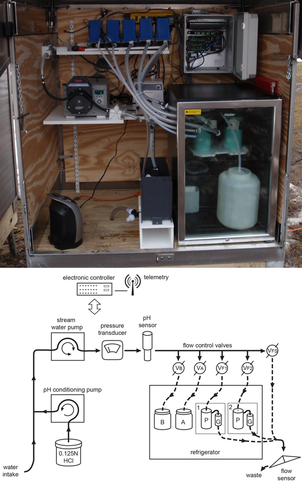
A custom automated pathogen sampler and schematic illustration.
A photograph of U.S. Geological Survey (USGS) custom automated pathogen sampler (top) and schematic illustrating the remote-unattended-automated pathogen sampler (bottom). Sample collection proceeds over the course of a runoff-event or low-flow period for up to a maximum of 5 days before a site visit by personnel is needed to collect the samples.
A photograph of U.S. Geological Survey (USGS) custom automated pathogen sampler (top) and schematic illustrating the remote-unattended-automated pathogen sampler (bottom). Sample collection proceeds over the course of a runoff-event or low-flow period for up to a maximum of 5 days before a site visit by personnel is needed to collect the samples.

Buras water tank, eye of Hurricane Katrina made its strongest landfall
New Orleans, La., July 29, 2008 -- Buras has become famous as the location where, on August 29, 2005, at 6:10 AM CDT, the eye of Hurricane Katrina, made its strongest landfall. The town's freshing painted water tower stands as a symbol of recovery for the state and the community. Jacinta Quesada/FEMA
New Orleans, La., July 29, 2008 -- Buras has become famous as the location where, on August 29, 2005, at 6:10 AM CDT, the eye of Hurricane Katrina, made its strongest landfall. The town's freshing painted water tower stands as a symbol of recovery for the state and the community. Jacinta Quesada/FEMA

Cumulative impacts of oil and gas production on watersheds in ND
Cumulative impacts of oil and gas production on watersheds in North Dakota between January 2008 and June 2015. Watershed volumes were calculated by combining reported values of oil, brine, and unidentified liquid waste accidentally released during drilling operations.
Cumulative impacts of oil and gas production on watersheds in North Dakota between January 2008 and June 2015. Watershed volumes were calculated by combining reported values of oil, brine, and unidentified liquid waste accidentally released during drilling operations.