
Continuous stage only gaging station located at Mystic River at Rt. 1 bridge, Connecticut (USGS Site ID 412117071580800)
Images
Images
Filter Total Items: 1910

Continuous stage only gaging station
Continuous stage only gaging station located at Mystic River at Rt. 1 bridge, Connecticut (USGS Site ID 412117071580800)

Field sampling at Sheboygan WI, April 2021
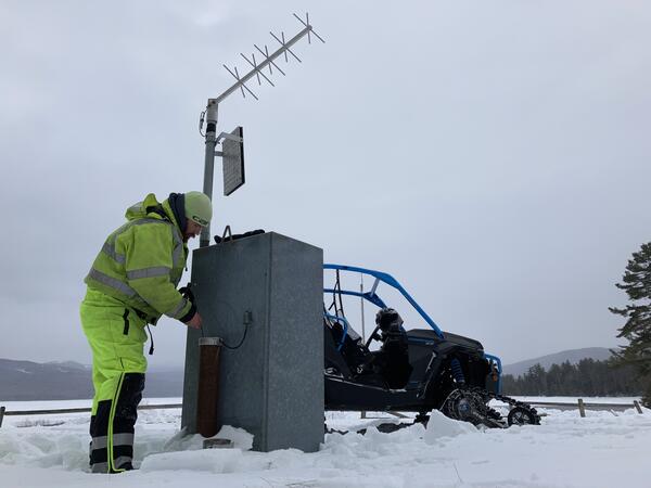
The Region 1, May 2021 "People" Winner (by Heather Walsh)
The Region 1, May 2021 "People" Winner (by Heather Walsh)

Tidal monitoring gage
Tidal monitoring gage on a drawbridge over the Mystic River in Mystic, Connecticut.
Tidal monitoring gage on a drawbridge over the Mystic River in Mystic, Connecticut.

Shelton Produced Water Field Sampling
The Region 1, April 2021 "Honorable Mention #2" Winner (by Bonnie McDevitt)
The Region 1, April 2021 "Honorable Mention #2" Winner (by Bonnie McDevitt)

Mooring Recovery in Cape Cod Bay, MA
The Region 1, April 2021 "USGS at Work" Winner (by Alex Olson)
The Region 1, April 2021 "USGS at Work" Winner (by Alex Olson)

Burlington Falls on Bunnell Brook
Studying the mountain streams and rivers of New England means never being too far from a scenic and historic waterfall, like the Burlington Falls on Bunnell Brook pictured here. This natural resource attracted small industries to a mostly rural Burlington, CT in the early-19th century.
Studying the mountain streams and rivers of New England means never being too far from a scenic and historic waterfall, like the Burlington Falls on Bunnell Brook pictured here. This natural resource attracted small industries to a mostly rural Burlington, CT in the early-19th century.

Gainer Memorial Dam, Scituate Reservoir, Rhode Island
The north side of the Gainer Memorial Dam, Scituate Reservoir, Rhode Island.
The north side of the Gainer Memorial Dam, Scituate Reservoir, Rhode Island.

Gainer Memorial Dam, Rhode Island
The south side of the Gainer Memorial Dam, Scituate Reservoir, Rhode Island. The reservoir began storing water on November 10, 1925.
The south side of the Gainer Memorial Dam, Scituate Reservoir, Rhode Island. The reservoir began storing water on November 10, 1925.

Latimer Brook High Flow
A long exposure shot shows the flow and direction of water through the gage pool during a high-flow event in April 2021. Looking upstream you can see the staff plate and a felled tree which is not impacting flow.
A long exposure shot shows the flow and direction of water through the gage pool during a high-flow event in April 2021. Looking upstream you can see the staff plate and a felled tree which is not impacting flow.

Woods Hole Sediment Analysis Lab's Beckman Coulter Multisizer 3
Woods Hole Coastal and Marine Science Center Sediment Analysis Laboratory's Beckman Coulter Multisizer 3 (USGS laboratory equipment number WH-SED-BeckmanCoulter-Multisizer1).
Woods Hole Coastal and Marine Science Center Sediment Analysis Laboratory's Beckman Coulter Multisizer 3 (USGS laboratory equipment number WH-SED-BeckmanCoulter-Multisizer1).

Woods Hole Sediment Analysis Lab's Rigaku Miniflex 600
Woods Hole Coastal and Marine Science Center Sediment Analysis Laboratory's Rigaku Miniflex 600 (USGS laboratory equipment number WH-SED-Rigaku-Miniflex1).
Woods Hole Coastal and Marine Science Center Sediment Analysis Laboratory's Rigaku Miniflex 600 (USGS laboratory equipment number WH-SED-Rigaku-Miniflex1).

Aerial photo of Cold River in Maine
Photo Contest Winner | March 2021 | Where We Work
Aerial photo of Cold River in Maine
Photo Contest Winner | March 2021 | Where We Work
Aerial photo of Cold River in Maine
Winter Groundwater Comparisons at Middle Dam, Maine
Hydrologic technician making groundwater measurements and inspecting the USGS groundwater site monitoring equipment.
Hydrologic technician making groundwater measurements and inspecting the USGS groundwater site monitoring equipment.

Collecting an isokinetic equal-width increment water sample
Photograph of U.S. Geological Survey technician collecting an isokinetic equal-width increment water sample at USGS streamgage 01115265, Hemlock Brook at King Road near Foster, Rhode Island.
Photograph of U.S. Geological Survey technician collecting an isokinetic equal-width increment water sample at USGS streamgage 01115265, Hemlock Brook at King Road near Foster, Rhode Island.

Precipitation measurement and sampling at a meteorological platform
The photo shows a Belfort Weighing Bucket, Tipping Bucket, Aerochem, Ott Pluvio , Hubbard Brook, and standard rain gage. Sleepers River Research Watershed, Danville, Vermont.
The photo shows a Belfort Weighing Bucket, Tipping Bucket, Aerochem, Ott Pluvio , Hubbard Brook, and standard rain gage. Sleepers River Research Watershed, Danville, Vermont.

Flatrock River at St. Paul, IN
Photo Contest Winner | March 2021 | Honorable Mention
03363500 Flatrock River at St. Paul, IN; established 1930
Photo Contest Winner | March 2021 | Honorable Mention
03363500 Flatrock River at St. Paul, IN; established 1930

USGS employees on boat
Photo Contest Winner | March 2021 | People
USGS employees on boat
Photo Contest Winner | March 2021 | People
USGS employees on boat

GEMSC supply distribution day
Photo Contest Winner | March 2021 | USGS at Work
GEMSC supply distribution day
Photo Contest Winner | March 2021 | USGS at Work
GEMSC supply distribution day

Frost tube
Photo of a recently retrieved frost tube during the Snow Depth and Snow Water Equivalent (SWE) measurement. Sleepers River Research Watershed, Danville, Vermont.
Photo of a recently retrieved frost tube during the Snow Depth and Snow Water Equivalent (SWE) measurement. Sleepers River Research Watershed, Danville, Vermont.

Chesapeake Bay Watershed boundary, USA
The Chesapeake Bay watershed, or draingage basin, encompasses six states - New York, Pennsylvania, West Virginia, Maryland, Delaware, Virginia, and the District of Columbia. A drainage basin is a giant system of creeks, streams, and rivers that all flow into a common outlet, which in this case is the Chesapeake Bay.
The Chesapeake Bay watershed, or draingage basin, encompasses six states - New York, Pennsylvania, West Virginia, Maryland, Delaware, Virginia, and the District of Columbia. A drainage basin is a giant system of creeks, streams, and rivers that all flow into a common outlet, which in this case is the Chesapeake Bay.
