
Photo Contest Winner | August 2021 | Where We Work
Hoosick River near Williamstown, MA sculpture
Images
Images
Filter Total Items: 1910

Hoosick River near Williamstown, MA sculpture
Photo Contest Winner | August 2021 | Where We Work
Hoosick River near Williamstown, MA sculpture

Field sampling crew with favorite equipment
Photo Contest Winner | August 2021 | People
Field sampling crew with favorite equipment
Photo Contest Winner | August 2021 | People
Field sampling crew with favorite equipment

Impounded wetland eddy flux tower install
Photo Contest Winner | August 2021 | USGS at Work
Impounded wetland eddy flux tower install
Photo Contest Winner | August 2021 | USGS at Work
Impounded wetland eddy flux tower install

Chany Huddleston and Ross Clyma prepare QBoat at Schoharie Creek
Photo Contest Winner | September 2021 | Where We Work
Chany Huddleston and Ross Clyma prepare QBoat at Schoharie Creek
Photo Contest Winner | September 2021 | Where We Work
Chany Huddleston and Ross Clyma prepare QBoat at Schoharie Creek

Nick Grim and Cameron Ensor rescuing a goose
Photo Contest Winner | August 2021 | Honorable Mention 2
Nick Grim and Cameron Ensor rescuing a goose that got stuck in fishing line on the Delaware River
Photo Contest Winner | August 2021 | Honorable Mention 2
Nick Grim and Cameron Ensor rescuing a goose that got stuck in fishing line on the Delaware River

5000th Sample Collected on Stellwagen Bank
Page Valentine, USGS Research Geologist, collects his 5000th sample on Stellwagen Bank National Marine Sanctuary. Page has been mapping the geologic substrates of Stellwagen
Page Valentine, USGS Research Geologist, collects his 5000th sample on Stellwagen Bank National Marine Sanctuary. Page has been mapping the geologic substrates of Stellwagen

Celebrating 50000 samples collected on Stellwagen Bank
Celebrating Page Valentine's 5000th sample collected on Stellwagen Bank National Marine Sanctuary. Page Valentine, USGS Research Geologist, collects his 5000th sample on Stellwagen Ba
Celebrating Page Valentine's 5000th sample collected on Stellwagen Bank National Marine Sanctuary. Page Valentine, USGS Research Geologist, collects his 5000th sample on Stellwagen Ba

Sampling the Paleocene Aquia Formation, Prince George’s County, Maryland
USGS Scientist Emeritus David Govoni sampling the Paleocene Aquia Formation, Prince George’s County, Maryland
USGS Scientist Emeritus David Govoni sampling the Paleocene Aquia Formation, Prince George’s County, Maryland

Indurated bed of the Paleocene Aquia Formation, Prince George’s County, Maryland
USGS Scientist Laurel Bybell standing on an indurated bed of the Paleocene Aquia Formation with a thick layer of highly fossilferous Aquia sediment above, Prince George’s County, Maryland
USGS Scientist Laurel Bybell standing on an indurated bed of the Paleocene Aquia Formation with a thick layer of highly fossilferous Aquia sediment above, Prince George’s County, Maryland
Geologists measuring and sampling the Paleocene Aquia Formation, Prince George’s County, Maryland
linkUSGS geologists Jean Self-Trail and Mercer Parker measuring and sampling the Paleocene Aquia Formation, Prince George’s County, Maryland
Geologists measuring and sampling the Paleocene Aquia Formation, Prince George’s County, Maryland
linkUSGS geologists Jean Self-Trail and Mercer Parker measuring and sampling the Paleocene Aquia Formation, Prince George’s County, Maryland

Aquia Formation (Paleocene) shell hash, Prince George’s County, Maryland
A typical Aquia Formation shell hash consisting mainly of the Paleocene gastropod Kapalmerella mortoni, Prince George’s County, Maryland
A typical Aquia Formation shell hash consisting mainly of the Paleocene gastropod Kapalmerella mortoni, Prince George’s County, Maryland

Yaquina Bay, Newport, Oregon
Marcus G. Langseth departs Newport, Oregon (Yaquina Bay) for Cascadia Project OBS Deployment Leg
Marcus G. Langseth departs Newport, Oregon (Yaquina Bay) for Cascadia Project OBS Deployment Leg


Aquia Formation (Paleocene), Prince George’s County, Maryland
General view of an outcrop of the fossiliferous Paleocene Aquia Formation, Prince George’s County, Maryland
General view of an outcrop of the fossiliferous Paleocene Aquia Formation, Prince George’s County, Maryland

Taking a water sample in Green River
Photo Contest Winner | July 2021 | Honorable Mention 1
Taking a water sample in Green River
Photo Contest Winner | July 2021 | Honorable Mention 1
Taking a water sample in Green River

Paper mill reservoir in the Black River Valley
Photo Contest Winner | July 2021 | Where We Work
Paper mill reservoir in the Black River Valley, western Adirondacks, near Lyonsdale, New York
Photo Contest Winner | July 2021 | Where We Work
Paper mill reservoir in the Black River Valley, western Adirondacks, near Lyonsdale, New York

Mark Jones taking a measurement in Danville, Pennsylvania
Photo Contest Winner | July 2021 | Honorable Mention 2
Mark Jones taking a measurement in Danville, Pennsylvania
Photo Contest Winner | July 2021 | Honorable Mention 2
Mark Jones taking a measurement in Danville, Pennsylvania

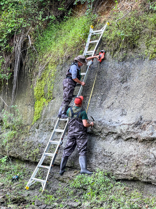
Jean Self-Trail and Laurel Bybell in Prince Georges County, Maryland
Photo Contest Winner | July 2021 | People
Jean Self-Trail and Laurel Bybell in Prince Georges County, Maryland
Photo Contest Winner | July 2021 | People
Jean Self-Trail and Laurel Bybell in Prince Georges County, Maryland

Cameron Ensor and Nick Grim demolish a broad-crested weir
Photo Contest Winner | July 2021 | USGS at Work
Certified USGS Heavy Equipment Operators Cameron Ensor and Nick Grim demolish a broad-crested weir at USGS Station 01574500 at Cordorus Creek in Spring Grove, PA
Photo Contest Winner | July 2021 | USGS at Work
Certified USGS Heavy Equipment Operators Cameron Ensor and Nick Grim demolish a broad-crested weir at USGS Station 01574500 at Cordorus Creek in Spring Grove, PA

Kennebec River at The Forks
The view from the river of the USGS gaging station on the Kennebec River at The Forks, station 01042500 during summer.
The view from the river of the USGS gaging station on the Kennebec River at The Forks, station 01042500 during summer.