
The Park Fire north of Sacramento in California forced thousands of residents to evacuate in late July as it spread to over 370,000 acres. The fire started on July 24th. Landsat 8 captured an image of the fire two days later.
Landsat 9
Landsat 9 Data Products
Level-1, Level-2, U.S. and Level-3 Products Available
Level-1, Level-2, U.S. and Level-3 Products Available
Landsat 9 is a partnership between the U.S. Geological Survey (USGS) and the National Aeronautics and Space Administration (NASA) and continues the Landsat program’s critical role of repeat global observations for monitoring, understanding, and managing Earth’s natural resources.
Road to Launch
Road to Launch

Visit this interactive StoryMap to learn more about the process of building Landsat 9 and how it will extend Landsat’s unbroken record of our planet to over a half a century.
Fact sheet
Fact sheet

For an overview of the Landsat 9 mission, download the fact sheet from the USGS Publications Warehouse.
Transition to Operations
Transition to Operations

Learn more about the Landsat 9 Commissioning and Operations Phases after Launch
Media

Sources/Usage: Public Domain. View Media Details
Since 1972, Landsat data provide a unique resource for those who work in agriculture, geology, forestry, regional planning, education, mapping, and global change research. Landsat images also prove invaluable to the International Charter: Space and Major Disasters, supporting emergency response and disaster relief to save lives. With the addition of Landsat 9, the Landsat program’s record of land imaging extends to over half a century.
Landsat 9 captured five first light images: the Himalayas of Nepal, the Navajo Nation in the Western United States, the inlets of the Kimberly region of Western Australia, the Pensacola Beach on the Florida Panhandle, and the Lake Erie near Detroit, Michigan and Ontario, Canada.
Spacecraft and Launch Components
- Spacecraft Provider: Northrop Grumman
- Spacecraft Bus: Northrop Grumman Innovation Systems (formerly Orbital ATK)
- Launch Vehicle: United Launch Alliance Atlas V 401
- Spacecraft Speed: 16,760 miles/hr (26,972 km/hr)
- Design Life: 5 years
- Consumables: 10 years
Landsat 9 was launched on September 27, 2021 at 1:12PM CST from Vandenberg Space Force Base in California onboard a United Launch Alliance Atlas V 401 rocket. Landsat 9 carries the Operational Land Imager 2 (OLI–2), built by Ball Aerospace & Technologies Corporation, Boulder, Colorado, and the Thermal Infrared Sensor 2 (TIRS–2), built at the NASA Goddard Space Flight Center, Greenbelt, Maryland. Northrop Grumman designed and fabricated the spacecraft and integrated the two instruments.
NASA is responsible for the space segment (instruments and spacecraft/observatory), mission integration, launch, and on-orbit checkout.
After NASA completes on-orbit checkout, the USGS is responsible for the ground system, flight operations, data processing, data product distribution and archiving.
Landsat 9 Instruments
Media

Sources/Usage: Public Domain. View Media Details
The instruments onboard Landsat 9 are improved replicas of those currently collecting data onboard Landsat 8, which are already providing data that is radiometrically and geometrically superior than instruments on previous generation Landsat satellites.
The satellite carries two science instruments, the Operational Land Imager 2 (OLI-2) and the Thermal Infrared Sensor 2 (TIRS-2). The OLI–2 captures observations of the Earth’s surface in visible, near-infrared, and shortwave-infrared bands, and TIRS-2 measures thermal infrared radiation, or heat, emitted from the Earth’s surface. Both OLI and TIRS have a 5-year mission design life, although the spacecraft has 10+ years of consumables.
Landsat 9 improvements include higher radiometric resolution for OLI-2 (14-bit quantization increased from 12-bits for Landsat 8) allowing sensors to detect more subtle differences, especially over darker areas such as water or dense forests. With the higher radiometric resolution, Landsat 9 can differentiate 16,384 shades of a given wavelength. In comparison, Landsat 8 provides 12-bit data and 4,096 shades, and Landsat 7 detects only 256 shades with its 8-bit resolution. In addition to the OLI-2 improvement, TIRS-2 has significantly reduced stray light compared to the Landsat 8 Thermal Infrared Sensor (TIRS) which enables improved atmospheric correction and more accurate surface temperature measurements..
Operational Land Imager 2 (OLI-2)
The OLI-2 design is a copy of Landsat 8’s OLI, and provides imagery consistent with previous Landsat spectral, spatial, radiometric and geometric qualities. OLI-2 will provide data for nine spectral bands with a maximum ground sampling distance (GSD), both in-track and cross track, of 30-meters(m) (98 feet) for all bands except the panchromatic band, which has a 15-meter (49 feet) GSD. OLI-2 provides both internal calibration sources to ensure radiometric accuracy and stability, as well as the ability to perform solar and lunar calibrations. OLI-2 is designed by Ball Aerospace in Boulder, Colorado.
Nine spectral bands:
- Band 1 Visible Coastal Aerosol (0.43 - 0.45 µm) 30-m
- Band 2 Visible Blue (0.450 - 0.51 µm) 30-m
- Band 3 Visible Green (0.53 - 0.59 µm) 30-m
- Band 4 Red (0.64 - 0.67 µm) 30-m
- Band 5 Near-Infrared (0.85 - 0.88 µm) 30-m
- Band 6 SWIR 1(1.57 - 1.65 µm) 30-m
- Band 7 SWIR 2 (2.11 - 2.29 µm) 30-m
- Band 8 Panchromatic (PAN) (0.50 - 0.68 µm) 15-m
- Band 9 Cirrus (1.36 - 1.38 µm) 30-m
Thermal Infrared Sensor 2 (TIRS-2)
Landsat 9’s Thermal Infrared Sensor 2 (TIRS-2) measures thermal radiance emitted from the land surface in two thermal infrared bands using the same technology that was used for TIRS on Landsat 8, however TIRS-2 is an improved version of Landsat 8’s TIRS, both with regards to instrument risk class and design to minimize stray light. TIRS-2 provides two spectral bands with a maximum ground sampling distance, both in-track and cross track, of 100 m (328 ft) for both bands. TIRS-2 provides an internal blackbody calibration source as well as space view capabilities. TIRS-2 is designed by NASA Goddard Space Flight Center in Greenbelt, Maryland.
Two spectral bands:
- Band 10 TIRS 1 (10.6 - 11.19 µm) 100-m
- Band 11 TIRS 2 (11.5 - 12.51 µm) 100-m
Media
Sources/Usage: Public Domain. View Media Details
Landsat 9 Data Products
Data acquired by Landsat 9 is processed into the Landsat Collection 2 inventory structure in the Worldwide Reference System-2 (WRS-2) path/row system, with swath overlap (or sidelap) varying from 7 percent at the Equator to a maximum of approximately 85 percent at extreme latitudes.
Landsat 9 collects as many as 750 scenes per day, and with Landsat 8, the two satellites add nearly 1,500 new scenes a day to the USGS Landsat archive. Landsat 9 increases the volume of the USGS archive by imaging all global landmasses and nearshore coastal regions, including islands at solar elevation angles greater than 5 degrees that were not always routinely collected prior to Landsat 8.
All Landsat 9 data and products are available for download through the USGS Earth Resources Observation and Science (EROS) Center at no charge.
Papers about Landsat 9's Pre-launch, Commissioning, and Early On-Orbit Imaging Performance Published in Science Journal
A new Remote Sensing Special Issue contains information on the calibration and validation activities performed on Landsat 9 instruments to ensure the gold standard of geometric, radiometric, spatial, and spectral resolutions are upheld for delivering the expected data quality. Topics in the special issue include pre-launch characterization, testing, commissioning, and early on-orbit performance for the OLI and TIRS instrument and Landsat 9 spacecraft. Visit the Remote Sensing webpage to access the papers in this issue.
Landsat 9 Documentation and Information
- Landsat 9 Data Users Handbook
- Landsat Project Documentation
- Landsat 9 Information (NASA Landsat Science)
Related
Landsat 9 First Light Image
Landsat 9 First Light Image
Landsat 9 Storymap
Landsat 9 Storymap
Launch Week Gallery
Launch Week Gallery
Filter Total Items: 33

Landsat Images of the Park Fire, July 2024
The Park Fire north of Sacramento in California forced thousands of residents to evacuate in late July as it spread to over 370,000 acres. The fire started on July 24th. Landsat 8 captured an image of the fire two days later.

Landsat 9 Image of Phoenix Metropolitan Area
The Phoenix, Arizona metropolitan area, also known as the Valley of the Sun, is comprised of more than 14,600 square miles and is considered the largest metropolitan area in the southwestern United States. The desert climate and abundant sunshine of the area are main factors in population growth and urban sprawl.
The Phoenix, Arizona metropolitan area, also known as the Valley of the Sun, is comprised of more than 14,600 square miles and is considered the largest metropolitan area in the southwestern United States. The desert climate and abundant sunshine of the area are main factors in population growth and urban sprawl.

Railroad Valley Playa
The Railroad Valley Playa, located in east central Nevada, measures about 80 miles long and nearly 20 miles wide, and is a vast and wide-open landscape.
The Railroad Valley Playa, located in east central Nevada, measures about 80 miles long and nearly 20 miles wide, and is a vast and wide-open landscape.

Landsat 9 Image of White Sands National Park
The Operational Land Imager (OLI) onboard the Landsat 9 satellite captured this image of the White Sands National Park on May 13, 2024.
The Operational Land Imager (OLI) onboard the Landsat 9 satellite captured this image of the White Sands National Park on May 13, 2024.

Landsat 9 Image Captures Iceland Volcano Lava
In November 2023 the Svartsengi volcanic system awakened after almost 800 years with a series of earthquakes that opened large cracks in the on Iceland’s Reykjanes Peninsula. An eruption on December 18th spewed lava away from the nearby coastal town of Grindavik, but the January 14, 2024 eruption sent lava directly toward the town.
In November 2023 the Svartsengi volcanic system awakened after almost 800 years with a series of earthquakes that opened large cracks in the on Iceland’s Reykjanes Peninsula. An eruption on December 18th spewed lava away from the nearby coastal town of Grindavik, but the January 14, 2024 eruption sent lava directly toward the town.

Spectral Bandpasses for all Landsat Sensors
This image shows the spectral bandpasses for the sensors on all Landsat satellites.
This image shows the spectral bandpasses for the sensors on all Landsat satellites.

Landsat 9 image of San Francisco Bay Area captured October 29, 2023
A Landsat 9 satellite image of the San Francisco Bay Area captured on October 29, 2023.
A Landsat 9 satellite image of the San Francisco Bay Area captured on October 29, 2023.

Landsat 9 image of the White Mountain National Forest, New Hampshire
Natural color image of the White Mountain National Forest, New Hampshire, as seen by Landsat 9 on October 4th, 2023.
WRS-2 Path 013 Row 029.
Bands 4,3,2
Landsat Scene ID LC09_L2SP_013029_20231004_20231005_02_T1
Natural color image of the White Mountain National Forest, New Hampshire, as seen by Landsat 9 on October 4th, 2023.
WRS-2 Path 013 Row 029.
Bands 4,3,2
Landsat Scene ID LC09_L2SP_013029_20231004_20231005_02_T1

Landsat 9 image of Lake Sunapee in 2023
An example of a Landsat 9 image of the Lake Sunapee, New Hampshire April 13th, 2023. Path:013/Row: 30. Natural Color (4,3,2).
Visit the Landsat Missions Web Site to learn more about Landsat missions and products.
An example of a Landsat 9 image of the Lake Sunapee, New Hampshire April 13th, 2023. Path:013/Row: 30. Natural Color (4,3,2).
Visit the Landsat Missions Web Site to learn more about Landsat missions and products.

Trio of Landsat Satellites Capture Alberta Fires May 2023
The three active Landsat satellites captured imagery of fires burning in an area of the Alberta province, Canada, in May of 2023.
This animation displays mosaics of the imagery acquired by Landsat 9’s Operational Land Imager (OLI) on May 13th, Landsat 8’s OLI on May 14th, and Landsat 7’s Enhanced Thematic Mapper Plus (ETM+) on May 16th.

Landsat 9 Image of Shiveluch Volcano
Found along the Pacific Ring of Fire, Russia’s Shiveluch Volcano began erupting on April 11, 2023. Huge ash clouds spewed from the main crater blanketing over 40,000 square miles (108,000 square kilometers). The tiny village of Klyuchi, about 30 mi (50 km) from the volcano, plunged into darkness.
Found along the Pacific Ring of Fire, Russia’s Shiveluch Volcano began erupting on April 11, 2023. Huge ash clouds spewed from the main crater blanketing over 40,000 square miles (108,000 square kilometers). The tiny village of Klyuchi, about 30 mi (50 km) from the volcano, plunged into darkness.

Landsat 9 Image of Washington D.C.
Landsat 9 image showing Washington D.C. on April 9, 2023. The image is shown using the Red, Green and Blue bands (Bands 4,3,2), combining these three bands produces a natural color view of the area. The image was then sharpened using the panchromatic band (Band 8) which has a higher resolution than the other bands (15 meters compared to 30 meters).
Landsat 9 image showing Washington D.C. on April 9, 2023. The image is shown using the Red, Green and Blue bands (Bands 4,3,2), combining these three bands produces a natural color view of the area. The image was then sharpened using the panchromatic band (Band 8) which has a higher resolution than the other bands (15 meters compared to 30 meters).

Landsat 9 Image of Sacramento Valley on December 13, 2022
This natural color Landsat 9 image (Bands 4|3|2) was acquired on December 13, 2022 and shows the Sacramento Valley and surrounding area.
This natural color Landsat 9 image (Bands 4|3|2) was acquired on December 13, 2022 and shows the Sacramento Valley and surrounding area.

Landsat 9 image of Hurricane Ian with Cuba
Landsat 9 image of Hurricane Ian as the eye of the storm passed north of Cuba on the morning of Tuesday, September 27, 2022. The image has the island boundary overlaid on it. Image credit: USGS EROS
Landsat 9 image of Hurricane Ian as the eye of the storm passed north of Cuba on the morning of Tuesday, September 27, 2022. The image has the island boundary overlaid on it. Image credit: USGS EROS

Landsat 9 Image of Kangerdlugssuaq Glacier, Greenland
Named after a Greenlandic word meaning “large fjord,” Kangerdlugssuaq Glacier is one of the largest tidewater outlet glaciers in Greenland. It flows from the fjord of the same name, the second largest found on the east side of the island. This false color Landsat 9 image was acquired July 29, 2022, using Bands 5|4|3.
Named after a Greenlandic word meaning “large fjord,” Kangerdlugssuaq Glacier is one of the largest tidewater outlet glaciers in Greenland. It flows from the fjord of the same name, the second largest found on the east side of the island. This false color Landsat 9 image was acquired July 29, 2022, using Bands 5|4|3.

Landsat 9 Image of Aorounga Crater
The Aorounga Crater located in Chad, Africa is a large impact crater that appears as a circular depression surrounded by a raised rim, as seen in this Landsat 9 image. The crater is surrounded by a vast expanse of desert and is known for its unique rock ridges, known as yardangs.
The Aorounga Crater located in Chad, Africa is a large impact crater that appears as a circular depression surrounded by a raised rim, as seen in this Landsat 9 image. The crater is surrounded by a vast expanse of desert and is known for its unique rock ridges, known as yardangs.

Landsat 9 image of the Dallas - Fort Worth Area
This Landsat 9 image, showing the Dallas - Fort Worth area of Texas, was acquired on July 15, 2022. This false-color image vegetated land in shades of red, whereas grays and whites indicate urban or rocky surfaces.
This Landsat 9 image, showing the Dallas - Fort Worth area of Texas, was acquired on July 15, 2022. This false-color image vegetated land in shades of red, whereas grays and whites indicate urban or rocky surfaces.

Landsat 9 image over Svalbard, Norway
Landsat 9 image over Svalbard, Norway. Acquired on July 8, 2022, Path 26 Row 240. For more information on Landsat data, visit the Landsat Mission Website.
Landsat 9 image over Svalbard, Norway. Acquired on July 8, 2022, Path 26 Row 240. For more information on Landsat data, visit the Landsat Mission Website.

Landsat 9 Image of Washburn Fire, Yosemite National Park - July 7, 2022
The Washburn Fire started July 7, 2022 in the southern part of Yosemite National Park. Landsats 8 and 9 both captured imagery of it a day later. The Landsat 9 image uses shortwave infrared and near-infrared bands to show the active burning.
The Washburn Fire started July 7, 2022 in the southern part of Yosemite National Park. Landsats 8 and 9 both captured imagery of it a day later. The Landsat 9 image uses shortwave infrared and near-infrared bands to show the active burning.

Landsat 9 Image of Prudhoe Bay, Alaska
In Alaska, the Sagavanirktok River flows North to empty in Beaufort Sea near Prudhoe Bay. Landsat 9 captured this false color image on July 1, 2022, using Bands 6|5|4.
In Alaska, the Sagavanirktok River flows North to empty in Beaufort Sea near Prudhoe Bay. Landsat 9 captured this false color image on July 1, 2022, using Bands 6|5|4.

Landsat 9 image over Norway
Landsat 9 image acquired on June 27, 2022 (Path 198 Row 11) over Norway. For more information on Landsat data, visit the Landsat Mission Website.
Landsat 9 image acquired on June 27, 2022 (Path 198 Row 11) over Norway. For more information on Landsat data, visit the Landsat Mission Website.
First Images by Landsat 9 Released
First Images by Landsat 9 Released
USGS Opens Door to Data
USGS Opens Door to Data

Landsat 9 Data to be Reprocessed at the End of 2022
All Landsat 9 Collection 2 Operational Land Imager (OLI) and Thermal Infrared Sensor (TIRS) data will be reprocessed at the end of 2022 to take advantage of calibration updates identified during the first year of operation.

How is the Landsat 8 and Landsat 9 Cirrus Band 9 used?
The Operational Land Imager’s Band 9 1.360-1.390 µm on Landsat 8 and Landsat 9 detects thin, high-altitude clouds composed of ice crystals that might not be visible in other spectral bands. In Band 9, cirrus clouds appear bright while most land surfaces appear dark through an otherwise cloud-free atmosphere containing water vapor. Learn more: Landsat 8 Mission Landsat 9 Mission Landsat 8 & 9 bands...

How is the Landsat 8 and Landsat 9 Coastal/Aerosol Band 1 used?
The Operational Land Imager Band 1 ( 0.433-0.453 µm) on Landsat 8 and Landsat 9 is useful for imaging shallow water and tracking fine atmospheric particles like dust and smoke. Band 1 reflects blues and violets, where light is scattered by dust, smoke, and water particles in the air. Collecting data with enough sensitivity at this spectrum is difficult. Since water absorbs and scatters light...
What sensors does the Landsat 9 satellite carry?
Landsat 9 carries the same instruments that are on the Landsat 8 satellite but with some improvements: Operational Land Imager (OLI) for reflective band data. Thermal Infrared Sensor (TIRS) for the thermal infrared bands. OLI has a slightly improved signal-to-noise ratio over Landsat 8's OLI. Landsat 9’s TIRS is a Class-B instrument with a five-year design life and a key improvement of stray light...

When was the Landsat 9 satellite launched?
Landsat 9—a partnership between the USGS and NASA—was launched from Space Launch Complex 3E at Vandenberg Air Force Base in California upon a United Launch Alliance Atlas V 401 launch vehicle on September 27, 2021. Learn more: Landsat 9 Mission
Related
Landsat 9 First Light Image
Landsat 9 First Light Image
Landsat 9 Storymap
Landsat 9 Storymap
Launch Week Gallery
Launch Week Gallery
Filter Total Items: 33
Landsat Images of the Park Fire, July 2024
The Park Fire north of Sacramento in California forced thousands of residents to evacuate in late July as it spread to over 370,000 acres. The fire started on July 24th. Landsat 8 captured an image of the fire two days later.
The Park Fire north of Sacramento in California forced thousands of residents to evacuate in late July as it spread to over 370,000 acres. The fire started on July 24th. Landsat 8 captured an image of the fire two days later.
Landsat 9 Image of Phoenix Metropolitan Area
The Phoenix, Arizona metropolitan area, also known as the Valley of the Sun, is comprised of more than 14,600 square miles and is considered the largest metropolitan area in the southwestern United States. The desert climate and abundant sunshine of the area are main factors in population growth and urban sprawl.
The Phoenix, Arizona metropolitan area, also known as the Valley of the Sun, is comprised of more than 14,600 square miles and is considered the largest metropolitan area in the southwestern United States. The desert climate and abundant sunshine of the area are main factors in population growth and urban sprawl.
Railroad Valley Playa
The Railroad Valley Playa, located in east central Nevada, measures about 80 miles long and nearly 20 miles wide, and is a vast and wide-open landscape.
The Railroad Valley Playa, located in east central Nevada, measures about 80 miles long and nearly 20 miles wide, and is a vast and wide-open landscape.
Landsat 9 Image of White Sands National Park
The Operational Land Imager (OLI) onboard the Landsat 9 satellite captured this image of the White Sands National Park on May 13, 2024.
The Operational Land Imager (OLI) onboard the Landsat 9 satellite captured this image of the White Sands National Park on May 13, 2024.
Landsat 9 Image Captures Iceland Volcano Lava
In November 2023 the Svartsengi volcanic system awakened after almost 800 years with a series of earthquakes that opened large cracks in the on Iceland’s Reykjanes Peninsula. An eruption on December 18th spewed lava away from the nearby coastal town of Grindavik, but the January 14, 2024 eruption sent lava directly toward the town.
In November 2023 the Svartsengi volcanic system awakened after almost 800 years with a series of earthquakes that opened large cracks in the on Iceland’s Reykjanes Peninsula. An eruption on December 18th spewed lava away from the nearby coastal town of Grindavik, but the January 14, 2024 eruption sent lava directly toward the town.
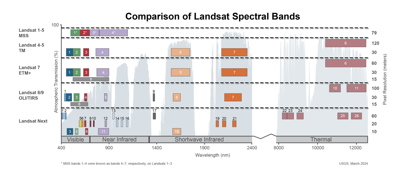
Spectral Bandpasses for all Landsat Sensors
This image shows the spectral bandpasses for the sensors on all Landsat satellites.
This image shows the spectral bandpasses for the sensors on all Landsat satellites.
Landsat 9 image of San Francisco Bay Area captured October 29, 2023
A Landsat 9 satellite image of the San Francisco Bay Area captured on October 29, 2023.
A Landsat 9 satellite image of the San Francisco Bay Area captured on October 29, 2023.
Landsat 9 image of the White Mountain National Forest, New Hampshire
Natural color image of the White Mountain National Forest, New Hampshire, as seen by Landsat 9 on October 4th, 2023.
WRS-2 Path 013 Row 029.
Bands 4,3,2
Landsat Scene ID LC09_L2SP_013029_20231004_20231005_02_T1
Natural color image of the White Mountain National Forest, New Hampshire, as seen by Landsat 9 on October 4th, 2023.
WRS-2 Path 013 Row 029.
Bands 4,3,2
Landsat Scene ID LC09_L2SP_013029_20231004_20231005_02_T1
Landsat 9 image of Lake Sunapee in 2023
An example of a Landsat 9 image of the Lake Sunapee, New Hampshire April 13th, 2023. Path:013/Row: 30. Natural Color (4,3,2).
Visit the Landsat Missions Web Site to learn more about Landsat missions and products.
An example of a Landsat 9 image of the Lake Sunapee, New Hampshire April 13th, 2023. Path:013/Row: 30. Natural Color (4,3,2).
Visit the Landsat Missions Web Site to learn more about Landsat missions and products.
Trio of Landsat Satellites Capture Alberta Fires May 2023
The three active Landsat satellites captured imagery of fires burning in an area of the Alberta province, Canada, in May of 2023.
This animation displays mosaics of the imagery acquired by Landsat 9’s Operational Land Imager (OLI) on May 13th, Landsat 8’s OLI on May 14th, and Landsat 7’s Enhanced Thematic Mapper Plus (ETM+) on May 16th.
The three active Landsat satellites captured imagery of fires burning in an area of the Alberta province, Canada, in May of 2023.
This animation displays mosaics of the imagery acquired by Landsat 9’s Operational Land Imager (OLI) on May 13th, Landsat 8’s OLI on May 14th, and Landsat 7’s Enhanced Thematic Mapper Plus (ETM+) on May 16th.
Landsat 9 Image of Shiveluch Volcano
Found along the Pacific Ring of Fire, Russia’s Shiveluch Volcano began erupting on April 11, 2023. Huge ash clouds spewed from the main crater blanketing over 40,000 square miles (108,000 square kilometers). The tiny village of Klyuchi, about 30 mi (50 km) from the volcano, plunged into darkness.
Found along the Pacific Ring of Fire, Russia’s Shiveluch Volcano began erupting on April 11, 2023. Huge ash clouds spewed from the main crater blanketing over 40,000 square miles (108,000 square kilometers). The tiny village of Klyuchi, about 30 mi (50 km) from the volcano, plunged into darkness.
Landsat 9 Image of Washington D.C.
Landsat 9 image showing Washington D.C. on April 9, 2023. The image is shown using the Red, Green and Blue bands (Bands 4,3,2), combining these three bands produces a natural color view of the area. The image was then sharpened using the panchromatic band (Band 8) which has a higher resolution than the other bands (15 meters compared to 30 meters).
Landsat 9 image showing Washington D.C. on April 9, 2023. The image is shown using the Red, Green and Blue bands (Bands 4,3,2), combining these three bands produces a natural color view of the area. The image was then sharpened using the panchromatic band (Band 8) which has a higher resolution than the other bands (15 meters compared to 30 meters).
Landsat 9 Image of Sacramento Valley on December 13, 2022
This natural color Landsat 9 image (Bands 4|3|2) was acquired on December 13, 2022 and shows the Sacramento Valley and surrounding area.
This natural color Landsat 9 image (Bands 4|3|2) was acquired on December 13, 2022 and shows the Sacramento Valley and surrounding area.
Landsat 9 image of Hurricane Ian with Cuba
Landsat 9 image of Hurricane Ian as the eye of the storm passed north of Cuba on the morning of Tuesday, September 27, 2022. The image has the island boundary overlaid on it. Image credit: USGS EROS
Landsat 9 image of Hurricane Ian as the eye of the storm passed north of Cuba on the morning of Tuesday, September 27, 2022. The image has the island boundary overlaid on it. Image credit: USGS EROS
Landsat 9 Image of Kangerdlugssuaq Glacier, Greenland
Named after a Greenlandic word meaning “large fjord,” Kangerdlugssuaq Glacier is one of the largest tidewater outlet glaciers in Greenland. It flows from the fjord of the same name, the second largest found on the east side of the island. This false color Landsat 9 image was acquired July 29, 2022, using Bands 5|4|3.
Named after a Greenlandic word meaning “large fjord,” Kangerdlugssuaq Glacier is one of the largest tidewater outlet glaciers in Greenland. It flows from the fjord of the same name, the second largest found on the east side of the island. This false color Landsat 9 image was acquired July 29, 2022, using Bands 5|4|3.
Landsat 9 Image of Aorounga Crater
The Aorounga Crater located in Chad, Africa is a large impact crater that appears as a circular depression surrounded by a raised rim, as seen in this Landsat 9 image. The crater is surrounded by a vast expanse of desert and is known for its unique rock ridges, known as yardangs.
The Aorounga Crater located in Chad, Africa is a large impact crater that appears as a circular depression surrounded by a raised rim, as seen in this Landsat 9 image. The crater is surrounded by a vast expanse of desert and is known for its unique rock ridges, known as yardangs.
Landsat 9 image of the Dallas - Fort Worth Area
This Landsat 9 image, showing the Dallas - Fort Worth area of Texas, was acquired on July 15, 2022. This false-color image vegetated land in shades of red, whereas grays and whites indicate urban or rocky surfaces.
This Landsat 9 image, showing the Dallas - Fort Worth area of Texas, was acquired on July 15, 2022. This false-color image vegetated land in shades of red, whereas grays and whites indicate urban or rocky surfaces.
Landsat 9 image over Svalbard, Norway
Landsat 9 image over Svalbard, Norway. Acquired on July 8, 2022, Path 26 Row 240. For more information on Landsat data, visit the Landsat Mission Website.
Landsat 9 image over Svalbard, Norway. Acquired on July 8, 2022, Path 26 Row 240. For more information on Landsat data, visit the Landsat Mission Website.
Landsat 9 Image of Washburn Fire, Yosemite National Park - July 7, 2022
The Washburn Fire started July 7, 2022 in the southern part of Yosemite National Park. Landsats 8 and 9 both captured imagery of it a day later. The Landsat 9 image uses shortwave infrared and near-infrared bands to show the active burning.
The Washburn Fire started July 7, 2022 in the southern part of Yosemite National Park. Landsats 8 and 9 both captured imagery of it a day later. The Landsat 9 image uses shortwave infrared and near-infrared bands to show the active burning.
Landsat 9 Image of Prudhoe Bay, Alaska
In Alaska, the Sagavanirktok River flows North to empty in Beaufort Sea near Prudhoe Bay. Landsat 9 captured this false color image on July 1, 2022, using Bands 6|5|4.
In Alaska, the Sagavanirktok River flows North to empty in Beaufort Sea near Prudhoe Bay. Landsat 9 captured this false color image on July 1, 2022, using Bands 6|5|4.
Landsat 9 image over Norway
Landsat 9 image acquired on June 27, 2022 (Path 198 Row 11) over Norway. For more information on Landsat data, visit the Landsat Mission Website.
Landsat 9 image acquired on June 27, 2022 (Path 198 Row 11) over Norway. For more information on Landsat data, visit the Landsat Mission Website.
First Images by Landsat 9 Released
First Images by Landsat 9 Released
USGS Opens Door to Data
USGS Opens Door to Data
Landsat 9 Data to be Reprocessed at the End of 2022
All Landsat 9 Collection 2 Operational Land Imager (OLI) and Thermal Infrared Sensor (TIRS) data will be reprocessed at the end of 2022 to take advantage of calibration updates identified during the first year of operation.
How is the Landsat 8 and Landsat 9 Cirrus Band 9 used?
The Operational Land Imager’s Band 9 1.360-1.390 µm on Landsat 8 and Landsat 9 detects thin, high-altitude clouds composed of ice crystals that might not be visible in other spectral bands. In Band 9, cirrus clouds appear bright while most land surfaces appear dark through an otherwise cloud-free atmosphere containing water vapor. Learn more: Landsat 8 Mission Landsat 9 Mission Landsat 8 & 9 bands...
How is the Landsat 8 and Landsat 9 Coastal/Aerosol Band 1 used?
The Operational Land Imager Band 1 ( 0.433-0.453 µm) on Landsat 8 and Landsat 9 is useful for imaging shallow water and tracking fine atmospheric particles like dust and smoke. Band 1 reflects blues and violets, where light is scattered by dust, smoke, and water particles in the air. Collecting data with enough sensitivity at this spectrum is difficult. Since water absorbs and scatters light...
What sensors does the Landsat 9 satellite carry?
Landsat 9 carries the same instruments that are on the Landsat 8 satellite but with some improvements: Operational Land Imager (OLI) for reflective band data. Thermal Infrared Sensor (TIRS) for the thermal infrared bands. OLI has a slightly improved signal-to-noise ratio over Landsat 8's OLI. Landsat 9’s TIRS is a Class-B instrument with a five-year design life and a key improvement of stray light...
When was the Landsat 9 satellite launched?
Landsat 9—a partnership between the USGS and NASA—was launched from Space Launch Complex 3E at Vandenberg Air Force Base in California upon a United Launch Alliance Atlas V 401 launch vehicle on September 27, 2021. Learn more: Landsat 9 Mission