
Comparison of the water pond in Halema‘uma‘u on November 20, 2019, and March 1, 2020. Camera and lens same for both photos. Since November 20, 2019, the pond deepened 10 m (33 ft) and widened more than 50 m (164 ft) east-west and 30 m (98 ft) north-south. Circled clusters of rocks did not move between photos, evidence of slope stability.
Images
Images intro.
Filter Total Items: 7146

Water pond in Halema‘uma‘u continues to grow
Comparison of the water pond in Halema‘uma‘u on November 20, 2019, and March 1, 2020. Camera and lens same for both photos. Since November 20, 2019, the pond deepened 10 m (33 ft) and widened more than 50 m (164 ft) east-west and 30 m (98 ft) north-south. Circled clusters of rocks did not move between photos, evidence of slope stability.

USGS Earthquake Response team with governor of Puerto Rico
USGS team with Wanda Vazquez-Garced, governor of Puerto Rico. From left to right: Lindsay Davis, Wanda Vazquez, Dianne Lopez-Trujillo, Jonathan Godt, Donyelle Davis, Alex Grant
USGS team with Wanda Vazquez-Garced, governor of Puerto Rico. From left to right: Lindsay Davis, Wanda Vazquez, Dianne Lopez-Trujillo, Jonathan Godt, Donyelle Davis, Alex Grant

Analyzing Earthquake Data in Puerto Rico
USGS scientists Thomas L. Pratt and Alena L. Leads, along with Dr. Elizabeth Vanacore, associate research professor at University of Puerto Rico, analyze data in earthquake monitoring and recording equipment amid aftershocks across the island's southern coast.
USGS scientists Thomas L. Pratt and Alena L. Leads, along with Dr. Elizabeth Vanacore, associate research professor at University of Puerto Rico, analyze data in earthquake monitoring and recording equipment amid aftershocks across the island's southern coast.

A pack string crossing the Yellowstone River in the remote Thorofare region
A pack string crossing the Yellowstone River in the remote Thorofare region. National Park Service photo courtesy of Sherrie and Ron White, August 21, 2016.
A pack string crossing the Yellowstone River in the remote Thorofare region. National Park Service photo courtesy of Sherrie and Ron White, August 21, 2016.
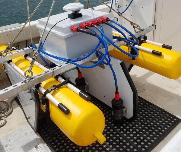
SQUID-5 - Structure-from-Motion Quantitative Underwater Imaging Device
The SQUID-5, or a Structure-from-Motion (SfM) Quantitative Underwater Imaging Device with 5 cameras is a towed surface vehicle with an onboard Global Navigation Satellite System (GNSS) and 5 downward-looking cameras with overlapping views of the seafloor.
The SQUID-5, or a Structure-from-Motion (SfM) Quantitative Underwater Imaging Device with 5 cameras is a towed surface vehicle with an onboard Global Navigation Satellite System (GNSS) and 5 downward-looking cameras with overlapping views of the seafloor.

Visitors in the busy Old Faithful area
Visitors in the busy Old Faithful area. National Park Service photo by Neal Herbert, May 27, 2017.
Visitors in the busy Old Faithful area. National Park Service photo by Neal Herbert, May 27, 2017.

Map of roads in the Greater Yellowstone Ecosystem
Map of roads in the Greater Yellowstone Ecosystem. Source: Yellowstone Spatial Analysis Center.
Map of roads in the Greater Yellowstone Ecosystem. Source: Yellowstone Spatial Analysis Center.

Florida Coral Reefs and Coastal Hazard Risk Reduction
Rigorously Valuing the Role of Florida’s Coral Reefs in Coastal Hazard Risk Reduction
Estimated Annual Benefits
Rigorously Valuing the Role of Florida’s Coral Reefs in Coastal Hazard Risk Reduction
Estimated Annual Benefits

American Samoa Coral Reefs and Coastal Hazard Risk Reduction
Rigorously Valuing the Role of American Samoa’s Coral Reefs in Coastal Hazard Risk Reduction
Estimated Annual Benefits
Rigorously Valuing the Role of American Samoa’s Coral Reefs in Coastal Hazard Risk Reduction
Estimated Annual Benefits

Guam and CNMI Coral Reefs and Coastal Hazard Risk Reduction
Rigorously Valuing the Role of Guam’s Coral Reefs and the Commonwealth of the Northern Mariana Islands’s Coral Reefs in Coastal Hazard Risk Reduction
Estimated Annual Benefits
Rigorously Valuing the Role of Guam’s Coral Reefs and the Commonwealth of the Northern Mariana Islands’s Coral Reefs in Coastal Hazard Risk Reduction
Estimated Annual Benefits

Hawaiʻi Coral Reefs and Coastal Hazard Risk Reduction
Rigorously Valuing the Role of Hawaiʻi’s Coral Reefs in Coastal Hazard Risk Reduction
Estimated Annual Benefits
Rigorously Valuing the Role of Hawaiʻi’s Coral Reefs in Coastal Hazard Risk Reduction
Estimated Annual Benefits

U.S. Virgin Islands Coral Reefs and Coastal Hazard Risk Reduction
Rigorously Valuing the Role of the U.S. Virgin Islands’ Coral Reefs in Coastal Hazard Risk Reduction
Estimated Annual Benefits
Rigorously Valuing the Role of the U.S. Virgin Islands’ Coral Reefs in Coastal Hazard Risk Reduction
Estimated Annual Benefits

Puerto Rico Coral Reefs and Coastal Hazard Risk Reduction
Rigorously Valuing the Role of Puerto Rico’s Coral Reefs in Coastal Hazard Risk Reduction
Estimated Annual Benefits
Rigorously Valuing the Role of Puerto Rico’s Coral Reefs in Coastal Hazard Risk Reduction
Estimated Annual Benefits

A typical section of shoreline in the Kapoho area, formed by thick toothpaste la
A typical section of shoreline in the Kapoho area, formed by thick toothpaste lava that originated from Fissure 8 during the 2018 eruption. USGS photo by M. Zoeller.
A typical section of shoreline in the Kapoho area, formed by thick toothpaste lava that originated from Fissure 8 during the 2018 eruption. USGS photo by M. Zoeller.

Halema‘uma‘u crater lake on January 31
Field observations today show that the diameters of the crater lake within Halema‘uma‘u at the summit of Kīlauea are about 94 m (308 ft) north-south and around 192-195 m (630-640 ft) east-west. Too much steam at the west end interfered with measurements this morning.
Field observations today show that the diameters of the crater lake within Halema‘uma‘u at the summit of Kīlauea are about 94 m (308 ft) north-south and around 192-195 m (630-640 ft) east-west. Too much steam at the west end interfered with measurements this morning.

Water samples collected from Halema‘uma‘u crater lake on January 17
On January 17, 2020, USGS-HVO scientists and DOI Unoccupied Aerial System (UAS) team members collected three additional samples of water from the Halema‘uma‘u crater lake. Here, the sampling device and temperature logger were readied for takeoff. The plastic sleeve was attached to the UAS (drone) with a cord about 20 feet (6 m) long.
On January 17, 2020, USGS-HVO scientists and DOI Unoccupied Aerial System (UAS) team members collected three additional samples of water from the Halema‘uma‘u crater lake. Here, the sampling device and temperature logger were readied for takeoff. The plastic sleeve was attached to the UAS (drone) with a cord about 20 feet (6 m) long.

Schematic diagram of the magmatic system underneath Yellowstone caldera and the
Schematic diagram of the magmatic system underneath Yellowstone caldera and the processes leading to a "shadow zone".
Schematic diagram of the magmatic system underneath Yellowstone caldera and the processes leading to a "shadow zone".

GeoGirls Geology and Technology Field Camp 2020
GeoGirls Geology and Technology Field Camp 2020
GeoGirls Geology and Technology Field Camp 2020

Cascades Volcano Observatory Open House May 9, 2020
Cascades Volcano Observatory Open House May 9, 2020
Cascades Volcano Observatory Open House May 9, 2020

Seismometer installation in Ridgecrest, California
USGS scientists Nicholas van der Elst and Alan Yong installing a seismometer near the 2019 Ridgecrest earthquakes in southern California in order to record its aftershocks.
USGS scientists Nicholas van der Elst and Alan Yong installing a seismometer near the 2019 Ridgecrest earthquakes in southern California in order to record its aftershocks.

GPS in the Phragmites
USGS technician Jennifer O’Keefe Suttles stands within a Phragmites stand within the Herring River Estuary, part of the Cape Cod National Seashore.
USGS technician Jennifer O’Keefe Suttles stands within a Phragmites stand within the Herring River Estuary, part of the Cape Cod National Seashore.