
Seismologist installing equipment at station NED on Mount St. Helens, Washington. Mount Rainier in distance.
Images
Images intro.
Filter Total Items: 7146

Seismologist installing equipment at station NED on Mount St. Helen...
Seismologist installing equipment at station NED on Mount St. Helens, Washington. Mount Rainier in distance.
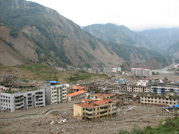
Damage from 2008 Great Sichuan Earthquake in China
The May 12, 2008, Great Sichuan Earthquake, also called the Wenchuan Earthquake, occurred at 14:28 local time, in Sichuan Province, China. The earthquake magnitudes were Mw = 7.9 (USGS), Ms = 8.0 (Chinese Earthquake Administration). The epicenter was 80 km west-northwest of Chengdu, the capital city of Sichuan province.
The May 12, 2008, Great Sichuan Earthquake, also called the Wenchuan Earthquake, occurred at 14:28 local time, in Sichuan Province, China. The earthquake magnitudes were Mw = 7.9 (USGS), Ms = 8.0 (Chinese Earthquake Administration). The epicenter was 80 km west-northwest of Chengdu, the capital city of Sichuan province.

Utilities on San Andreas Fault
Directly on the San Andreas with high pressure gas lines underground and high voltage power lines overhead at Cajon Pass, CA
Directly on the San Andreas with high pressure gas lines underground and high voltage power lines overhead at Cajon Pass, CA

Utilities on San Andreas Fault
Directly on the San Andreas with high pressure gas lines underground and high voltage power lines overhead at Cajon Pass, CA
Directly on the San Andreas with high pressure gas lines underground and high voltage power lines overhead at Cajon Pass, CA

Slumgullion Landslide
Photograph of the active (upslope from the highway that crosses the landslide deposit) and inactive (downslope from the highway) parts of the Slumgullion landslide in Hinsdale County, Colorado.
Photograph of the active (upslope from the highway that crosses the landslide deposit) and inactive (downslope from the highway) parts of the Slumgullion landslide in Hinsdale County, Colorado.

Gas flux measurement taken over altered ground at Brimstone Basin
Gas flux measurement being taken over altered ground at Brimstone Basin, Yellowstone.
Gas flux measurement being taken over altered ground at Brimstone Basin, Yellowstone.

Gas flows up, appearing to boil, through the water of Alluvium Cree...
Gas flows up, appearing to boil, through the water of Alluvium Creek, Brimstone Basin, Yellowstone. Large funnel is used to trap gas, which is then sent to a collection bottle through the tubing.
Gas flows up, appearing to boil, through the water of Alluvium Creek, Brimstone Basin, Yellowstone. Large funnel is used to trap gas, which is then sent to a collection bottle through the tubing.

Sulfur flow (darker gray area) on an altered ground surface at Brim...
Sulfur flow (darker gray area) on an altered ground surface at Brimstone Basin, Yellowstone Lake in background.
Sulfur flow (darker gray area) on an altered ground surface at Brimstone Basin, Yellowstone Lake in background.

USGS HVO, Kīlauea, Hawaii
The Hawaiian Volcano Observatory perched on the west rim of Kīlauea Volcano's summit caldera, overlooks Halema‘uma‘u Crater, where a new vent that opened in March 2008 emits a volcanic gas plume.
The Hawaiian Volcano Observatory perched on the west rim of Kīlauea Volcano's summit caldera, overlooks Halema‘uma‘u Crater, where a new vent that opened in March 2008 emits a volcanic gas plume.

HVO on rim of Kīlauea's summit caldera overlooking Halema‘uma‘u, Ha...
The Hawaiian Volcano Observatory, the first volcano observatory in the United States, is located on the west rim of Kīlauea Volcano's summit caldera in Hawai‘i Volcanoes National Park. A volcanic gas plume rises from a vent that opened in 2008 at the base of the south wall of Halema‘uma‘u Crater. Crater Rim Drive in foreground.
The Hawaiian Volcano Observatory, the first volcano observatory in the United States, is located on the west rim of Kīlauea Volcano's summit caldera in Hawai‘i Volcanoes National Park. A volcanic gas plume rises from a vent that opened in 2008 at the base of the south wall of Halema‘uma‘u Crater. Crater Rim Drive in foreground.

HVO on rim of Kīlauea's summit caldera overlooking Halema‘uma‘u, Ha...
The U.S. Geological Survey's Hawaiian Volcano Observatory, the first volcano observatory in the United States, is located on the west rim of Kīlauea Volcano's summit caldera in Hawai‘i Volcanoes National Park. A volcanic gas plume rises from a vent that opened in 2008 at the base of the south wall of Halema‘uma‘u Crater. Crater Rim Drive in foreground.
The U.S. Geological Survey's Hawaiian Volcano Observatory, the first volcano observatory in the United States, is located on the west rim of Kīlauea Volcano's summit caldera in Hawai‘i Volcanoes National Park. A volcanic gas plume rises from a vent that opened in 2008 at the base of the south wall of Halema‘uma‘u Crater. Crater Rim Drive in foreground.

Volcanic-gas plumes emitted by ocean entry, Pu‘u ‘Ō‘ō vent, and Hal...
Volcanic-gas plumes mark the sites where lava flows from Pu‘u ‘Ō‘ō enter the ocean on Kīlauea's south coast (far left), the Pu‘u ‘Ō‘ō cone (left) on the East Rift Zone, and Halema‘uma‘u Crater at the summit (right). Structures visible in middle left primarily located around the Volcano Golf and Country Club and Kīlauea Military Camp.
Volcanic-gas plumes mark the sites where lava flows from Pu‘u ‘Ō‘ō enter the ocean on Kīlauea's south coast (far left), the Pu‘u ‘Ō‘ō cone (left) on the East Rift Zone, and Halema‘uma‘u Crater at the summit (right). Structures visible in middle left primarily located around the Volcano Golf and Country Club and Kīlauea Military Camp.

Protected Species Observer aboard CCGS Louis S. St-Laurent
Protected Species Observer aboard CCGS Louis S. St-Laurent
Protected Species Observer aboard CCGS Louis S. St-Laurent

USGS Hawaiian Volcano Observatory Monitors Kilauea's Summit Eruption
The USGS Hawaiian Volcano Observatory (foreground) is located on the caldera rim of Kilauea Volcano, Hawai'i—the most active volcano in the world. The observatory's location provides an excellent view of summit eruptive activity, which began in 2008.
The USGS Hawaiian Volcano Observatory (foreground) is located on the caldera rim of Kilauea Volcano, Hawai'i—the most active volcano in the world. The observatory's location provides an excellent view of summit eruptive activity, which began in 2008.

USGS Hawaiian Volcano Observatory
The USGS Hawaiian Volcano Observatory is perched on the rim of Kilauea Volcano's summit caldera (next to the Thomas A. Jaggar Museum in Hawai'i Volcanoes National Park), providing a spectacular view of the active vent in Halema‘uma‘u Crater.
The USGS Hawaiian Volcano Observatory is perched on the rim of Kilauea Volcano's summit caldera (next to the Thomas A. Jaggar Museum in Hawai'i Volcanoes National Park), providing a spectacular view of the active vent in Halema‘uma‘u Crater.
The USGS Hawaiian Volcano Observatory Monitors Kilauea's Summit Eruption
The USGS Hawaiian Volcano Observatory (foreground) is located on the caldera rim of Kilauea Volcano, Hawai'ithe most active volcano in the world. The observatory's location provides an excellent view of summit eruptive activity, which began in 2008.
The USGS Hawaiian Volcano Observatory (foreground) is located on the caldera rim of Kilauea Volcano, Hawai'ithe most active volcano in the world. The observatory's location provides an excellent view of summit eruptive activity, which began in 2008.

Hawaiian Volcano Observatory field geologists track activity at fissure 8 (pictu
Hawaiian Volcano Observatory field geologists track activity at fissure 8 (pictured in the background). Crews collect fissure 8 tephra (Pele's hair, pumice, and other lightweight volcanic glass fragments) for geochemical analyses and characterization of changes in lava fountain behavior.
Hawaiian Volcano Observatory field geologists track activity at fissure 8 (pictured in the background). Crews collect fissure 8 tephra (Pele's hair, pumice, and other lightweight volcanic glass fragments) for geochemical analyses and characterization of changes in lava fountain behavior.

U.S. and Canadian Ships in Arctic Ocean
Helicopter view of Canadian Coast Guard Ship Louis S. St. Laurent (top) and U.S. Coast Guard Cutter Healy (bottom) on the Arctic Ocean. This was during a scientific expedition to map the extended continental shelf in the Arctic Ocean.
Helicopter view of Canadian Coast Guard Ship Louis S. St. Laurent (top) and U.S. Coast Guard Cutter Healy (bottom) on the Arctic Ocean. This was during a scientific expedition to map the extended continental shelf in the Arctic Ocean.

Lidar instrument uses light pulses to measure distances to ground s...
Lidar instrument uses light pulses to measure distances to the ground surface in the Kīlauea Caldera, Hawaii. Measurements are used to make a Digital Elevation Model - a very accurate topographic map.
Lidar instrument uses light pulses to measure distances to the ground surface in the Kīlauea Caldera, Hawaii. Measurements are used to make a Digital Elevation Model - a very accurate topographic map.

Sonobuoy reciever launch
Launching a sonobuoy receiver off the end of CCGS Louis S. St-Laurent
Launching a sonobuoy receiver off the end of CCGS Louis S. St-Laurent

Permafrost Erosion Measurement
USGS researcher Benjamin Jones examines a collapsed block of ice-rich permafrost on Barter Island along Alaska's Arctic coast.
USGS researcher Benjamin Jones examines a collapsed block of ice-rich permafrost on Barter Island along Alaska's Arctic coast.