
Missing visitor a tragic reminder of Kīlauea's danger
Images
Images intro.
Filter Total Items: 7147

Missing visitor a tragic reminder of Kīlauea's danger
Missing visitor a tragic reminder of Kīlauea's danger

26 years since last Mauna Loa eruption
26 years since last Mauna Loa eruption
26 years since last Mauna Loa eruption

Mauna Loa poses most serious threat to South Kona
Mauna Loa poses most serious threat to South Kona
Mauna Loa poses most serious threat to South Kona

Active flows entering ocean near Kamoamoa
Active flows entering ocean near Kamoamoa
Active flows entering ocean near Kamoamoa

Lava flows from two Pu'u 'O'o vents
Lava flows from two Pu'u 'O'o vents
Lava flows from two Pu'u 'O'o vents

Recent earthquake activity recalls Kapoho eruption
Recent earthquake activity recalls Kapoho eruption
Recent earthquake activity recalls Kapoho eruption

Most active seismic zone in the nation here
Most active seismic zone in the nation here
Most active seismic zone in the nation here

Episode 51 continuing
Episode 51 continuing

A volcano that just keeps rolling along: HVO tracks eruption's phases
A volcano that just keeps rolling along: Hawaiian Volcano Observatory tracks eruption's phases
A volcano that just keeps rolling along: Hawaiian Volcano Observatory tracks eruption's phases

Three earthquakes felt in past two weeks: Hawaii Tribune-Herald
Three earthquakes felt in past two weeks: Hawaii Tribune-Herald
Three earthquakes felt in past two weeks: Hawaii Tribune-Herald

Eruption's flows continue, danger remains
Eruption's flows continue, danger remains
Eruption's flows continue, danger remains

Lava consolidates but flow remains steady
Lava consolidates but flow remains steady
Lava consolidates but flow remains steady

More lava flowing than scientists thought
More lava flowing than scientists thought
More lava flowing than scientists thought

Lava taking Hawaiian village, nearing arch
Lava taking Hawaiian village, nearing arch
Lava taking Hawaiian village, nearing arch

Map of Yellowstone earthquakes as located by the Univ. of Utah Seis...
Red circles represent all seismicity and blue circles represent earthquakes as part of earthquake swarms. The size of the circles is scaled to the magnitude of the earthquake. The 630,000 year old Yellowstone caldera is shown as a bold black line within Yellowstone National Park. Mapped faults are shown as light gray lines.
Red circles represent all seismicity and blue circles represent earthquakes as part of earthquake swarms. The size of the circles is scaled to the magnitude of the earthquake. The 630,000 year old Yellowstone caldera is shown as a bold black line within Yellowstone National Park. Mapped faults are shown as light gray lines.

Rockfalls trigger explosions in Kīlauea's summit lava lake
This video shows a rockfall and subsequent explosion that occurred at 7:03 a.m. HST today within the "Overlook crater" at the summit of Kīlauea. This collapse was followed by a smaller rockfall at 7:07 a.m. (not shown in video).
This video shows a rockfall and subsequent explosion that occurred at 7:03 a.m. HST today within the "Overlook crater" at the summit of Kīlauea. This collapse was followed by a smaller rockfall at 7:07 a.m. (not shown in video).

"Dimples" in the Pele's hair that has accumulated on the rim of Hal...
"Dimples" in the Pele's hair that has accumulated on the rim of Halema‘uma‘u are evidence of ballistic impacts during today's rockfall-triggered explosion in Kīlauea Volcano's summit lava lake. Spatter (fragments of molten lava) blasted from the lava lake landed all around HVO's thermal camera (HTcam) that monitors lake activity.
"Dimples" in the Pele's hair that has accumulated on the rim of Halema‘uma‘u are evidence of ballistic impacts during today's rockfall-triggered explosion in Kīlauea Volcano's summit lava lake. Spatter (fragments of molten lava) blasted from the lava lake landed all around HVO's thermal camera (HTcam) that monitors lake activity.

Spatter up to about 30 cm (11.8 in) in size was hurled onto rim of ...
Spatter up to about 30 cm (11.8 in) in size was hurled onto the rim of Halema‘uma‘u during today's explosive events. Some fragments were thrown or blown farther downwind, reaching as far as the closed section of Crater Rim Drive in Hawai‘i Volcanoes National Park.
Spatter up to about 30 cm (11.8 in) in size was hurled onto the rim of Halema‘uma‘u during today's explosive events. Some fragments were thrown or blown farther downwind, reaching as far as the closed section of Crater Rim Drive in Hawai‘i Volcanoes National Park.

Keeping informed about Hawaii volcanoes is first step to preparedness
Spectacular aerial view of Kīlauea Volcano's East Rift Zone lava flows advancing over Pūlama pali in December 2017. As surface lava flows moved through the center kipuka (forested area) on the pali, smoke rose from the burning vegetation.
Spectacular aerial view of Kīlauea Volcano's East Rift Zone lava flows advancing over Pūlama pali in December 2017. As surface lava flows moved through the center kipuka (forested area) on the pali, smoke rose from the burning vegetation.
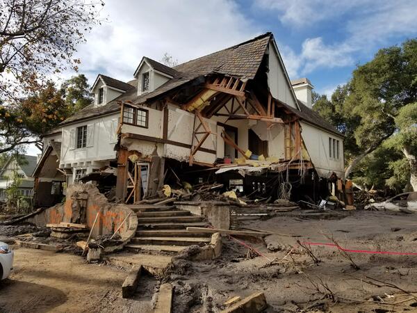
Montecito home damaged by post-wildfire debrisflow.
Damage from a major post-wildfire landslide that occurred on 9 January 2018 near Montecito, Santa Barbara County as a result of the 2017 Thomas Fire.
Damage from a major post-wildfire landslide that occurred on 9 January 2018 near Montecito, Santa Barbara County as a result of the 2017 Thomas Fire.

Doublet Pool, fringed by geyserite, in the Upper Geyser Basin of YNP.
Doublet Pool, fringed by geyserite, in the Upper Geyser Basin of Yellowstone National Park. National Park Service photograph by Jacob Frank.
Doublet Pool, fringed by geyserite, in the Upper Geyser Basin of Yellowstone National Park. National Park Service photograph by Jacob Frank.