
Colin Sweeney, USGS, collecting water-quality samples from the Connecticut River, CT
Images
Explore water-related photography, imagery, and illustrations.
Filter Total Items: 2402

Collecting winter water-quality samples in the Connecticut River, CT
Colin Sweeney, USGS, collecting water-quality samples from the Connecticut River, CT

Collecting winter water-quality samples from the Connecticut River nea
Theresa Armijo, USGS, collecting water-quality samples from the Connecticut River by USGS gage 01184000, Connecticut River near Thompsonville
Theresa Armijo, USGS, collecting water-quality samples from the Connecticut River by USGS gage 01184000, Connecticut River near Thompsonville

Clearing ice from the path to the river for water-quality sampling
David Sullivan, USGS, using an ice bar to chip away at the ice built up on the trail to get down to the water-quality sampling site at USGS gage Connecticut River near Thompsonville, CT
David Sullivan, USGS, using an ice bar to chip away at the ice built up on the trail to get down to the water-quality sampling site at USGS gage Connecticut River near Thompsonville, CT

Spring 2019 Flooding - Wild Rice River in Minnesota
WWG Reading on the Wild Rice River in Minnesota during record Midwest flooding in spring 2019.
WWG Reading on the Wild Rice River in Minnesota during record Midwest flooding in spring 2019.

USGS streamgage number 13309220 on Idaho's Middle Fork of the Salmon R
USGS streamgage number 13309220 on Idaho's Middle Fork of the Salmon River in the Frank Church River of No Return Wilderness Area.
USGS streamgage number 13309220 on Idaho's Middle Fork of the Salmon River in the Frank Church River of No Return Wilderness Area.

Hydrologic technician services gage 10329500 MARTIN Creek, NV
Recently retired hydrologic technician Doug Hutchinson services gage 10329500 MARTIN Creek near Paradise Valley, NV, March of 2019. This gage is designated as a centennial gage for FY21! Happy birthday, Martin Creek near Paradise Valley!
Recently retired hydrologic technician Doug Hutchinson services gage 10329500 MARTIN Creek near Paradise Valley, NV, March of 2019. This gage is designated as a centennial gage for FY21! Happy birthday, Martin Creek near Paradise Valley!

U.S. River Conditions for Water Year 2018 carousel
This is an animation showing the changing conditions of USGS streamgages for Water Year 2018 (October 1, 2017 to September 30, 2018). The conditions shown range from the driest condition seen at a gage to the wettest.
This is an animation showing the changing conditions of USGS streamgages for Water Year 2018 (October 1, 2017 to September 30, 2018). The conditions shown range from the driest condition seen at a gage to the wettest.

USGS crews respond to flooding on the Big Sioux River
USGS technician Chris Broz helps take water measurements on the Big Sioux River during record flooding in March, 2019.
USGS technician Chris Broz helps take water measurements on the Big Sioux River during record flooding in March, 2019.

USGS crews respond to flooding on the Big Sioux River
USGS technician Chris Broz helps take water measurements on the Big Sioux River during record flooding in March, 2019.
USGS technician Chris Broz helps take water measurements on the Big Sioux River during record flooding in March, 2019.
USGS takes water measurements during Big Sioux flooding
USGS scientists and technicians took water measurements during flooding on the Big Sioux River near Jefferson, SD in March 2019. Measurements for this site were 52,000 cfs at a gage height of 40.14 ft.
USGS scientists and technicians took water measurements during flooding on the Big Sioux River near Jefferson, SD in March 2019. Measurements for this site were 52,000 cfs at a gage height of 40.14 ft.

USGS crews respond to flooding on the Big Sioux River
USGS scientists and technicians took water measurements during flooding on the Big Sioux River near Hawarden, Iowa in March 2019.
USGS scientists and technicians took water measurements during flooding on the Big Sioux River near Hawarden, Iowa in March 2019.

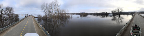
Spring 2019 Flooding - Big Sioux River, Akron, IA
After record flooding on the Big Sioux River, USGS crews mobilized to take important water measurements.
After record flooding on the Big Sioux River, USGS crews mobilized to take important water measurements.

Spring 2019 Flooding - Big Sioux River
After record flooding on the Big Sioux River, USGS crews mobilized to take important water measurements.
After record flooding on the Big Sioux River, USGS crews mobilized to take important water measurements.

Spring 2019 Flooding - Big Sioux River, Hawarden, IA
After record flooding on the Big Sioux River, USGS crews mobilized to take important water measurements.
After record flooding on the Big Sioux River, USGS crews mobilized to take important water measurements.

Spring 2019 Flooding - Big Sioux River
After record flooding on the Big Sioux River, USGS crews mobilized to take important water measurements.
After record flooding on the Big Sioux River, USGS crews mobilized to take important water measurements.


USGS Groundwater Monitoring in Winter
Groundwater science doesn't take a winter vacation! In this photo, USGS hdyrologic technician Jeremiah Pomerleau has snowshoed to a USGS groundwater monitoring site in Eustis, Maine. USGS scientists visit USGS groundwater observation wells year-round to measure water levels and maintain equipment.
Groundwater science doesn't take a winter vacation! In this photo, USGS hdyrologic technician Jeremiah Pomerleau has snowshoed to a USGS groundwater monitoring site in Eustis, Maine. USGS scientists visit USGS groundwater observation wells year-round to measure water levels and maintain equipment.

USGS crews respond to flooding on the Big Sioux River
USGS scientists and technicians took water measurements during flooding on the Big Sioux River near Hawarden, Iowa in March 2019.
USGS scientists and technicians took water measurements during flooding on the Big Sioux River near Hawarden, Iowa in March 2019.

USGS crews respond to flooding on the Big Sioux River
USGS technician Chris Broz helps take water measurements on the Big Sioux River during record flooding in March, 2019.
USGS technician Chris Broz helps take water measurements on the Big Sioux River during record flooding in March, 2019.

Spring 2019 Flooding - Louisville, NE
After record flooding in the Midwest, USGS crews mobilized to take important water measurements.
After record flooding in the Midwest, USGS crews mobilized to take important water measurements.

Spring 2019 Flooding - Forestburg, SD
USGS Dakota Water Science Center hydrologic technician Mark Brazones is using a handheld acoustic meter to measure the road overflow at the James River near Forestburg, SD.
USGS Dakota Water Science Center hydrologic technician Mark Brazones is using a handheld acoustic meter to measure the road overflow at the James River near Forestburg, SD.