
Catastrophic landslide near Oso, Washington, March 22, 2014.
Images
Images intro.
Filter Total Items: 83

Catastrophic landslide near Oso, WA, Mar. 22, 2014.
Catastrophic landslide near Oso, Washington, March 22, 2014.

Map showing one-year probability of accumulation of 1 centimeter
Map showing one-year probability of accumulation of 1 centimeter (0.4 inch) or more of tephra from eruptions of volcanoes in the Cascade Range.
Map showing one-year probability of accumulation of 1 centimeter (0.4 inch) or more of tephra from eruptions of volcanoes in the Cascade Range.

CalVO geologist Mae Marcaida examines thin layers of volcanic ash s...
CalVO geologist Mae Marcaida examines thin layers of volcanic ash sandwiched between thick beds of sediment deposited by ancestral Mono Lake in eastern California. Each ash layer is evidence of a past explosive eruption of the Mono Craters, which began erupting about 65,000 years ago just south of present-day Mono Lake.
CalVO geologist Mae Marcaida examines thin layers of volcanic ash sandwiched between thick beds of sediment deposited by ancestral Mono Lake in eastern California. Each ash layer is evidence of a past explosive eruption of the Mono Craters, which began erupting about 65,000 years ago just south of present-day Mono Lake.

Wes Hildreth at Long Valley Caldera
Wes Hildreth is an expert when it comes to studying the Long Valley Caldera. Here, he is standing on Tertiary basalt lava flows on the north rim of the caldera, view to the southeast with Lake Crowley visible in the center of the caldera, and McGee Mountain above the lake on the skyline.
Wes Hildreth is an expert when it comes to studying the Long Valley Caldera. Here, he is standing on Tertiary basalt lava flows on the north rim of the caldera, view to the southeast with Lake Crowley visible in the center of the caldera, and McGee Mountain above the lake on the skyline.

Tephra provides clues to eruptive history of Medicine Lake Volcano, CA
Geologists examine tephra deposits to better understand the early eruptive behavior of the Medicine Lake Volcano, evidence of which can be found as far away as central Oregon.
Geologists examine tephra deposits to better understand the early eruptive behavior of the Medicine Lake Volcano, evidence of which can be found as far away as central Oregon.

Carbon dioxide gas detection Horseshoe Lake, Mammoth Mountain, CA.
Carbon dioxide gas detection instrument installed at Horseshoe Lake, Mammoth Mountain, California.
Carbon dioxide gas detection instrument installed at Horseshoe Lake, Mammoth Mountain, California.

A tumulus at Captain Jack's stronghold within Lava Beds National Mo...
A tumulus at Captain Jack's stronghold within Lava Beds National Monument .
A tumulus at Captain Jack's stronghold within Lava Beds National Monument .

Volcano hazard zone map for Lassen Volcanic Region in Northern CA p...
Volcanic Hazard Assessment for the Lassen Region, California is based upon a comprehensive investigation of the eruptive history and possible future eruption scenarios with associated volcanic hazards.
Volcanic Hazard Assessment for the Lassen Region, California is based upon a comprehensive investigation of the eruptive history and possible future eruption scenarios with associated volcanic hazards.

A lava tube trace (dark sinuous shape) along the ground surface.
Aerial view of a lava tube trace (dark sinuous shape) along the ground surface at Medicine Lake Volcano, California.
Aerial view of a lava tube trace (dark sinuous shape) along the ground surface at Medicine Lake Volcano, California.

Lassen Peak viewed from the south at the summit of Brokeoff Volcano...
Lassen Peak viewed from the south at the summit of Brokeoff Volcano, Lassen Volcanic National Park.
Lassen Peak viewed from the south at the summit of Brokeoff Volcano, Lassen Volcanic National Park.

Mudpots near Salton Buttes on the edge of the Salton Sea
Mudpots bubble and steam near the Salton Buttes lava domes, a volcanic area at the southeastern end of the Salton Sea, California.
Mudpots bubble and steam near the Salton Buttes lava domes, a volcanic area at the southeastern end of the Salton Sea, California.

Chaos Crags in Lassen Volcanic National Park
Chaos Jumbles (foreground) is a rockfall avalanche that formed around 340 years ago when one of the Chaos Crags domes (background) collapsed.
Chaos Jumbles (foreground) is a rockfall avalanche that formed around 340 years ago when one of the Chaos Crags domes (background) collapsed.

View of Chaos Crags in Lassen Volcanic National Park from Lassen Peak.
Chaos Crags is a series of lava domes that erupted about 1,100 years ago from the Lassen Volcanic Center.
Chaos Crags is a series of lava domes that erupted about 1,100 years ago from the Lassen Volcanic Center.

South Sister volcano viewed northward from the east shore of Sparks Lake.
The photo includes five rhyolitic units of different ages: Unforested 2-ka rhyolite of "Devils chain" rests on forested 35,000 year old flow lobe from adjacent Devils Hill dome. Three pale-gray spurs form sharp salients that extend to elevations only 550 m (1640 ft) below the darker andesitic summit of South Sister.
The photo includes five rhyolitic units of different ages: Unforested 2-ka rhyolite of "Devils chain" rests on forested 35,000 year old flow lobe from adjacent Devils Hill dome. Three pale-gray spurs form sharp salients that extend to elevations only 550 m (1640 ft) below the darker andesitic summit of South Sister.
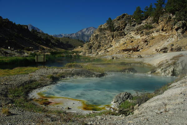
Bubbling Spring, a feature of Hot Creek in the Long Valley Caldera,...
Bubbling Spring, a feature of Hot Creek in the Long Valley Caldera, California, occasionally "boils" due to high water temperature.
Bubbling Spring, a feature of Hot Creek in the Long Valley Caldera, California, occasionally "boils" due to high water temperature.

Soil-temperature measurement at Hot Creek in Long Valley Caldera, CA.
Soil-temperature measurement at Hot Creek in Long Valley Caldera, California.
Soil-temperature measurement at Hot Creek in Long Valley Caldera, California.
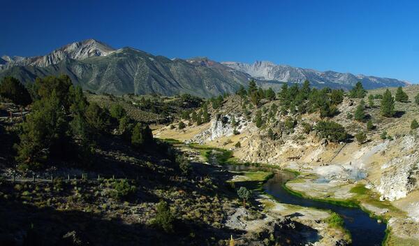
Hot Creek Gorge viewed upstream toward the SW; the steep walls of t...
Hot Creek Gorge viewed upstream toward the southwest; the steep walls of the gorge consist of a single rhyolite lava flow erupted from a vent 4 km (2.5 mi) to the south.
Hot Creek Gorge viewed upstream toward the southwest; the steep walls of the gorge consist of a single rhyolite lava flow erupted from a vent 4 km (2.5 mi) to the south.

Cinder Cone in Lassen Volcanic National Park
Cinder Cone erupted in the year 1666 in the Lassen Volcanic Region of northern California.
Cinder Cone erupted in the year 1666 in the Lassen Volcanic Region of northern California.

Aerial view west across the upper part of Medicine Lake Volcano tow...
Medicine Lake lies within the shallow basin of Medicine Lake caldera. Glass Mountain flow, draped over the east side of the volcano, is the youngest lava flow at the volcano. The northeasternmost dacite tongue extends nearly to the bottom of the photo (distal lobes are outlined to enhance visibility).
Medicine Lake lies within the shallow basin of Medicine Lake caldera. Glass Mountain flow, draped over the east side of the volcano, is the youngest lava flow at the volcano. The northeasternmost dacite tongue extends nearly to the bottom of the photo (distal lobes are outlined to enhance visibility).

Glass Mountain obsidian flow at Medicine Lake volcano, CA.
Glass Mountain obsidian flow at Medicine Lake volcano, California. Glass Mountain is a spectacular, nearly treeless, steep-sided rhyolite and dacite obsidian flow that erupted just outside the eastern caldera rim and flowed down the steep eastern flank of Medicine Lake volcano.
Glass Mountain obsidian flow at Medicine Lake volcano, California. Glass Mountain is a spectacular, nearly treeless, steep-sided rhyolite and dacite obsidian flow that erupted just outside the eastern caldera rim and flowed down the steep eastern flank of Medicine Lake volcano.

Hydrothermal system and water flow in the subsurface beneath Long V...
Hydrothermal system and water flow in the subsurface beneath Long Valley Caldera, California. Cartoon Illustration from USGS FS 2007-3045.
Hydrothermal system and water flow in the subsurface beneath Long Valley Caldera, California. Cartoon Illustration from USGS FS 2007-3045.